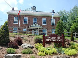
Melbourne, Quebec
Melbourne | |
|---|---|
Township municipality | |
 Town hall | |
 Location within Le Val-Saint-François RCM | |
 Melbourne Location in southern Quebec | |
| Coordinates: 45°35′N 72°10′W / 45.58°N 72.17°WCoordinates: 45°35′N 72°10′W / 45.58°N 72.17°W[1] | |
| Country | |
| Province | |
| Region | Estrie |
| RCM | Le Val-Saint-François |
| Constituted | July 1, 1855 |
| Government | |
| • Mayor | James Johnston |
| • Federal riding | Richmond—Arthabaska |
| • Prov. riding | Richmond |
| Area | |
| • Total | 173.70 km2 (67.07 sq mi) |
| • Land | 174.34 km2 (67.31 sq mi) |
| There is an apparent contradiction between two authoritative sources | |
| Population (2011)[3] | |
| • Total | 1,004 |
| • Density | 5.8/km2 (15/sq mi) |
| • Pop 2006-2011 | |
| • Dwellings | 488 |
| Time zone | UTC−5 (EST) |
| • Summer (DST) | UTC−4 (EDT) |
| Postal code(s) | J0B 2B0 |
| Area code(s) | 819 |
| Highways | |
| Website | www |
Melbourne is a township municipality located in Le Val-Saint-François Regional County Municipality in the Estrie region of Quebec, Canada.
Demographics[]
Population[]
| Year | Pop. | ±% |
|---|---|---|
| 1991 | 1,055 | — |
| 1996 | 977 | −7.4% |
| 2001 | 951 | −2.7% |
| 2006 | 1,095 | +15.1% |
| 2011 | 1,004 | −8.3% |
Language[]
Mother tongue (2011)[3]
| Language | Population | Pct (%) |
|---|---|---|
| French only | 690 | 68.0% |
| English only | 280 | 27.6% |
| English and French | 15 | 1.5% |
| Non-official languages | 15 | 1.5% |
| French and non-official language | 5 | 0.5% |
| English and non-official language | 5 | 0.5% |
| English, French and non-official language | 5 | 0.5% |

Upper Melbourne 1910
See also[]
References[]
- ^ Reference number 40419 of the Commission de toponymie du Québec (in French)
- ^ a b Geographic code 42075 in the official Répertoire des municipalités (in French)
- ^ a b c "(Code 2442075) Census Profile". 2011 census. Statistics Canada. 2012.
- ^ Statistics Canada: 1996, 2001, 2006, 2011 census
External links[]
 Media related to Melbourne, Quebec at Wikimedia Commons
- Municipality of Township of Melbourne (in English)
Categories:
- Incorporated places in Estrie
- Township municipalities in Quebec
- Estrie geography stubs
