Melmerby, Harrogate
| Melmerby | |
|---|---|
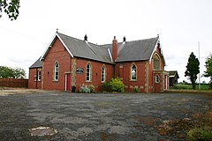 The Methodist Church in Melmerby | |
 Melmerby Location within North Yorkshire | |
| Population | 386 (2011 census)[1] |
| OS grid reference | SE337769 |
| Civil parish |
|
| District |
|
| Shire county | |
| Region | |
| Country | England |
| Sovereign state | United Kingdom |
| Post town | RIPON |
| Postcode district | HG4 |
| Police | North Yorkshire |
| Fire | North Yorkshire |
| Ambulance | Yorkshire |

Melmerby is a village and civil parish in the Harrogate district of North Yorkshire, England, that lies 3.7 miles (6 km) north of Ripon and 0.6 miles (1 km) west of the A1(M) motorway.[2] The population was 386 in the 2011 census.[1]
Etymology[]
The name is of Old Norse origin and means a sandy settlement (malmr "sandy field" and bý "farmstead or village").[3] The form of the name has been influenced by Melmerby in Coverdale, 16 miles (26 km) west, which has a different origin.[4] Many of the fields in the area have Norse names too, e.g. Halikeld, where 'keld' is an Old Norse word for 'spring'.[5]
History[]
Melmerby was mentioned in the Domesday Book. It was historically a manor and chapelry in the parish of Wath in the North Riding of Yorkshire.[6] It became a separate civil parish in 1866.[7]
Until the late 1950s, the village was the site of a major rural railway junction that was situated on the main Harrogate to Northallerton via Ripon railway line (closed 1968). A branch line ran westwards from Melmerby to the small market town of Masham, which is famous for its brewing.[8] This line stopped carrying passengers in 1930 and closed completely in 1963. Another line (closed 1959) also ran north-eastwards linking Melmerby with the East Coast Main Line at Thirsk.[9]
During the war the village was the site of a large munitions store, taking advantage of the railway access.[10]
The parish now shares a grouped parish council, Melmerby and Middleton Quernhow Parish Council, with the neighbouring parish of Middleton Quernhow.[11] The village has a pub, The George and Dragon Inn, a cricket team, the Wath & Melmerby Cricket Club, who play in the Nidderdale League and the village also stages an annual 10-kilometre (6.2 mi) road race which has been held since 1984.[12]
References[]
- ^ a b UK Census (2011). "Local Area Report – Melmerby Parish (1170217052)". Nomis. Office for National Statistics. Retrieved 11 March 2018.
- ^ "99" (Map). Northallerton & Ripon. 1:50,000. Landranger. Ordnance Survey. 2016. ISBN 978-0-3192619-7-2.
- ^ Smith, A H (1928). The place-names of the North Riding of Yorkshire (PDF). Cambridge: Cambridge University Press. p. 219. OCLC 3818214.
- ^ Watts, Victor, ed. (2010). "Melmerby NYorks SE3376". The Cambridge Dictionary of English Place-Names. Cambridge University Press. ISBN 978 0 521 16855 7.
- ^ "Richmond and Swaledale History". www.yorkshire-england.co.uk. Retrieved 3 January 2017.
- ^ William Page, ed. (1914). "Parishes: Wath". Victoria County History. A History of the County of York North Riding: Volume 1. pp. 390–396. Retrieved 4 April 2017.
- ^ Vision of Britain website
- ^ "Masham & Its History - Visit Masham". Visit Masham. Retrieved 3 January 2017.
- ^ "Disused Stations: Melmerby Station". www.disused-stations.org.uk. Retrieved 3 January 2017.
- ^ "Melmerby Ordnance Depot". www.disused-stations.org.uk. Retrieved 3 January 2017.
- ^ "Melmerby and Middleton Quernhow Parish Council". Harrogate Parish Council. Retrieved 4 April 2017.
- ^ Barnett, Ben (23 March 2019). "Helping each other". The Yorkshire Post. Country week. p. 13. ISSN 0963-1496.
External links[]
| Wikimedia Commons has media related to Melmerby, Harrogate. |
- Villages in North Yorkshire
- Civil parishes in North Yorkshire