Meredith, Colorado
Meredith, Colorado | |
|---|---|
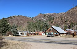 A view of Meredith from across Frying Pan Road | |
 Location in Pitkin County and the state of Colorado | |
| Coordinates: 39°21′44″N 106°43′50″W / 39.36222°N 106.73056°WCoordinates: 39°21′44″N 106°43′50″W / 39.36222°N 106.73056°W | |
| Country | |
| State | |
| County | Pitkin[1] |
| Elevation | 7,772 ft (2,369 m) |
| Time zone | UTC-7 (MST) |
| • Summer (DST) | UTC-6 (MDT) |
| ZIP code[2] | 81642 |
| GNIS feature ID | 0179732 |


Meredith is an unincorporated community and a U.S. Post Office in Pitkin County, Colorado, United States. The Meredith Post Office has the ZIP Code 81642.[2]
Meredith was a limestone quarry town as well as a lumber camp in the 1890s. It is now mainly a "resort area". There are many original occupied buildings.
Geography[]
Meredith is located at 39°21′44″N 106°43′50″W / 39.36222°N 106.73056°W (39.362174,-106.730633).
See also[]
- Colorado
- Outline of Colorado
- Bibliography of Colorado
- Geography of Colorado
- History of Colorado
- Colorado statistical areas
- Glenwood Springs, CO Micropolitan Statistical Area
- List of counties in Colorado
- List of places in Colorado
- Protected areas of Colorado
References[]
- ^ Jump up to: a b "US Board on Geographic Names". United States Geological Survey. 2007-10-25. Retrieved 2008-01-31.
- ^ Jump up to: a b "ZIP Code Lookup". United States Postal Service. January 2, 2007. Archived from the original (JavaScript/HTML) on January 1, 2008. Retrieved January 2, 2007.
External links[]
Meredith, Coloradoat Wikipedia's sister projects
 Definitions from Wiktionary
 Media from Wikimedia Commons
 News from Wikinews
 Quotations from Wikiquote
 Texts from Wikisource
 Textbooks from Wikibooks
 Resources from Wikiversity

| show Municipalities and communities of Pitkin County, Colorado, United States |
|---|

This Colorado-related article is a stub. You can help Wikipedia by . |
Categories:
- Unincorporated communities in Pitkin County, Colorado
- Unincorporated communities in Colorado
- Colorado stubs