Meteorological history of Hurricane Jeanne
| Category 3 major hurricane (SSHWS/NWS) | |
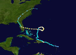 Path of Hurricane Jeanne | |
| Formed | September 13, 2004 |
|---|---|
| Dissipated | September 29, 2004 |
| (Extratropical after September 28) | |
| Highest winds | 1-minute sustained: 120 mph (195 km/h) |
| Lowest pressure | 950 mbar (hPa); 28.05 inHg |
| Areas affected | U.S. Virgin Islands, Puerto Rico, Dominican Republic, Haiti, Bahamas, Florida; flooding and damage in other eastern U.S. states |
| Part of the 2004 Atlantic hurricane season | |
The meteorological history of Hurricane Jeanne lasted for about two weeks in September 2004. Hurricane Jeanne was the eleventh tropical cyclone, tenth named storm, seventh hurricane, and sixth major hurricane of the 2004 Atlantic hurricane season. It formed from a tropical wave on September 13 near the Lesser Antilles, and encountered favorable enough conditions to reach tropical storm status. Jeanne strengthened further in the eastern Caribbean, becoming a strong tropical storm and developing an eye before striking Puerto Rico on September 15. Remaining well-organized, it attained hurricane status before hitting the eastern tip of the Dominican Republic on September 16.
Hurricane Jeanne steadily weakened while crossing eastern Hispaniola, and on September 17 it briefly weakened to tropical depression status after reaching open waters. Its original circulation dissipated as a new one reformed closer to the main area of thunderstorms. Turning northward, Jeanne slowly reorganized and again reached hurricane status on September 20. It executed a clockwise loop to the west, weakening due to upwelling upon reaching its path again. Jeanne encountered favorable conditions as it continued westward, and it reached major hurricane status before crossing the northern Bahamas on September 25. The next day, it struck Martin County, Florida in nearly the same location as Hurricane Frances just weeks before. Jeanne weakened over land while turning the northwest, deteriorating to tropical depression status over Georgia on September 27. It turned northeastward, becoming extratropical on September 28 before dissipating on September 29 after merging with a cold front.
The hurricane produced heavy rainfall across its path, including in Haiti where precipitation caused devastating mudslides; over 3,000 deaths were reported in the country. Heavy rainfall also occurred during its landfalls on Puerto Rico and Florida, resulting in river flooding. In its strongest landfall, the hurricane produced strong winds across an area earlier affected by Hurricane Frances and, in some locations, by Hurricane Charley. Late in its duration, the combination of moisture from Jeanne and cool air resulted in a tornado outbreak that extended from Georgia through the Mid-Atlantic states.
Formation and first landfall[]
The origins of Hurricane Jeanne were from a tropical wave that moved off the coast of Africa on September 7.[1] Containing a scattered area of moderate convection, the wave tracked westward at 12–17 mph (19–28 km/h), located to the south of a large ridge.[2] The system initially showed no signs of development,[3] with unfavorably dry air persisting across the region.[4] On September 11, convection became slightly better organized,[5] and the next day broad cyclonic turning became evident.[6] However, overall development was hindered by upper-level wind shear from Hurricane Ivan in the Caribbean,[7] as well as from an upper-level low to the north of the wave.[6]
Late on September 12, while approaching the northern Lesser Antilles, convection increased and became better organized around an area of increased cyclonic turning.[8] Environmental conditions became more favorable, allowing for the development of a low-pressure area and for banding features to increase.[9] Late on September 13, with the formation of a broad low-level circulation, it is estimated the system developed into Tropical Depression Eleven about 70 mi (110 km) east-southeast of Guadeloupe.[10]

Upon first becoming a tropical cyclone, the depression was located to the south of the subtropical ridge, resulting in a west-northwest track which brought the center over Guadeloupe.[1] The circulation was initially broad,[11] and dry air temporarily entrained the northwest quadrant of the storm. However, environmental conditions were favorable enough for further development, with a deepening trough to its west providing beneficial flow. Banding features improved around the circulation, and the National Hurricane Center upgraded the depression to Tropical Storm Jeanne on September 13 about 135 mi (220 km) southeast of Saint Croix.[12] While crossing the Lesser Antilles, the storm brought locally heavy rainfall, with a total of 12 inches (305 mm) reported in Guadeloupe.[1]
Tropical Storm Jeanne quickly organized over the eastern Caribbean Sea, developing a tight inner core and well-defined outflow as it tracked over warm water temperatures of about 84 °F (29 °C). Initially, the storm was forecast to attain hurricane status before crossing Puerto Rico.[13] However, its organization deteriorated by early on September 15, with radar imagery tracking a low-level circulation moving away from the convection.[14] The temporary weakening was due to increased shear and dry air.[15] At 1600 UTC on September 15, Jeanne made landfall near Guayama, Puerto Rico with winds of 70 mph (115 km/h),[1] and as it moved ashore it was in the process of developing an eye.[16] Across the territory, the storm produced heavy rainfall, peaking at 23.75 inches (605 mm) on Vieques Island. Rainfall across the region resulted in moderate to severe river flooding, with several river stations in Puerto Rico reporting historical levels. Light winds, generally around tropical storm force, affected the region as well.[1]
Second landfall and reorganization[]
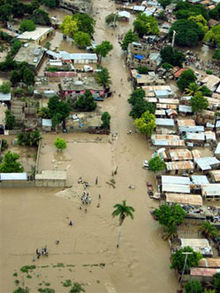
Tropical Storm Jeanne remained over Puerto Rico for about eight hours,[1] during which it maintained its eye feature and well-defined inner core of convection.[17] It intensified over the Mona Passage, and attained hurricane status as it struck the eastern tip of the Dominican Republic on September 16. Continuing slowly west-northwestward near the coast, Jeanne quickly weakened to tropical storm status,[1] and by 24 hours after landfall its convection had deteriorated as the eye feature dissipated.[18] Late on September 17, it emerged into the Atlantic Ocean as a tropical depression, after having dropped torrential rainfall across Hispaniola. Catastrophic flooding and mudslides were experienced in Haiti, including in the coastal city of Gonaïves, and over 3,000 deaths were reported in the country.[1]
On September 17, while it was over Hispaniola, the National Hurricane Center issued a forecast that predicted Jeanne to make landfall near Savannah, Georgia in about five days. However, the forecast noted uncertainty in regards to the steering currents, which depended on the movement of the remnants of Hurricane Ivan and a ridge building behind it.[19] After it left the nation as a tropical depression, the original center of circulation tracked westward away from the convection and dissipated. However, a new circulation developed closer to the convection, and Jeanne regained tropical storm status on September 18. By then, the mid-level circulation associated with Hurricane Ivan had combined with a trough to weaken the ridge located across the western Atlantic Ocean; this caused Jeanne to track northward through the Turks and Caicos Islands.[1]
As it tracked northward, the storm failed to organize at first, due to the influence of an upper-level low to its south. The circulation became broad and elongated, as well as removed from the deepest convection.[20] However, after moving away from the low, the convection became better organized and more associated with the convection.[21] After some initial slow organization continued, an area of deep convection developed over the center midday on September 20.[22] An eye developed within the convection,[23] and late on September 20 Jeanne re-attained hurricane status about 350 mi (570 km) east-northeast of the Abaco Islands in the Bahamas.[1]
While intensifying as a tropical storm, the National Hurricane Center faced difficulties in the future track of Jeanne, based on two major divergences between computer hurricane models. One scenario involved the storm accelerating east-northeastward to the south of a trough, following the path of Hurricane Karl to its east. The other scenario involved Jeanne turning southeastward and looping westward due to a building ridge. By early on September 20, the official forecast followed the first scenario,[24] though later that day, officials changed the forecast to indicate the turn to the south.[22]
Peak intensity and final landfall[]

Hurricane Jeanne steadily intensified as it turned eastward, developing a 52 mi (83 km) wide eye.[25] A motion to the southeast began on September 22, and around the same time it reached winds of 100 mph (160 km/h), making it a Category 2 hurricane on the Saffir–Simpson scale.[1] At the same time, the National Hurricane Center forecast to turn westward and later northwestward, with its projected five-day track within 60 mi (100 km) of Cape Fear, North Carolina. The westernmost outlier during one model run was the NOGAPS model, which predicted a continued westward motion across central Florida.[26] The official forecast changed early on September 23 to bring Jeanne across northeastern Florida, though initially the cyclone was predicted to turn northeastward and hit South Carolina as a hurricane.[27]
By September 23, Jeanne had begun a slow westward motion, with its previously well-defined eye becoming ragged.[28] It moved slowly over waters it traversed just four days prior, causing upwelling; this is the process in which a stationary storm causes the water temperatures to decrease by bringing the cooler, deeper waters to the surface. As a result, Jeanne weakened to a minimal hurricane midday on September 23,[1] though it was forecast to re-intensify and attain major hurricane status.[28] By early on September 24, the winds had decreased to 80 mph (130 km/h);[1] its convection weakened in intensity,[29] and the eyewall eroded due to dry air entrainment.[30] However, as Jeanne moved toward an area of warmer waters, deep convection redeveloped around the eye.[31] Its favorable upper-level environment allowed the outflow to become better defined, with a large eye and nearby dry air being the primary restraining factors for development.[32] At 1200 UTC on September 25, Jeanne attained major hurricane status, and two hours later it made landfall on Abaco Island.[1]

After it had been previously forecast to turn northwestward and track along the northeastern Florida coast,[31] the forecast shifted 24 hours prior to moving ashore to a landfall point in the east-central portion of the state; the change was due to the persistence of the ridge to its north.[32] The hurricane moved over Grand Bahama Island, and in the Bahamas it produced wind gusts of up to 130 mph (210 km/h).[1] As it approached the Florida coastline it did not strengthen much further, due to an eyewall replacement cycle; this is the process in which an outer eyewall forms, causing the original eye to shrink and dissipate due to lack of moisture.[33] At 0400 UTC on September 26, Jeanne made landfall with peak winds of 120 mph (195 km/h) on the southern end of Hutchinson Island near Stuart, Florida, with an eye 50 mi (85 km) in diameter.[1] The hurricane moved ashore in almost the same location as Hurricane Frances, which made landfall 21 days prior.[1][34]
Upon moving inland in east-central Florida, the hurricane produced a storm tide of up to 10 feet (3 m) in St. Lucie County. In New Smyrna Beach, the storm tide washed away much of the beach to the east of the city seawall. Overall impact from the storm tide was less than expected, due to the storm hitting at low tide.[35] Jeanne produced peak winds of 120 mph (195 km/h) in a very small north of the center near Sebastian, though the National Hurricane Center noted the possibility of the strongest winds remaining over water. The National Weather Service office in Melbourne recorded sustained winds of 91 mph (147 km/h), which was the strongest official sustained wind reading;[1] stronger readings were not available due to widespread power outages along its track.[36] Wind gusts peaked at 128 mph (206 km/h) in Fort Pierce. In addition to the winds, the hurricane dropped heavy rainfall in the vicinity of its eyewall,[1] peaking at 11.97 inches (304 mm) in Kenansville.[37] The rainfall caused freshwater flooding, as well as increased levels along the St. Johns River.[36] The hurricane also produced several eyewall mesovortices and tornadoes near where it moved ashore.[38]
Dissipation[]

As Hurricane Jeanne moved inland, its inner eyewall dissipated,[33] and its outer eyewall quickly became less distinct. It turned west-northwestward over the state, curving around the western periphery of the ridge to its northeast.[39] By 14 hours after landfall, Jeanne weakened to tropical storm status near the Tampa Bay area. In western Florida, offshore winds produced a tide of 4.5 feet (1.4 m) below normal in Cedar Key; however, after the storm passed the area, the onshore winds produced above normal tides.[1] Despite initial forecasts that it would emerge into the Gulf of Mexico,[33] the storm remained over land and continued to slowly weaken.[1] Early on September 27, dry air became entrained into the southern periphery of the circulation, which diminished the thunderstorms to the south.[40] After turning northward, Jeanne entered southern Georgia and weakened into a tropical depression.[1]
As it moved northward, Jeanne continued to drop moderate to heavy rainfall, including over 7 inches (175 mm) in southern Georgia.[37] A cold front across the region caused the depression to accelerate northeastward, combining moisture from the Gulf of Mexico with cool and stable air over the Carolinas. This combination produced severe thunderstorms across the region,[41] spawning six tornadoes in Georgia,[42] eight in South Carolina,[43] and eight in North Carolina.[41]
After crossing into Virginia, Jeanne transitioned into an extratropical cyclone by September 29 near Washington, D.C.[1] In Wilmington, Delaware, the storm spawned an F2 tornado.[44] Across the Mid-Atlantic and New England, moisture from the storm produced light to heavy rainfall, with totals of over 7 inches (175 mm) near Philadelphia and Nantucket.[37] Subsequent to becoming extratropical, the remnants of Jeanne turned eastward, exited into the Atlantic Ocean, and merged with a cold front.[1]
See also[]
References[]
- ^ a b c d e f g h i j k l m n o p q r s t u v w x Miles B. Lawrence and Hugh D. Cobb (2004-11-22). "Hurricane Jeanne Tropical Cyclone Report" (PDF). National Hurricane Center. Retrieved May 22, 2015.
- ^ Wallace (2004-09-08). "Tropical Weather Discussion". National Hurricane Center. Retrieved 2008-06-20.[permanent dead link]
- ^ Avila (2004-09-08). "Tropical Weather Outlook (2)". National Hurricane Center. Retrieved 2008-06-20.[permanent dead link]
- ^ Tichacek (2004-09-09). "Tropical Weather Discussion". National Hurricane Center. Retrieved 2008-06-20.[permanent dead link]
- ^ Wallace (2004-09-11). "Tropical Weather Discussion". National Hurricane Center. Retrieved 2008-06-20.[permanent dead link]
- ^ a b Wallace (2004-09-12). "Tropical Weather Discussion". National Hurricane Center. Retrieved 2008-06-20.[permanent dead link]
- ^ Blake (2004-09-11). "Tropical Weather Discussion (2)". National Hurricane Center. Retrieved 2008-06-20.[permanent dead link]
- ^ Rhome (2004-09-12). "Tropical Weather Discussion (2)". National Hurricane Center. Retrieved 2008-06-20.[permanent dead link]
- ^ Rhome/Prosise (2004-09-13). "Tropical Weather Discussion". National Hurricane Center. Retrieved 2008-06-20.[permanent dead link]
- ^ Pasch/Stewart (2004-09-13). "Tropical Depression Eleven Discussion One". National Hurricane Center. Archived from the original on 2012-10-21. Retrieved 2008-06-21.
- ^ Jarvinen (2004-09-14). "Tropical Depression Eleven Discussion Two". National Hurricane Center. Archived from the original on 2012-10-21. Retrieved 2008-06-22.
- ^ Stewart (2004-09-14). "Tropical Storm Jeanne Discussion Four". National Hurricane Center. Archived from the original on 2012-10-21. Retrieved 2008-06-23.
- ^ Stewart (2004-09-14). "Tropical Storm Jeanne Discussion Five". National Hurricane Center. Archived from the original on 2014-01-02. Retrieved 2008-06-23.
- ^ Jarvinen (2004-09-15). "Tropical Storm Jeanne Discussion Six". National Hurricane Center. Archived from the original on 2012-10-21. Retrieved 2008-06-23.
- ^ Beven (2004-09-15). "Tropical Storm Jeanne Discussion Eight". National Hurricane Center. Archived from the original on 2014-01-02. Retrieved 2008-06-23.
- ^ Beven (2004-09-15). "Tropical Storm Jeanne Discussion Nine". National Hurricane Center. Archived from the original on 2014-01-02. Retrieved 2008-06-24.
- ^ Stewart (2004-09-16). "Tropical Storm Jeanne Discussion Ten". National Hurricane Center. Archived from the original on 2012-10-21. Retrieved 2008-06-24.
- ^ Avila (2004-09-17). "Tropical Storm Jeanne Discussion Fifteen". National Hurricane Center. Archived from the original on 2012-10-21. Retrieved 2008-06-24.
- ^ Pasch (2004-09-17). "Tropical Storm Jeanne Discussion Fourteen". National Hurricane Center. Archived from the original on 2012-10-21. Retrieved 2008-06-24.
- ^ Beven (2004-09-19). "Tropical Storm Jeanne Discussion Twenty-Two". National Hurricane Center. Archived from the original on 2012-10-21. Retrieved 2008-06-27.
- ^ Avila (2004-09-19). "Tropical Storm Jeanne Discussion Twenty-Four". National Hurricane Center. Archived from the original on 2012-10-21. Retrieved 2008-06-27.
- ^ a b Stewart (2004-09-20). "Tropical Storm Jeanne Discussion Twenty-Eight". National Hurricane Center. Archived from the original on 2012-10-21. Retrieved 2008-06-27.
- ^ Stewart (2004-09-20). "Hurricane Jeanne Discussion Twenty-Nine". National Hurricane Center. Archived from the original on 2012-10-21. Retrieved 2008-06-27.
- ^ Beven (2004-09-20). "Tropical Storm Jeanne Discussion Twenty-Six". National Hurricane Center. Archived from the original on 2012-10-21. Retrieved 2008-06-27.
- ^ Beven (2004-09-21). "Hurricane Jeanne Discussion Thirty-One". National Hurricane Center. Archived from the original on 2012-10-21. Retrieved 2008-06-28.
- ^ Stewart (2004-09-22). "Hurricane Jeanne Discussion Thirty-Six". National Hurricane Center. Archived from the original on 2012-10-21. Retrieved 2008-06-28.
- ^ Beven (2004-09-23). "Hurricane Jeanne Discussion Thirty-Nine". National Hurricane Center. Archived from the original on 2012-10-21. Retrieved 2008-06-28.
- ^ a b Stewart (2004-09-23). "Hurricane Jeanne Discussion Forty". National Hurricane Center. Archived from the original on 2012-10-21. Retrieved 2008-06-28.
- ^ Avila (2004-09-24). "Hurricane Jeanne Discussion Forty-Two". National Hurricane Center. Archived from the original on 2012-10-21. Retrieved 2008-06-30.
- ^ Stewart (2004-09-24). "Hurricane Jeanne Discussion Forty-Four". National Hurricane Center. Archived from the original on 2012-10-21. Retrieved 2008-06-30.
- ^ a b Stewart (2004-09-24). "Hurricane Jeanne Discussion Forty-Five". National Hurricane Center. Archived from the original on 2012-10-21. Retrieved 2008-06-30.
- ^ a b Beven (2004-09-25). "Hurricane Jeanne Discussion Forty-Seven". National Hurricane Center. Archived from the original on 2012-10-21. Retrieved 2008-06-30.
- ^ a b c Pasch (2004-09-26). "Hurricane Jeanne Discussion Fifty". National Hurricane Center. Archived from the original on 2012-10-21. Retrieved 2008-06-30.
- ^ Jack Beven (2004-12-17). "Hurricane Frances Tropical Cyclone Report" (PDF). National Hurricane Center. Retrieved May 22, 2015.
- ^ National Climatic Data Center (2004). "Event Report for Florida". Archived from the original on 2011-05-20. Retrieved 2008-07-06.
- ^ a b National Climatic Data Center (2004). "Event Report for Florida (2)". Archived from the original on 2011-05-19. Retrieved 2008-07-06.
- ^ a b c David Roth (2006-12-30). "Rainfall Summary for Hurricane Jeanne". Hydrometeorological Prediction Center. Archived from the original on 2013-09-21. Retrieved 2008-07-06.
- ^ Hagemayer; et al. (2004-10-07). "Hurricane Jeanne Preliminary Report". Melbourne, Florida National Weather Service. Archived from the original on March 12, 2008. Retrieved 2008-07-06.
- ^ Beven (2004-09-26). "Hurricane Jeanne Discussion Fifty-One". National Hurricane Center. Archived from the original on 2012-10-21. Retrieved 2008-07-06.
- ^ Stewart (2004-09-27). "Tropical Storm Jeanne Discussion Fifty-Four". National Hurricane Center. Archived from the original on 2012-10-21. Retrieved 2008-07-06.
- ^ a b Strickler; et al. (2004-09-27). "Hurricane Jeanne Event Summary, September 2004". Raleigh, North Carolina. Archived from the original on 2013-09-11. Retrieved 2008-07-06.
- ^ Charleston, South Carolina National Weather Service (2004-09-30). "Hurricane Jeanne Post Tropical Cyclone Report". Archived from the original on 2012-02-07. Retrieved 2008-07-06.
- ^ Storm Prediction Center (2004-09-27). "Storm Reports for September 27, 2004". NOAA. Archived from the original on 2012-06-12. Retrieved 2008-07-06.
- ^ Mount Holly, New Jersey National Weather Service (2004-09-28). "Rain/Tornado – Remnants of Hurricane Jeanne". Archived from the original on 2013-03-17. Retrieved 2008-07-06.
Tropical cyclones of the 2004 Atlantic hurricane season | ||
|---|---|---|
 | ||
| ||
- Hurricane Jeanne
- Meteorological histories of individual tropical cyclones
- Tropical cyclones in 2004