
Mettur Dam
| Mettur Dam | |
|---|---|
| Location | Mettur, Salem District, Tamil Nadu, India |
| Coordinates | 11°48′00″N 77°48′00″E / 11.80000°N 77.80000°E |
| Opening date | 1934 |
| Dam and spillways | |
| Height | 120 feet (37 m) |
| Length | 1,700 metres (5,600 ft) |
| Reservoir | |
| Creates | Stanley Reservoir |
| Capacity: 93.4 billion ft³ (2.64 km³) 2,146,071 acre ft | |

The Mettur Dam is one of the largest dams in India and also the largest in Tamil Nadu, located across the river Cauvery where it enters the plains. Built in 1934, it took 9 years to complete.[1] Maximum height and width of the dam are 214 and 171 feet, respectively.[2] The dam receives inflows from its own catchment area, Kabini Dam and Krishna Raja Sagara Dams located in Karnataka. There is a park at the base of the dam called Ellis Park maintained by the Tamil Nadu Public Works Department. It provides irrigation and drinking water facilities for more than 12 districts of Tamilnadu and hence is revered as the life and livelihood-giving asset of Tamil Nadu.
History[]
It was constructed under the supervision of an Irish engineer, Vincent Hart, who was also the chief engineer of the project. It took nine years[2] and the effort of 17,000 men to complete the dam project. After the construction was complete, Mettur Dam over Kaveri became the largest dam in the world.[3] The funds were provided from the taxes collected in the Madras Presidency. The Board of Revenue was headed by Sir C.P. Ramaswamy Iyer who initiated the building of the dam. As a result the dam authorities evacuated the people of and some other villages where the dam was sited. When the water level of the reservoir recedes, even now old Christian Church of Nayamabadi and some Hindu temples from other villages emerge from it as proof. Those people who migrated from Nayambadi have settled down in Martalli, Cowdalli and other nearby villages in the Kollegal taluk of Chamarajanagar district of the state of Karnataka. Among those who relocated were the paternal grandfather and father of Veerappan who settled at the foot of MM Hills.
Capacity[]

The total length of the dam is 1,700 metres (5,600 ft). The dam creates Stanley Reservoir. The Mettur Hydro Electrical power project is also quite large. The dam, the park, the major hydroelectric power stations, and hills on all sides make Mettur a tourist attraction. Upstream from the dam is Hogenakkal Falls. The maximum level of the dam is 120 ft (37 m) and the maximum capacity is 93.47 tmc ft. Area of reservoir 42.5 square kilometer.
Its capacity of 93.4 billion cubic feet (2.64 km3) is nearly twice that of its Karnataka counterpart of KRS; It was built in-line with KRS Dam, which was designed by Sir M Vishveswariah[4] in 1911 and completed in 1931 near Mysore.
Water dispute[]
The Mettur Dam has received public attention since the latter half of the 20th century, and especially in the mid-1990s, due to the Kaveri River water dispute between the States of Tamil Nadu and Karnataka.[5] Because of subsequent dams constructed across the Cauvery and its tributaries in Karnataka, namely Harangi Dam, Hemavathi Dam, Kabini Dam, following the KRS Dam; Mettur Dam does not receive much water during lean seasons. As a result, the dam nearly goes dry during certain periods of the year, often when water is most needed by the farmers and the general public of Tamil Nadu. This has created serious dispute and tension between the neighbouring states of Karnataka and Tamil Nadu. Governments of the respective states, the Supreme Court, and the Cauvery Tribunal have so far not been successful in resolving the dispute. The tribunal has specified an annual release of 192 tmcft by Karnataka to Tamilnadu. In the years of deficit in realisation the dispute aggravates in both the states. The major reasons for the deficit are inadequate realisation of Southwest monsoon in the primary catchment areas of the river viz., Kodagu and Wayanad and the over reliance of the river water for irrigation and drinking water schemes in both the states.
Gallery[]
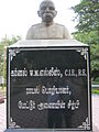
Architect of Mettur Dam Colonel W.M.Ellis,C.I.E,R.E 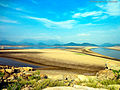
Mettur Pannavadi Nandhi statue and Jalagandeswarar temple submerged into Stanley Reservoir 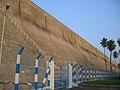
Mettur Dam View from Base 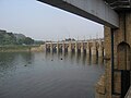
Mettur Dam - Overflow Bridge 
Specification board of Mettur dam 
Sluices channels for water draining by the side of the Mettur dam(Low level & High level sluices) 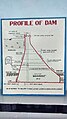
Dam Profile 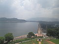
Dam Aerial View from the Platinum Jubilee Watch Tower


See also[]
- Banasura Sagar Dam
- Stanley Reservoir
- Krishna Raja Sagara
- Grand Anicut
Notes[]
- ^ "Mettur Dam". Archived from the original on 19 August 2006. Retrieved 22 November 2006.
- ^ a b "File:Specification board of Mettur dam.jpg - Wikimedia Commons". commons.wikimedia.org. Retrieved 4 January 2022.
- ^ Parsons, Michael (14 May 2016). "The Cork house that time forgot". The Irish Times.
- ^ "Mettur Dam completes 74 years. Do you know how we struggled before building the dam with Mysore Mettur Dam To Mysore On the way Reached Kolathur,..., India". Just91.com. Archived from the original on 3 January 2011. Retrieved 14 January 2011.
- ^ "Inter-state Water Disputes". Water Ministry - Government of India. Archived from the original on 12 February 2007. Retrieved 23 November 2006.
External links[]
| Wikimedia Commons has media related to Mettur Dam. |
- Dams in Tamil Nadu
- Kaveri River
- Salem district
- Hydroelectric power stations in Tamil Nadu
- Dams completed in 1934
- Dams on the Kaveri River
- 1934 establishments in India
- Tourist attractions in Salem district