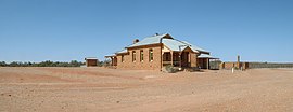
Milparinka, New South Wales
This article needs additional citations for verification. (January 2007) |
| Milparinka New South Wales | |||||||||
|---|---|---|---|---|---|---|---|---|---|
 Historic buildings at Milparinka | |||||||||
 Milparinka | |||||||||
| Coordinates | 29°43′55″S 141°52′05″E / 29.732°S 141.868°ECoordinates: 29°43′55″S 141°52′05″E / 29.732°S 141.868°E | ||||||||
| Population | 77 (2016 census)[1] | ||||||||
| Established | 1880 | ||||||||
| Location |
| ||||||||
| LGA(s) | Unincorporated Far West Region | ||||||||
| County | Evelyn | ||||||||
| State electorate(s) | Barwon | ||||||||
| Federal division(s) | Parkes | ||||||||
| |||||||||
Milparinka is a small settlement in north-west New South Wales, Australia, about 250 kilometres (155 mi) north of Broken Hill on the Silver City Highway. At the time of the 2016 census, Milparinka had a population of 77 people.[1] Milparinka is on Evelyn Creek.[2]
Summer temperatures can reach 50 °C (122 °F).
History[]
In 1844, Charles Sturt's expedition was stranded for six months at nearby Preservation Creek, owing to a lack of supplies.
Gold was discovered in the 1870s and a rush commenced in 1880. The mostly-male population peaked at 3,000, with W.H.J. Slee being appointed the resident Goldfields Warden in January 1881. Cobb & Co coaches ran three times a week from Milparinka to Wilcannia on the Darling River (the closest settlement, as Broken Hill did not yet exist) and by August 1881 the official gold escort had carried about 10,000 ounces of gold from the field, not to mention that which went privately.[3]

In this arid region, water was so scarce that miners collected their gold by dry blowing. Water was selling for one shilling per bucket and dysentery was rife, until in September 1881, on the recommendation of W.H.J. Slee, the New South Wales government authorised the drilling of a well.[4] In December 1881, the government well struck water at 140 feet, which caused great relief to all.[5][6]
At its height, Milparinka had a newspaper, a police office, a chemist shop, two butchers, a courthouse (1886), a school (1883), a hospital (1889) and four hotels.[7] There was drought in 1884.[8]
In June 1902, a large meteorite landed at nearby Mt Brown.[9]
Heritage listings[]
The ruins of the Albert Goldfield are listed on the New South Wales State Heritage Register.[10]
Notes and references[]
- ^ a b Australian Bureau of Statistics (27 June 2017). "Milparinka (State Suburb)". 2016 Census QuickStats. Retrieved 1 December 2017.

- ^ a b "Milparinka". The Family Hotel, Tibooburra. Archived from the original on 5 September 2009. Retrieved 5 January 2015.
- ^ "News of the Day". Sydney Morning Herald. 11 February 1882. p. 5.
- ^ "Mount Browne diggings". The Argus. Melbourne. 22 September 1881. p. 7.
- ^ "Intercolonial Telegrams". The Argus. Melbourne. 30 December 1881. p. 5.
- ^ McQueen, Ken (2007). "A thirsty and confusing diggings: the Albert Goldfield, Milparinka-Tibooburra, north-western NSW". Journal of Australasian Mining History. 5 (Sep 2007): 67–96.
- ^ "Milparinka". Sydney Morning Herald. 8 February 2004.
- ^ "The Albert Gold-fields". The Sydney Morning Herald. 18 August 1884. p. 8.
- ^ Ramdohr, Paul (1973), The Opaque Minerals in Stony Meteorite
- ^ "Albert Goldfield / Warratta Town". New South Wales State Heritage Register. Office of Environment and Heritage. H00975. Retrieved 2 June 2018.
External links[]
- Official website for more information about Milparinka and the district
| Wikimedia Commons has media related to Milparinka, New South Wales. |
- Towns in New South Wales
- Milparinka, New South Wales
- Mining towns in New South Wales
- Parishes of Evelyn County
- Unincorporated Far West Region
- New South Wales geography stubs
