Mingora
This article needs additional citations for verification. (April 2018) |
Mingora
| |
|---|---|
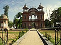
 View of Mingora | |
 Mingora | |
| Coordinates: 34°46′18″N 72°21′36″E / 34.77167°N 72.36000°ECoordinates: 34°46′18″N 72°21′36″E / 34.77167°N 72.36000°E | |
| Country | |
| Province | |
| Division | Malakand |
| District | Swat |
| Tehsil | Babuzai |
| Elevation | 984 m (3,228 ft) |
| Population | |
| • City | 331,091 |
| • Rank | 26th, Pakistan; 3rd, Khyber Pakhtunkhwa |
| Time zone | UTC+5 (PST) |
| Calling code | (0946) |
| Website | Mingora |


Mingora (Pashto: مینګورہ, Mingawara; Urdu: مینگورہ) is a city in the Swat District of Khyber Pakhtunkhwa, Pakistan. Located on the Swat River, it is the 3rd largest city in Khyber Pakhtunkhwa and the 26th largest in Pakistan. Mingora is the largest city and the epicenter of social, cultural, and economic activities in Malakand Division, and also the largest in the northern part of Khyber Pakhtunkhwa.[2]
History[]

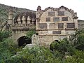
The area around Mingora has long been inhabited.[3] At Loe Banr, Butkara II and Matalai, Italian archaeologists unearthed 475 Indo-Aryan graves dated between 1520 and 170 BC and two horse skeletons.[4] On the opposite side of the River Swat at Aligrama, near the Saidu Sharif airport, a site of Gandhara grave culture was discovered by Italian archaeologists and dated to 1000 BC.
Buddhism arose in the region with the arrival of monks from the Gangetic plains. Under Emperor Ashoka, Buddhism became firmly established in the region, and the region became a launching ground for Ashoka's expansion of Buddhist missionaries to the western regions from the Mediterranean and West Asia. Many Buddhist remains and carvings[5] have been discovered near Mingora in the Jambil River Valley. At Panr, a stupa and monastery dated to the 1st century CE has been excavated. In Mingora, Faxian claimed to have seen the biggest Buddhist monastery, and large carving of the foot-prints of Buddha carved on the sides of the ridges at Teerat.[6] Excavations at the Butkara Stupa near Mingora revealed a large and imposing central stupa surrounded by more than 200 votive stupas which were discovered by Pakistani archeologist in the 20th century.[7] while the tomb of Akand of Swat, a local Buddhist ruler, and the archaeological remains of the Butkara Buddhist stupa were discovered during the British era.[8]
Following the collapse of Buddhist rule, direct control of the area came under the Hindu Shahis. Their rule marked the assent of Hinduism and Hindu polity in the region once again, after centuries of Buddhist rule and domination of the area.[9] Their rule came to an end with the rise of the Islamic empire of Mahmud Ghazni.
In 2007 during the rise of the Taliban insurgency, Mingora was invaded by the Taliban, largely impacting traditional culture in Mingora. A year later, the militant leader Fazlullah, then leader of Tehreek-e-Nafaz-e-Shariat-e-Mohammadi, established a pirated FM channel in the nearby Mamdheri village, approximately five kilometers away from Mingora.[2] Fazlullah subsequently became leader of Tehrik-i-Taliban Pakistan in Swat Valley, encompassing the entirety of Mingora.[10][11] The oppression of girls' education, Polio treatments, and freedom of expression became imminent throughout Mingora as a result, causing challenges for residents. Mingora's Green Square, once the hub of Mingora's social and cultural functions, became the execution grounds of Taliban opponents and dissidents, government officials, and civil workers, with corpses being hanged from electricity poles.[2] Shabana, a local singer and dancer, was brutally shot and killed by the Taliban with her body being dumped in Mingora's main roundabout.[12] In 2008, a suicide bomber killed about 40 people at a funeral.
The Operation Rah-e-Raast in 2009 placed Mingora back into Pakistani control.[13]
Climate[]


Mingora features a humid subtropical climate (Cfa) under the Köppen climate classification. The average annual temperature in Mingora is 19.3 °C, while the annual precipitation averages 897 mm. November is the driest month with 22 mm of precipitation, while August, the wettest month, has an average precipitation of 134 mm.
June is the hottest month of the year with an average temperature of 29.2 °C. The coldest month January has an average temperature of 7.6 °C.
| Climate data for Mingora | |||||||||||||
|---|---|---|---|---|---|---|---|---|---|---|---|---|---|
| Month | Jan | Feb | Mar | Apr | May | Jun | Jul | Aug | Sep | Oct | Nov | Dec | Year |
| Average high °C (°F) | 13.0 (55.4) |
15.8 (60.4) |
20.2 (68.4) |
25.6 (78.1) |
31.7 (89.1) |
36.8 (98.2) |
35.4 (95.7) |
33.7 (92.7) |
32.3 (90.1) |
28.0 (82.4) |
21.8 (71.2) |
15.3 (59.5) |
25.8 (78.4) |
| Daily mean °C (°F) | 7.6 (45.7) |
10.3 (50.5) |
14.2 (57.6) |
19.2 (66.6) |
24.5 (76.1) |
29.2 (84.6) |
29.0 (84.2) |
27.8 (82.0) |
25.6 (78.1) |
20.5 (68.9) |
14.6 (58.3) |
9.4 (48.9) |
19.3 (66.8) |
| Average low °C (°F) | 2.1 (35.8) |
4.8 (40.6) |
8.2 (46.8) |
12.7 (54.9) |
17.3 (63.1) |
21.6 (70.9) |
22.6 (72.7) |
21.9 (71.4) |
18.9 (66.0) |
12.9 (55.2) |
7.4 (45.3) |
3.5 (38.3) |
12.8 (55.1) |
| Average rainfall mm (inches) | 81 (3.2) |
98 (3.9) |
125 (4.9) |
90 (3.5) |
46 (1.8) |
31 (1.2) |
130 (5.1) |
134 (5.3) |
64 (2.5) |
28 (1.1) |
22 (0.9) |
48 (1.9) |
897 (35.3) |
| Source: Climate-Data.org[14] | |||||||||||||
Notable people[]
- , Badshah sahib Founder of The Swat State.
- Nazia Iqbal, Pashto singer
- Ghazala Javed (1988-2012), Pashto singer
- Nasir-ul-Mulk, former Pakistani Chief Justice
- Malala, Social Activist
See also[]
References[]
- ^ "POPULATION AND HOUSEHOLD DETAIL FROM BLOCK TO DISTRICT LEVEL: KHYBER PAKHTUNKHWA (SWAT DISTRICT)" (PDF). Pakistan Bureau of Statistics. 2018-01-03. Archived from the original (PDF) on 2018-04-17. Retrieved 2018-04-24.
- ^ a b c "Life in the Swat Valley". Pulitzer Center. 2011-08-05. Retrieved 2019-08-25.
- ^ Malik, Ahmad Rashid (3 September 2008). Pakistan-Japan Relations: Continuity and Change in Economic Relations and Security Interests. ISBN 9781134041961.
- ^ Augusto Azzaroli, Two Proto-historic Horse Skeletons from Swāt, Pakistan, East and West, Vol. 25, No. 3/4 (September–December 1975), pp. 353-357: [1]
- ^ https://korbah.com/carvings
- ^ "Journal of Asian Civilisations". 2001.
- ^ Khan, F. A. (1969). "Architecture and Art Treasures in Pakistan: Prehistoric, Protohistoric, Buddhist, and Hindu Periods".
- ^ "1998 District Census Report of [name of District].: Ghotki". 1999.
- ^ (Pakistan), Census Organization (1975). "Population Census of Pakistan, 1972: Sukkur".
- ^ Tribune.com.pk (2011-10-17). "Mullah Radio: Pakistan urges Afghan action against Maulvi Fazlullah". The Express Tribune. Retrieved 2019-08-25.
- ^ "Swat Taliban chief 'near death'". 2009-07-10. Retrieved 2019-08-25.
- ^ Jul 22, Omer Farooq Khan | TNN | Updated; 2009; Ist, 0:40. "Dying notes: Music goes out of Peshawar as artists face militants' ire - Times of India". The Times of India. Retrieved 2019-08-25.CS1 maint: numeric names: authors list (link)
- ^ "Operation Rah-e-Raast liberating Swat valley from extremism – South Asia Journal". Retrieved 2019-08-25.
- ^ "Climate: Mingora - Climate-Data.org". Retrieved 15 September 2016.
External links[]
Largest cities or towns in Khyber Pakhtunkhwa | |||||||||||||||||||||||||||||||||||||||||||||||||
|---|---|---|---|---|---|---|---|---|---|---|---|---|---|---|---|---|---|---|---|---|---|---|---|---|---|---|---|---|---|---|---|---|---|---|---|---|---|---|---|---|---|---|---|---|---|---|---|---|---|
| |||||||||||||||||||||||||||||||||||||||||||||||||


Authority control | |
|---|---|
| General |
|
| National libraries | |
- Cities in Khyber Pakhtunkhwa
- Populated places in Swat District