Montan
Montan | |
|---|---|
| Gemeinde Montan Comune di Montagna | |
show Location of Montan | |
 Montan Location of Montan in Italy | |
| Coordinates: 46°20′N 11°18′E / 46.333°N 11.300°ECoordinates: 46°20′N 11°18′E / 46.333°N 11.300°E | |
| Country | Italy |
| Region | Trentino-Alto Adige/Südtirol |
| Province | South Tyrol (BZ) |
| Frazioni | Glen (Gleno), Gschnon (Casignano), Kaltenbrunn (Fontanefredde), Pinzon (Pinzano) |
| Government | |
| • Mayor | Monika Delvai (SVP) |
| Area | |
| • Total | 18.9 km2 (7.3 sq mi) |
| Population (Nov. 2010)[2] | |
| • Total | 1,634 |
| • Density | 86/km2 (220/sq mi) |
| Demonym(s) | German: Montaner Italian: montagnesi |
| Time zone | UTC+1 (CET) |
| • Summer (DST) | UTC+2 (CEST) |
| Postal code | 39040 |
| Dialing code | 0471 |
| Patron saint | Bartholomew |
| Saint day | 24 August |
| Website | Official website |


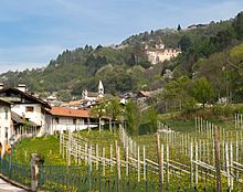
Montan (German pronunciation: [mɔnˈtaˑn]; Italian: Montagna [monˈtaɲɲa]) is a municipality with 1,701 inhabitants (as of 31 December 2018) in the South of South Tyrol in northern Italy, about 15 km (9.3 miles) south of Bolzano. The name Montan comes from the Latin mons ("mountain"). The charming hillside location and surroundings – with a panoramic view of the valley below, lake Kaltern and the Mendel ridge – has brought tourism to the village, which also boasts some old town houses.
Geography[]
The broad Cislon ridge with Montan, on a terrace, in front of it, as seen from the opposite Western side of the valley. The municipality of Montan, totalling 18.91 km2 (7.30 square miles), extends on the orographically left, i.e. eastern flank of the South Tyrolean Lowlands (Unterland), as the section of the Adige valley between Bolzano and the Salorno chasm is called. The main settlement areas are located on a wide hillside terrace, on which sits the main town of Montan (390–530 m or 1,280–1,740 feet); somewhat south of it lie the two districts Pinzon (390–430 m or 1,280–1,410 feet) and Glen (520–580 m or 1,710–1,900 feet). The Castelfeder hill (405 m or 1,329 feet) between Neumarkt and Auer protrudes west of the main town into the Adige valley. Below the hill, the municipality of Montan also occupies a small part of the valley floor up to the Adige river.
To the east of the main town, the terrain rises to the Cislon (1,563 m or 5,128 feet), a ridge of the forested mountain range that is part of the Fiemme Valley, which separates Unterland from Fiemme. This vast majority of this ridge is part of the protected Trudner Horn Nature Park and borders on the municipality of Truden. To the North, the Schwarzenbach valley forms the border to Aldein; here, a narrow strip of the municipality encloses parts of Kaltenbrunn (970–1,000 m or 3,180–3,280 feet). In the south, another strip of territory crosses the Truden stream valley and – bordering Neumarkt, Salorno, Truden and Capriana in Trentino – occupies the northwestern slopes of the Trudner Horn (1,781 m or 5,843 feet), where the small settlement of Gschnon (930–960 m or 3,050–3,150 feet) is located.
Frazioni[]
The municipality of Montan contains the frazioni (subdivisions, mainly villages and hamlets) Glen (Gleno), Gschnon (Casignano), Kaltenbrunn (Fontanefredde), Kalditsch (Doladizza), and Pinzon (Pinzano).
Coat-of-arms[]
The emblem represents an argent lion, with fixed eyes and claws of or, on azure. It is the arms of the Lords of Enn who built the Castle in the twelfth century. The emblem was granted in 1967.[3]
History[]
Finds from the pre-Christian area show that early settlements in the Montan area date back to that period. Results from linguistics research in the field of place and field names support this assumption. Local names of pre-Roman (Gomaroa, Tschalfai) and Romanesque (Kalditsch, Montan, Glen, Pinzon) origin suggest a lively settlement activity in the centuries BC and AD.[4] Around 955, Bavarian settlers began colonising the area. This colonisation culminated in the 12th century and ended in the mid-13th century. In 1133, the possession of the Weyarn monastery was registered at Enn court, as was the Sonnenburg monastery in Kalditsch in 1181. The lords of Enn made their first appearance in Montan in the mid-12th century. In 1435, Pastor Hans Hach of Montan ("her Hans Hach pharrer zu Montæny") was a member of the South Tyrolean priesthood, which pledged to hold the Austrian anniversary in Holy Mary parish church in Bozen.[5] Until the end of the First World War, Montan belonged to the county of Tyrol and thus to the Austro-Hungarian empire. Within Tyrol, Montan was assigned to the Neumarkt judicial district, which in turn was part of the Bozen district. With the Treaty of Saint-Germain, Montan, along with most of Tyrol south of the main ridge of the Alps, was ceded to Italy in 1920. When these former Austrian territories became the two provinces of Bozen and Trento in 1927, Montan and other surrounding villages were assigned to the predominantly Italian-speaking province of Trento. It wasn't until 1948 that Montan became again part of the Province of Bozen/South Tyrol.
Demographic evolution[]

Linguistic distribution[]
According to the 2011 census, 92.54% of the population speak German, 6.94% Italian and 0.52% Ladin as first language.[6]
Education[]
There is a German-language primary school in Montan, which is part of the school district of the neighbouring municipality of Auer.
Politics[]
Head of the municipality:[7][8][9][10][11]
- Michael Rizzolli: 1855, 1857
- Franz Weissensteiner: 1866
- Josef Wegscheider: 1886–1888
- Emil Leys-Paschbach: 1888–1918
- Franz March: 1918–1922
- Jakob Pichler: 1922–1924
Acting Mayor:
- Alois Pernter: 1943–1945
- Jakob Pichler: 1945–1952
Mayors since 1952:[12]
- Alfred March: 1952–1964
- Josef Wegscheider: 1964–1980
- Otto Nussbaumer: 1980–1990
- Alois Amort: 1990–2010
- Monika Delvai: since 2010
Sights[]
- Castelfeder is a prehistoric and Roman settlement on a strategically important porphyry hill near Montan (South Tyrol) above Auer and represents a multi-sectioned, spacious dome. The upper “fortress” rises around 190 m (620 feet) above the valley floor and is located at 405 m (1,329 feet) above sea level.
- Enn castle
- Hans-Klocker altar, a winged altar by master Hans Klocker from Brixen in the St. Stefan church in Pinzon

- The cemetery holds the tomb of the Italian nationalist Ettore Tolomei (1865–1952), who was known in South Tyrol as the “gravedigger of South Tyrol”. In 1905, Tolomei acquired the Thalerhof in the hamlet of Glen and moved there in 1906. At the beginning of the First World War in 1914, Tolomei left Montan and moved to Rome, where he promoted and organised the annexation by Italy of the Italian Tyrol and South Tyrol up to the Brenner border. Repeatedly, Italian neo-fascist politicians and organizations laying wreaths and rallying at Tolomei's tomb have been causing public outrage. Today the tomb is guarded by the Carabinieri, as it had been repeatedly damaged by South Tyrol activists in the past. At the beginning of the 1960s, a bomb attack was even carried out on the Thalerhof farm.
- The former Fleimstal railway track is a popular destination for hikers in Montan. This railway line was built during the First World War. The route begins in Auer and originally led to Predazzo. A popular cycling and hiking trail now follows the very well-preserved section between Auer and San Lugano. Especially between Montan and Glen section the view over the South Tyrol lowlands is excellent.
Important persons[]
- Emil Leys-Paschbach (born 12 April 1853 in Vienna, † 21 February 1927 in Montan), politician and economist
Twin cities / associated cities[]
References[]
- ^ "Superficie di Comuni Province e Regioni italiane al 9 ottobre 2011". Istat. Retrieved 16 March 2019.
- ^ "Popolazione Residente al 1° Gennaio 2018". Istat. Retrieved 16 March 2019.
- ^ Heraldry of the World: Montan
- ^ Haidacher, Christoph, Schützenkompanie Montan (ed.), Montan (in German), p. 114
- ^ Obermair, Hannes (2008), Bozen Süd – Bolzano Nord. Schriftlichkeit und urkundliche Überlieferung der Stadt Bozen bis 1500 (in German), 2, Bozen: Stadtgemeinde Bozen, p. 78, ISBN 978-88-901870-1-8CS1 maint: date and year (link)
- ^ "Volkszählung 2011/Censimento della popolazione 2011". Astat Info. Provincial Statistics Institute of the Autonomous Province of South Tyrol (38): 6–7. June 2012. Retrieved 14 June 2012.
- ^ Tiroler Volksbote (in German), 22 November 1922, p. 7
- ^ Meraner Zeitung (in German), 31 January 1918, p. 5
- ^ Tiroler Volksblatt (in German), 9 January 1886, p. 3
- ^ Bozner Zeitung (in German), 10 January 1855, p. 3
- ^ Der Bote für Tirol (in German), 6 December 1866, p. 2
- ^ "Die Bürgermeister der Gemeinden Südtirols seit 1952" (PDF). Festschrift 50 Jahre Südtiroler Gemeindeverband 1954–2004. Südtiroler Gemeindenverband. pp. 139–159. Retrieved 16 November 2015.
- ^ Nürnberg International - Informationen zu den Auslandsbeziehungen der Stadt Nürnberg
External links[]
![]() Media related to Montan at Wikimedia Commons
Media related to Montan at Wikimedia Commons
- (in German and Italian) Homepage of the municipality
- (in German and Italian) Homepage of Montan

| show Authority control |
|---|
- Municipalities of South Tyrol