Montauriol, Aude
show This article may be expanded with text translated from the corresponding article in French. (December 2008) Click [show] for important translation instructions. |
Montauriol | |
|---|---|
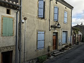 The town hall in Montauriol | |
 Coat of arms | |
show Location of Montauriol | |
 Montauriol | |
| Coordinates: 43°16′43″N 1°50′11″E / 43.2786°N 1.8364°ECoordinates: 43°16′43″N 1°50′11″E / 43.2786°N 1.8364°E | |
| Country | France |
| Region | Occitanie |
| Department | Aude |
| Arrondissement | Carcassonne |
| Canton | La Piège au Razès |
| Government | |
| • Mayor (2020–2026) | Alain Carbon |
| Area 1 | 8.47 km2 (3.27 sq mi) |
| Population (Jan. 2018)[1] | 84 |
| • Density | 9.9/km2 (26/sq mi) |
| Time zone | UTC+01:00 (CET) |
| • Summer (DST) | UTC+02:00 (CEST) |
| INSEE/Postal code | 11239 /11410 |
| Elevation | 225–313 m (738–1,027 ft) (avg. 252 m or 827 ft) |
| 1 French Land Register data, which excludes lakes, ponds, glaciers > 1 km2 (0.386 sq mi or 247 acres) and river estuaries. | |


Montauriol (French pronunciation: [mɔ̃toʁjɔl] (![]() listen); Occitan: Montauriòl) is a commune in the Aude department in southern France.
listen); Occitan: Montauriòl) is a commune in the Aude department in southern France.
Population[]
| Year | Pop. | ±% |
|---|---|---|
| 1962 | 73 | — |
| 1968 | 93 | +27.4% |
| 1975 | 74 | −20.4% |
| 1982 | 74 | +0.0% |
| 1990 | 75 | +1.4% |
| 1999 | 74 | −1.3% |
| 2008 | 78 | +5.4% |
See also[]
- Communes of the Aude department
References[]
- ^ "Populations légales 2018". INSEE. 28 December 2020.
| Wikimedia Commons has media related to Montauriol, Aude. |
| show Communes of the Aude department |
|---|
This Aude geographical article is a stub. You can help Wikipedia by . |
Categories:
- Communes of Aude
- Aude geography stubs