Montlake Cut
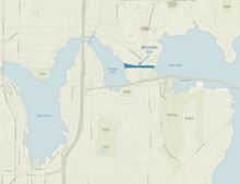


The Montlake Cut is the easternmost section of the Lake Washington Ship Canal, which passes through the city of Seattle, linking Lake Washington to Puget Sound. It was completed in 1916 and is approximately 2,500 feet (760 m) long and 350 feet (110 m) wide. The center channel is 100 feet (30 m) wide and 30 feet (9.1 m) deep. The path along the cut was designated a National Recreation Trail as Montlake Cut National Waterside in 1971.[1]
The Cut provides a connection between Union Bay, part of Lake Washington, to the east and Portage Bay, an arm of Lake Union, to the west. It is spanned by the Montlake Bridge, a bascule drawbridge carrying Montlake Boulevard (State Route 513). Most of the land on the north shore of the Cut is occupied by the University of Washington, its medical school to the west and its stadium parking lot to the east; residences and a recreational trail occupy the south bank, which is part of the Montlake neighborhood. It is the site of the annual Windermere Cup crew regatta and the 's Opening Day Boat Parade, both of which take place on the first Saturday in May.
The cut lowered the water level of Lake Washington by 8.8 feet, drained the wetlands around the lake, and lowered the lake below the outflow at the Black River (at the south end of the lake in Renton).[2]
The Montlake Cut's original name was Erickson Cut. Contractor C.J. Erickson commenced the big project in turning on his big steam shovel in celebration of the October 27, 1909, post A-Y-P Exposition era, in the final push to complete the Lake Washington Canal project. At the ceremony were Judge Roger S. Greene, Judge Thomas Burke, J.S. Brace and John H. McGraw who turned the first shovel of dirt that day.
The Duwamish called the area "Carry a Canoe" (Lushootseed: sxWátSadweehL). Indigenous people had been portaging between the lakes for centuries, either carrying canoes or shoving them along an intermittent creek that appeared when Lake Washington overflowed.[3]
"The Cut" is home to the University of Washington Rowing Teams, serving as the final 500 meters of the 2000 meter race course.
References[]
- ^ "Montlake Cut National Waterside". American Trails. 2013-05-15. Retrieved 2014-08-14.
- ^ historylink.org
- ^ Thrush, Coll (2007). Native Seattle: Histories from the Crossing-Over Place. University of Washington Press. p. 251. ISBN 0-295-98700-6.
External links[]
| Wikimedia Commons has media related to Montlake Cut. |
Coordinates: 47°38′50″N 122°18′16″W / 47.64718°N 122.30435°W

- Buildings and structures in Seattle
- Water transport in Seattle
- Montlake, Seattle