Moorefield Township, Harrison County, Ohio
Moorefield Township, Harrison County, Ohio | |
|---|---|
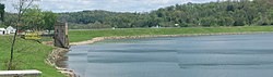 Piedmont Lake dam is alongside U.S. Route 22. | |
 Location of Moorefield Township in Harrison County | |
| Coordinates: 40°11′45″N 81°9′40″W / 40.19583°N 81.16111°WCoordinates: 40°11′45″N 81°9′40″W / 40.19583°N 81.16111°W | |
| Country | United States |
| State | Ohio |
| County | Harrison |
| Area | |
| • Total | 27.5 sq mi (71.3 km2) |
| • Land | 26.9 sq mi (69.6 km2) |
| • Water | 0.7 sq mi (1.7 km2) |
| Elevation | 1,099 ft (335 m) |
| Population (2010) | |
| • Total | 403 |
| • Density | 15/sq mi (5.8/km2) |
| Time zone | UTC-5 (Eastern (EST)) |
| • Summer (DST) | UTC-4 (EDT) |
| ZIP code | 43907 |
| Area code(s) | 740 |
| FIPS code | 39-51940[2] |
| GNIS feature ID | 1086279[1] |

Moorefield Township is one of the fifteen townships of Harrison County, Ohio, United States. As of the 2010 census the population was 403.[3]
Geography[]
Located in the southern part of the county, it borders the following townships:
- Nottingham Township - north
- Cadiz Township - northeast
- Athens Township - east
- Flushing Township, Belmont County - south
- Freeport Township - west
- Washington Township - northwest
No municipalities are located in Moorefield Township, although the unincorporated community of Piedmont lies in the western part of the township.
Name and history[]
Statewide, the only other Moorefield Township is located in Clark County.
Government[]
The township is governed by a three-member board of trustees, who are elected in November of odd-numbered years to a four-year term beginning on the following January 1. Two are elected in the year after the presidential election and one is elected in the year before it. There is also an elected township fiscal officer,[4] who serves a four-year term beginning on April 1 of the year after the election, which is held in November of the year before the presidential election. Vacancies in the fiscal officership or on the board of trustees are filled by the remaining trustees.
References[]
- ^ Jump up to: a b "US Board on Geographic Names". United States Geological Survey. 2007-10-25. Retrieved 2008-01-31.
- ^ "U.S. Census website". United States Census Bureau. Retrieved 2008-01-31.
- ^ "Geographic Identifiers: 2010 Census Summary File 1 (G001): Moorefield township, Harrison County, Ohio". American Factfinder. U.S. Census Bureau. Archived from the original on February 13, 2020. Retrieved December 29, 2017.
- ^ §503.24, §505.01, and §507.01 of the Ohio Revised Code. Accessed 4/30/2009.
External links[]
| show Municipalities and communities of Harrison County, Ohio, United States |
|---|

| show Authority control |
|---|
- Townships in Harrison County, Ohio
- Townships in Ohio