Moosthenning
show This article may be expanded with text translated from the corresponding article in German. (March 2009) Click [show] for important translation instructions. |
Moosthenning | |
|---|---|
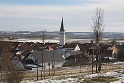 View towards Moosthenning | |
 Coat of arms | |
show Location of Moosthenning within Dingolfing-Landau district | |
 Moosthenning | |
| Coordinates: 48°41′N 12°30′E / 48.683°N 12.500°ECoordinates: 48°41′N 12°30′E / 48.683°N 12.500°E | |
| Country | Germany |
| State | Bavaria |
| Admin. region | Niederbayern |
| District | Dingolfing-Landau |
| Subdivisions | 6 Ortsteile |
| Government | |
| • Mayor (2020–26) | Anton Kargel[1] |
| Area | |
| • Total | 70.40 km2 (27.18 sq mi) |
| Elevation | 368 m (1,207 ft) |
| Population (2020-12-31)[2] | |
| • Total | 4,933 |
| • Density | 70/km2 (180/sq mi) |
| Time zone | UTC+01:00 (CET) |
| • Summer (DST) | UTC+02:00 (CEST) |
| Postal codes | 84164 |
| Dialling codes | 08731 |
| Vehicle registration | DGF |
| Website | www |


Moosthenning (Bavarian: Moosdenning) is a municipality in the district of Dingolfing-Landau in Bavaria in Germany.
References[]
- ^ Liste der ersten Bürgermeister/Oberbürgermeister in kreisangehörigen Gemeinden, Bayerisches Landesamt für Statistik, 15 July 2021.
- ^ "Tabellenblatt "Daten 2", Statistischer Bericht A1200C 202041 Einwohnerzahlen der Gemeinden, Kreise und Regierungsbezirke". Bayerisches Landesamt für Statistik (in German). June 2021.
| show Towns and municipalities in Dingolfing-Landau |
|---|
| Authority control |
|---|
This Dingolfing-Landau location article is a stub. You can help Wikipedia by . |
Categories:
- Municipalities in Bavaria
- Dingolfing-Landau
- Lower Bavaria geography stubs