Reisbach (Vils)
show This article may be expanded with text translated from the corresponding article in German. (March 2009) Click [show] for important translation instructions. |
Reisbach | |
|---|---|
 Town hall | |
 Coat of arms | |
show Location of Reisbach within Dingolfing-Landau district | |
 Reisbach | |
| Coordinates: 48°34′N 12°38′E / 48.567°N 12.633°ECoordinates: 48°34′N 12°38′E / 48.567°N 12.633°E | |
| Country | Germany |
| State | Bavaria |
| Admin. region | Niederbayern |
| District | Dingolfing-Landau |
| Subdivisions | 7 Ortsteile |
| Government | |
| • Mayor (2020–26) | Rolf-Peter Holzleitner [1] (FW) |
| Area | |
| • Total | 94.16 km2 (36.36 sq mi) |
| Elevation | 408 m (1,339 ft) |
| Population (2020-12-31)[2] | |
| • Total | 7,831 |
| • Density | 83/km2 (220/sq mi) |
| Time zone | UTC+01:00 (CET) |
| • Summer (DST) | UTC+02:00 (CEST) |
| Postal codes | 94419 |
| Dialling codes | 08734 08735 () |
| Vehicle registration | DGF |
| Website | www |


Reisbach is a market town in Bavaria. It lies on the Vils River, and belongs to the administrative region of Niederbayern.
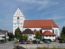 Church of St. Michael |
Neighbouring communities[]
The neighbouring communities, listed clockwise, are Mamming, Landau an der Isar, Simbach (bei Landau), Falkenberg (Niederbayern), Rimbach (Niederbayern), Gangkofen, Marklkofen and Gottfrieding.
| show Places adjacent to Reisbach (Vils) |
|---|
Villages in the municipality[]
- Englmannsberg
- Griesbach
- Niederhausen
- Oberhausen
- Obermünchsdorf
- Reith
- Thannenmais
References[]
- ^ Liste der ersten Bürgermeister/Oberbürgermeister in kreisangehörigen Gemeinden, Bayerisches Landesamt für Statistik, 15 July 2021.
- ^ "Tabellenblatt "Daten 2", Statistischer Bericht A1200C 202041 Einwohnerzahlen der Gemeinden, Kreise und Regierungsbezirke". Bayerisches Landesamt für Statistik (in German). June 2021.
| show Towns and municipalities in Dingolfing-Landau |
|---|
| show Authority control |
|---|
This Dingolfing-Landau location article is a stub. You can help Wikipedia by . |
Categories:
- Municipalities in Bavaria
- Dingolfing-Landau
- Lower Bavaria geography stubs