Mortagne (river)
| Mortagne | |
|---|---|
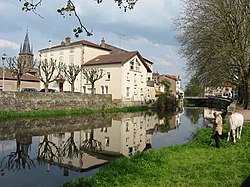 The Mortagne at Rambervillers | |
 | |
| Location | |
| Country | France |
| Region | Grand Est |
| Physical characteristics | |
| Source | |
| • location | Saint-Léonard |
| • coordinates | 48°12′49″N 06°52′23″E / 48.21361°N 6.87306°E |
| • elevation | 550 m (1,800 ft) |
| Mouth | |
• location | Meurthe |
• coordinates | 48°33′25″N 06°26′49″E / 48.55694°N 6.44694°ECoordinates: 48°33′25″N 06°26′49″E / 48.55694°N 6.44694°E |
• elevation | 215 m (705 ft) |
| Length | 74.6 km (46.4 mi) |
| Basin size | 582 km2 (225 sq mi) |
| Discharge | |
| • average | 6.72 m3/s (237 cu ft/s) |
| Basin features | |
| Progression | Meurthe→ Moselle→ Rhine→ North Sea |


The Mortagne (French: la Mortagne) is a 74.6-kilometre (46.4 mi) long river in the Vosges and Meurthe-et-Moselle départements, northeastern France.[1] Its source is at Saint-Léonard, 5 km (3.1 mi) west of the village, in the Vosges Mountains. It flows generally northwest. It is a left tributary of the Meurthe into which it flows at Mont-sur-Meurthe, 5 km (3.1 mi) southwest of Lunéville.
Communes along its course[]
This list is ordered from source to mouth:
- Vosges: Saint-Léonard, Taintrux, La Houssière, Bois-de-Champ, Les Rouges-Eaux, Mortagne, Domfaing, Brouvelieures, Fremifontaine, Autrey, Sainte-Hélène, Saint-Gorgon, Jeanménil, Rambervillers, Roville-aux-Chênes, Saint-Maurice-sur-Mortagne, Xaffévillers, Deinvillers
- Meurthe-et-Moselle: Magnières, Vallois, Moyen, Gerbéviller, Haudonville, Lamath, Xermaménil, Mont-sur-Meurthe
References[]
| Wikimedia Commons has media related to Mortagne (river). |
This Vosges geographical article is a stub. You can help Wikipedia by . |
This Meurthe-et-Moselle geographical article is a stub. You can help Wikipedia by . |
Categories:
- Tributaries of the Moselle
- Rivers of France
- Rivers of Vosges (department)
- Rivers of Meurthe-et-Moselle
- Rivers of Grand Est
- Vosges (department) geography stubs
- Meurthe-et-Moselle geography stubs
- France river stubs