Morton, Pennsylvania
Morton, Pennsylvania | |
|---|---|
Borough | |
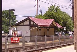 Morton SEPTA station | |
 Location in Delaware County and the U.S. state of Pennsylvania. | |
 Morton Location of Morton in Pennsylvania | |
| Coordinates: 39°54′38″N 75°19′38″W / 39.91056°N 75.32722°WCoordinates: 39°54′38″N 75°19′38″W / 39.91056°N 75.32722°W | |
| Country | United States |
| State | Pennsylvania |
| County | Delaware |
| Area | |
| • Total | 0.36 sq mi (0.93 km2) |
| • Land | 0.36 sq mi (0.93 km2) |
| • Water | 0.00 sq mi (0.00 km2) |
| Elevation | 141 ft (43 m) |
| Population (2010) | |
| • Total | 2,669 |
| • Estimate (2019)[2] | 2,670 |
| • Density | 7,458.10/sq mi (2,877.81/km2) |
| Time zone | UTC-5 (EST) |
| • Summer (DST) | UTC-4 (EDT) |
| ZIP code | 19070 |
| Area code(s) | 610 and 484 |
| FIPS code | 42-51176 |
| GNIS feature ID | 1181592 |
| Website | mortonpa |


Morton is a borough in Delaware County, Pennsylvania, United States. The population was 2,669 at the 2010 census.[3]
Geography[]
Morton is located in eastern Delaware County at 39°54′38″N 75°19′38″W / 39.91056°N 75.32722°W (39.910612, -75.327273).[4] It is bordered to the north, east, and west by Springfield Township and to the south by Ridley Township. Pennsylvania Route 420 (Woodland Avenue) passes through the borough, leading north 2.5 miles (4.0 km) to U.S. Route 1 in Springfield Township and south 3 miles (5 km) to Interstate 95 in Tinicum Township.
According to the United States Census Bureau, Morton has a total area of 0.36 square miles (0.93 km2), all of it land.[3]
Demographics[]
| Historical population | |||
|---|---|---|---|
| Census | Pop. | %± | |
| 1880 | 327 | — | |
| 1890 | 821 | 151.1% | |
| 1900 | 889 | 8.3% | |
| 1910 | 1,071 | 20.5% | |
| 1920 | 1,212 | 13.2% | |
| 1930 | 1,341 | 10.6% | |
| 1940 | 1,316 | −1.9% | |
| 1950 | 1,352 | 2.7% | |
| 1960 | 2,207 | 63.2% | |
| 1970 | 2,602 | 17.9% | |
| 1980 | 2,412 | −7.3% | |
| 1990 | 2,851 | 18.2% | |
| 2000 | 2,715 | −4.8% | |
| 2010 | 2,669 | −1.7% | |
| 2019 (est.) | 2,670 | [2] | 0.0% |
| Sources:[5][6][7] | |||
As of Census 2010, the racial makeup of the borough was 65.1% White, 25.4% African American, 0.3% Native American, 6.0% Asian, 0.6% from other races, and 2.7% from two or more races. Hispanic or Latino of any race were 2.2% of the population [1][dead link]. The current mayor is Jesse Weber, a well respected doctor, and former specialist for the CDC.
As of the census[6] of 2000, there were 2,715 people, 1,145 households, and 687 families residing in the borough. The population density was 7,502.4 people per square mile (2,911.9/km²). There were 1,209 housing units at an average density of 3,340.8 per square mile (1,296.7/km²). The racial makeup of the borough was 69.87% White, 24.46% African American, 0.07% Native American, 3.90% Asian, 0.33% from other races, and 1.36% from two or more races. Hispanic or Latino of any race were 1.14% of the population.
There were 1,145 households, out of which 27.6% had children under the age of 18 living with them, 40.9% were married couples living together, 14.7% had a female householder with no husband present, and 40.0% were non-families. 34.6% of all households were made up of individuals, and 11.3% had someone living alone who was 65 years of age or older. The average household size was 2.36 and the average family size was 3.10.
In the borough the population was spread out, with 23.1% under the age of 18, 8.5% from 18 to 24, 32.2% from 25 to 44, 20.8% from 45 to 64, and 15.4% who were 65 years of age or older. The median age was 38 years. For every 100 females there were 88.7 males. For every 100 females age 18 and over, there were 85.7 males.
The median income for a household in the borough was $46,731, and the median income for a family was $64,271. Males had a median income of $38,720 versus $34,940 for females. The per capita income for the borough was $25,408. About 4.4% of families and 6.4% of the population were below the poverty line, including 4.4% of those under age 18 and 3.8% of those age 65 or over.
History and prominent residents[]
Morton was named after Sketchley Morton, son of John Morton, a signer of the Declaration of Independence and the delegate who cast the deciding vote in favor of American independence. In 1776, Morton became part of Ridley Township and Springfield Township.[citation needed]
The borough houses the Morton train station, built in 1880[8] by Joseph Wilson of the Wilson Brothers architectural firm to serve the Morton stop on the Pennsylvania Railroad West Chester line that originated in 1854. It is currently used on the SEPTA Regional Rail Media/Elwyn Line.
The Piasecki Helicopter Corporation opened a manufacturing plant in Morton in 1947. The Piasecki H-21 and the Piasecki HUP-1 were both manufactured there. Boeing incorporated the company in 1960, and the company moved the manufacturing to a site along the Delaware River.[9] The original Piasecki building is now a BJ's Wholesale Club, with the control tower on one corner.[10]
Mike Scioscia, former Major League Baseball player with the Los Angeles Dodgers and former manager of the Los Angeles Angels, is a native of Morton.
Education[]
Morton lies within the Springfield School District, as well as the Ridley School District. The borough is served by Springfield Literacy Center (K-1), Sabold Elementary School (2-5), E.T. Richardson Middle School (6-8), and Springfield High School (9-12).
The former Sidney Smedley School is now the borough hall. It was constructed in 1914 and closed in June 1979.[11]
Our Lady of Angels Regional School in Morton, Ridley Township, is the area Catholic school. It formed in 2012 from a merger of Our Lady of Perpetual Help in Ridley Township and Our Lady of Fatima in Secane and in Ridley Township.[12]
References[]
- ^ "2019 U.S. Gazetteer Files". United States Census Bureau. Retrieved July 28, 2020.
- ^ Jump up to: a b "Population and Housing Unit Estimates". United States Census Bureau. May 24, 2020. Retrieved May 27, 2020.
- ^ Jump up to: a b "Geographic Identifiers: 2010 Demographic Profile Data (G001): Morton borough, Pennsylvania". U.S. Census Bureau, American Factfinder. Archived from the original on February 13, 2020. Retrieved December 28, 2015.
- ^ "US Gazetteer files: 2010, 2000, and 1990". United States Census Bureau. 2011-02-12. Retrieved 2011-04-23.
- ^ "Census of Population and Housing". U.S. Census Bureau. Retrieved 11 December 2013.
- ^ Jump up to: a b "U.S. Census website". United States Census Bureau. Retrieved 2008-01-31.
- ^ "Incorporated Places and Minor Civil Divisions Datasets: Subcounty Resident Population Estimates: April 1, 2010 to July 1, 2012". Population Estimates. U.S. Census Bureau. Archived from the original on 17 June 2013. Retrieved 11 December 2013.
- ^ "Archived copy". Archived from the original on 2009-08-09. Retrieved 2009-10-19.CS1 maint: archived copy as title (link)
- ^ http://www.boeing.com/news/frontiers/archive/2005/july/mainfeature.html
- ^ http://www.airfields-freeman.com/PA/Airfields_PA_Philly_S.htm
- ^ Springfield Historical Society (2004-06-23). Springfield Township, Delaware County. Arcadia Publishing. p. PT146. ISBN 9781439629017.
- ^ "2012 Catholic grade school consolidations/closings". Catholicphilly.com. 2012-07-15. Retrieved 2020-04-22.
External links[]
| hide Municipalities and communities of Delaware County, Pennsylvania, United States | ||
|---|---|---|
| City |  | |
| Boroughs | ||
| Townships | ||
| CDPs | ||
| Other communities |
| |
| Ghost town | ||
| Footnotes | ‡This populated place also has portions in an adjacent county or counties | |
| ||
- Populated places established in 1866
- Boroughs in Delaware County, Pennsylvania
- 1866 establishments in Pennsylvania