Moss Side
| Moss Side | |
|---|---|
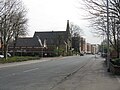
 Alexandra Park Estate in Moss Side, looking towards the Beetham Tower | |
 Moss Side Location within Greater Manchester | |
| Population | 18,902 (2011) |
| OS grid reference | SJ835955 |
| • London | 162 mi (261 km) SE |
| Metropolitan borough | |
| Metropolitan county |
|
| Region | |
| Country | England |
| Sovereign state | United Kingdom |
| Post town | MANCHESTER |
| Postcode district | M14, M16 |
| Dialling code | 0161 |
| Police | Greater Manchester |
| Fire | Greater Manchester |
| Ambulance | North West |
| UK Parliament | |
| Councillors |
|

Moss Side is an inner-city area of Manchester, England, 1.9 miles (3.1 km) south of the city centre, It had a population of 18,902 at the 2011 census.[1] Moss Side is bounded by Hulme to the north, Chorlton-on-Medlock, Rusholme and Fallowfield to the east, Whalley Range to the south, and Old Trafford to the west.
As well as Whitworth Park and Alexandra Park, Moss Side is close to Manchester and Manchester Metropolitan universities.[2] Manchester City played at Maine Road in Moss Side between 1923 and 2003.
History[]
Historically part of Lancashire, Moss Side was a rural township and chapelry within the parish of Manchester and hundred of Salford. Thought to be named after a great moss which stretched from Rusholme to Chorlton-cum-Hardy, the earliest mention of the area is in 1533 when it contained part of the estates of Trafford.[3] Moss Side is described in the opening chapter of Elizabeth Gaskell's Mary Barton as a rural idyll with a 'deep clear pool' and an old black and white timber-framed farmhouse, later identified as Pepperhill Farm.[3] Following the Industrial Revolution there was a process of unplanned urbanisation and a rapid increase in population size. The population in 1801 was 151 but by 1901 this had increased to 26,677.[3] The industrial growth of the area resulted in a densely populated area, so much so, that a part of the township of Moss Side was amalgamated into the expanding city of Manchester in 1885, with the rest joining in 1904.[4]
Mass development in Moss Side occurred in the late 19th and early 20th centuries when large numbers of red brick terraced houses were built, and soon attracted numerous Irish immigrants and other working people.
Manchester City F.C. moved to a new stadium on Maine Road on 25 August 1923, having moved from Hyde Road, Ardwick; on its opening it was one of the most capacious sports stadiums in the United Kingdom, capable of holding up to 85,000 spectators. The club would play there for the next 80 years.[5]

During the Manchester Blitz in the Second World War many of the terraced houses were damaged by German bombing on the night of 22/23 December 1940. Migrants from the Indian subcontinent and Caribbean settled in the locality during the 1950s and 1960s, and by the 1980s Moss Side was the hub of Manchester's Afro-Caribbean community.[6] During the 1960s and early 1970s, Manchester City Council demolished many of the Victorian and terraced houses to the west of Moss Side and replaced these with new council houses and flats. Most of the newer properties, built around the turn of the 20th century, were refurbished instead of demolished during the final two decades of the century.
In 1981, the Moss Side area was one of England's inner city areas affected by a series of riots. Analysts trace the 1970s origins of Manchester's gang crime to social deprivation in the south-central part of the city – Hulme, Longsight and Moss Side – where the activity of the underground economy encouraged a trade in illegal narcotics and firearms contributing to Manchester's later nickname of "Gunchester".[7] "Turf wars" between rival drugs 'gangs', resulted in a high number of fatal shootings.[6] During what has been termed the Madchester phase of the history of Manchester, narcotic trade in the city became "extremely lucrative" and in the early 1990s a gang war started between two groups vying for control of the market in Manchester city centre – the 'Cheetham Hill Gang' and 'The Gooch Close Gang', in Cheetham Hill and Moss Side, respectively.[8] There were several high-profile shootings associated with gangs and drugs in this area during the 1990s and into the 21st century.[7][9] Aided by the work of Xcalibre, the Greater Manchester Police's task force, founded in 2004, and the multiagency Integrated Gang Management Unit, gang related shootings in the area have fallen by about 90% in recent years.[10][11][12]
In April 1994, The Independent newspaper highlighted Moss Side as one of the most deprived areas on Britain, and as having some of the highest crime rates. Drug abuse was described as one of the area's biggest problems, with gun crime rates being so high that there had recently been 400 armed incidents reported within a 12-month period. Ambulance crews had resorted to wearing body armour after having to deal with a string of mostly drug-related shootings. Several doctors had been robbed of medical bags at knife point after being called out to local patients. A number of police vehicles had been fire-bombed and there had been reports of attempted ambushes on police patrols. Unemployment stood at nearly 30% – up to three times the national average in the early 1990s.[13]
Many of the flats in neighbouring Hulme were demolished in the early 1990s to make way for new low rise homes. Housing on the Alexandra Park Estate in the west of Moss Side has been renovated and the streets redesigned to reduce the fear of crime.[14]
Governance[]

The majority of Moss Side is part of the Manchester Central constituency, represented by the Labour Party MP Lucy Powell. Following boundary changes in 2018 a portion of the ward is a part of the Manchester Gorton constituency, represented by the Labour Party MP Afzal Khan.
- Councillors
Moss Side is a ward within the local authority of Manchester City Council. The ward is represented by Labour Councillors: Mahadi Hussein Sharif Mahamed (Lab),[15] Emily Rowles (Lab),[16] and Sameem Ali (Lab).[17]
| Election | Councillor | Councillor | Councillor | |||
|---|---|---|---|---|---|---|
| 2004 | Roy Walters (Lab) | Locita Brandy (Lab) | Alistair Cox (Lab) | |||
| 2006 | Roy Walters (Lab) | Locita Brandy (Lab) | Alistair Cox (Lab) | |||
| 2007 | Roy Walters (Lab) | Sameem Ali (Lab) | Alistair Cox (Lab) | |||
| 2008 | Roy Walters (Lab) | Sameem Ali (Lab) | Alistair Cox (Lab) | |||
| 2010 | Roy Walters (Lab) | Sameem Ali (Lab) | Alistair Cox (Lab) | |||
| 2011 | Roy Walters (Lab) | Sameem Ali (Lab) | Alistair Cox (Lab) | |||
| 2012 | Roy Walters (Lab) | Sameem Ali (Lab) | Alistair Cox (Lab) | |||
| 2014 | Emily Rowles (Lab) | Sameem Ali (Lab) | Alistair Cox (Lab) | |||
| 2015 | Emily Rowles (Lab) | Sameem Ali (Lab) | Alistair Cox (Lab) | |||
| 2016 | Emily Rowles (Lab) | Sameem Ali (Lab) | Mahadi Hussein Sharif Mahamed (Lab) | |||
| 2018 | Emily Rowles (Lab) | Sameem Ali (Lab) | Mahadi Hussein Sharif Mahamed (Lab) | |||
| 2019 | Emily Rowles (Lab) | Sameem Ali (Lab) | Mahadi Hussein Sharif Mahamed (Lab) | |||
| 2021 | Emily Rowles (Lab) | Sameem Ali (Lab) | Mahadi Hussein Sharif Mahamed (Lab) | |||
indicates seat up for re-election.
Geography[]

Moss Side lies either side of the A5103 (Princess Road), the main road out of Manchester towards Northenden, Manchester Airport, the M56 motorway and Chester. Parallel to this is Alexandra Road, which continues as Alexandra Road South past Alexandra Park (Alexandra Road was formerly one of two main shopping streets in Moss Side). Landmarks on Princess Road are the Royal Brewery and the Princess Road Bus Depot, built originally for the tramways in 1909 and used by Stagecoach Manchester until 2010.[18][19]
The western border of the Moss Side Ward is bounded in part by Withington Road. Parts of the eastern border are bounded by Wilmslow Road, where it meets Whitworth Park, and Parkfield Street. To the south, the border includes Alexandra Park, Horton Road and part of Platt Lane. To the north, the ward border mainly runs along Moss Lane East.[20]
The built environment of Moss Side is broadly characterised as a high-density residential area. This includes mainly Victorian and Edwardian terraces to the east and centre, with more recent developments, primarily the Alexandra Park Estate, built in the 1970s to the west of Princess Road.
The Moss Side Sports and Leisure Complex (north of Moss Lane West) was upgraded for the 2002 Commonwealth Games and has a gym and a variety of other sporting facilities.
| show Neighbouring districts and places. |
|---|

Redevelopment and regeneration[]


Moss Side has benefited from very substantial redevelopment and regeneration since the mid-1990s including improvement of the existing housing and residential environment along with several major housing projects currently in process or nearing completion. There has been considerable renovation of existing housing stock, such as local terrace housing and the Alexandra Park Estate, .[14]
A large site on Great Western Street has been developed by Moss Care Housing Ltd. to provide a mix of 2, 3 and 4-bedroom properties, with different tenures, some rental and others offered as shared ownership or for sale.[21]
The former Manchester City F.C. Maine Road site is in the process of redevelopment, marketed as Maine Place, primarily as 2, 3 and 4-bedroom houses but including a limited number of flats, for sale or shared ownership, with many homes completed and occupied, along with a primary school, now open, and a health centre planned.[22]
The Bowes Street area, adjoining Princess Road, has been redeveloped, at the cost of £17 million, including the renovation or transformation, with some new build, of 155 properties in five streets.[23][24][25][26][27] Reported as being 'built or converted to a very high standard of eco-friendliness, with solar panels, water butts, thermal "skin" insulation and sun pipes being used' and aiming to offer 2, 3 and 4-bedroom homes with 'low running costs', the development plan states its aim, along with that at Maine Road, as being to provide mixed type "higher specification" housing, "diversify tenure" and promote the area as a "neighbourhood of choice".[25][26]
Marketed as "Infusion Homes", the properties were launched on the market on 26 February 2011. On 9 May, sales demand was reported as strong, with 60% of the properties having been sold.[28] On 11 May the development was awarded the UK's Best Affordable Housing Scheme at the national Housing Excellence Awards 2011[29][30]
Land adjacent to the development, formerly occupied by Bilsborrow primary school and the Stagecoach bus depot, both demolished as part of regeneration, remains vacant with no clear future use at present, though local community groups have short term plans to use the space for a gardening/food growing project.[31]
The impact of regeneration and redevelopment in changing perceptions of the area was demonstrated in The Guardian Saturday magazine, dated 8 September 2012, when Moss Side appeared in the long running Let's Move To series.[32]
Industry[]
Brewing[]
Moss Side has a long history of brewing, dating from the 19th century.

The Royal Brewery has had several owners, previously brewing brands such as Kestrel, McEwan's and Harp Lager and is now owned by Heineken for the production of Foster's Lager. There has been a brewery on this site since 1875.[33] Originally built as the Albert Brewery, by 1915 it had become known as the Moss Side Brewery. A report in the 1880s commented:
"The water at the brewery is of exceptionally good quality, containing all the necessary elements for producing the finest ales, which cannot be surpassed in the district for their brightness, purity and flavour".[33]
The brewery was later acquired by Walker and Homfrays and merged into Wilsons in 1949.[34] The brewery again merged with Websters brewery in 1985, was sold to Courage in 1990, before takeover by Heineken in 2008.[35] Prior to its expansion, part of the site of the Royal Brewery, where Moss Lane East meets Princess Road, was occupied by a library, fire station and police station.[33]
Hydes Brewery on Moss Lane West was built in 1861, established by the Graetorix Brothers and originally known as the Queen's Brewery. It was sold to Hydes in 1898 and became known as Hydes Anvil Brewery.[33] Beer was brewed at the site until 2012, when Hydes moved production to a new building in Salford.[36][37] The brewery building itself is grade II listed and is awaiting redevelopment.[38][39]
Established in 2010, the Moss Cider Project is a local community enterprise which takes donations of apples from trees in Moss Side and the surrounding area and makes them into cider and apple juice. Those who donate the apples get a share of what is produced.[40]
Other industry[]
The northern England office of Aquatech Pressmain, which specialises in the 'supply of fluid pumping equipment to the Building Services, Process and Water Industries',[41] is located in Moss Side.
Bridgewater Hospital, on Princess Road, is a private hospital that provides a range of healthcare treatments.
Demography[]
In 2007, the Moss Side ward was estimated to have a total population of 17,537, of which 8,785 were male and 8,752 were female.[42] Moss Side is noted as an area with a greater population density and a faster population growth than other areas of the city of Manchester, with an increase of 17.4% between 2001 and 2007.[42] The "Moss Side ward profile: Version 2010/1", produced by Manchester City Council, points to a significant shift in the demography of Moss Side, in terms of age structure, from the middle of the last decade and projected into the middle of this decade, with more in the under 10 and 25–35 age groups, suggesting an increase in families with younger children.[42] Other sources indicate an accompanying change in Moss Side's ethnic population, with an estimated marked percentage increase in the Afro-Caribbean, Indian, Somali, Chinese and Eastern European communities between 2007 and 2015.[43][44][45]
Changing age structure of the population[]
| Estimated change in age groups for 2011 and 2015 | ||||||
|---|---|---|---|---|---|---|
| Moss Side | All persons | Change 2007–11: | Change 2011–15: | |||
| 2011 | 2015 | Number | % change | Number | % change | |
| All Ages | 18,745 | 19,794 | 1208 | 6.9% | 1048 | 5.6% |
| 0–4 | 1,841 | 1,995 | 317 | 20.8% | 154 | 8.4% |
| 5–9 | 1,317 | 1,551 | 116 | 9.6% | 234 | 17.8% |
| 10–14 | 902 | 959 | -133 | -12.8% | 56 | 6.2% |
| 15–19 | 1,445 | 1,332 | -149 | -9.3% | -113 | -7.8% |
| 20–24 | 2,898 | 2,770 | 146 | 5.3% | -128 | -4.4% |
| 25–29 | 2,483 | 2,643 | 414 | 20.0% | 160 | 6.4% |
| 30–34 | 1,759 | 2,103 | 394 | 28.9% | 344 | 19.5% |
| 35–39 | 1,098 | 1,244 | 6 | 0.5% | 147 | 13.4% |
| 40–44 | 1,052 | 1,057 | 46 | 4.6% | 5 | 0.5% |
| 45–49 | 863 | 899 | 67 | 8.4% | 36 | 4.2% |
| 50–54 | 668 | 724 | 31 | 4.9% | 56 | 8.4% |
| 55–59 | 476 | 528 | -36 | -7.1% | 52 | 10.9% |
| 60–64 | 524 | 493 | 90 | 20.8% | -31 | -5.9% |
| 65–69 | 460 | 537 | -23 | -4.8% | 77 | 16.7% |
| 70–74 | 383 | 368 | -27 | -6.6% | -15 | -3.8% |
| 75–79 | 284 | 294 | -22 | -7.1% | 10 | 3.6% |
| 80–84 | 177 | 174 | -28 | -13.4% | -3 | -2.0% |
| 85+ | 115 | 122 | -1 | -1.0% | 8 | 6.6% |
| Manchester | 492,800 | 520,500 | 34,664 | 7.6% | 27,700 | 5.6% |
Source: Manchester City Council[46]
Crime[]
Moss Side has a high crime rate. The following stabbings and shootings happened in the area:
- 2018 Moss Side mass shooting
- 2020 Moss Side shooting
- 2020 Moss Side stabbing
Community[]

Moss Side has longstanding Afro-Caribbean and South Asian populations. There has also been a recent increase in residents from other communities, including those from Somalia and Eastern Europe.[47]
A number of local community and voluntary groups provide social support, as well as cultural and leisure opportunities to each of these communities.[48] These organisations and institutions include The West Indian Sports and Social Club, the African and Caribbean Mental Health Service, and the African-Caribbean Care Group, which serve the Afro-Caribbean community.[49][50] The Caribbean Carnival of Manchester is also held in the area every August, usually in Alexandra Park.[51] The Indian Senior Citizens group provides support for the elderly within the Indian community.[49] Additionally, the Somali Bravanese Sisters and the Polish School Manchester cater to the Somali and Polish communities, respectively.[52][53]
The Reno was a late night club at the junction of Princess Road and Moss Lane East in Moss Side. The Reno and the Nile (upstairs from the Reno) were Manchester's most famous drinking clubs for the city's West Indian community and played a key role in the development of black culture in the city.[54]
Moss Side is also home to a population with a keen interest in green politics and sustainable living, with initiatives such as the Moss Cider Project and Carbon Co-op. Moss Side Community Allotment states its aim as involving volunteers in growing and making available locally produced organic food.[55] A local disused space, known as 'The Triangle', involved a community group in regenerating wasteground into a communal garden.[56] Other groups, such as Bowes Street Residents Association have sought to 'green' the area through the use of 'alley gating' and planting in contained alleys.[57] The 'meanwhile garden' on the site of the former bus depot is currently being turned into an apple orchard.[58] With the aim of changing perceptions of the area, a group of local residents acting as 'community ambassadors' was also formed in January 2012.[59]
The Millennium Powerhouse youth service caters for 8- to 25-year-olds and includes a music studio, fitness studio, dance studio, sports hall and offers information and advice to young people, including a library, along with recreational and sport groups. Windrush Millennium Centre, which provides adult education and other community facilities, is situated on Alexandra Road. Additionally, the area features a number of Polish and Indian restaurants and eateries.[60][61] It has also in recent years seen the opening of several Somali cafes.[32]
Education[]

In 2003, Ducie Central High School was replaced by the independently run Manchester Academy, with the aim of overcoming barriers to education and achievement faced by young people in the community. In April 2009, the Manchester Evening News reported the Academy has met with success in raising educational standards in the area and, by 2010, 81% of pupils achieved A*–C grades at GCSE, compared with 13% at the former Ducie High School.[62][63] In November 2009, it won the Academy Partnership Award,[64] at the UK Education Business Awards, whilst, in July 2010, Academy pupils were named as national debating finalists at the Debate Mate competition at the House of Lords. In December 2010, it was reported that this 'once failing school' was 'now named as one of [the] UK's best'.[65]
The area has five primary schools: Claremont Primary School, Devine Mercy RC Primary School, Holy Name RC Primary School, St Mary's CE Junior and Infant School and Webster Primary School.[23] In July 2014, St Mary's CE Junior and Infant School won the Times Educational Supplement national Primary School of the Year award.[66]
The Windrush Millennium Centre on Alexandra Road provides facilities for courses of college and adult education, including some run by the City College Manchester and Manchester College of Arts and Technology. Manchester City Council runs the Greenheys Adult Learning Centre on Upper Lloyd Street.
There are nearest secondary schools, including St Peter's RC High School.
Religion[]
The original St James's Church (Church of England), Princess Road, was built in 1887–88 (architect John Lowe): of red brick in the Perpendicular revival style. This has now been replaced by a modern brick building which also contains offices used by local community groups.
Christ Church, Lloyd Street North, is an Anglican church of 1899–1904 by W. Cecil Hardisty and is a Grade II* listed building as of 24 April 1987.[67]
There are two Roman Catholic churches, the Church of Divine Mercy, a Polish church founded in 1961, which is on Moss Lane East;[68][69] and the Church of Our Lady (founded 1949). The Polish church occupies a former Methodist chapel built about 1875 in the Neo-Gothic style and contains stained glass windows commemorating victims of the Holocaust. It is a few yards south of Christ Church.[70][71]
The former Swedenborgian Church also dates from 1888 and is Neo-Gothic in style.[72] It was built to replace the previous Swedenborgian church in Peter Street, Manchester. On an adjacent site was the Church of the New Age (founded 1923) and there was also in Raby Street the Wesleyan Methodist Church.[73][74]

Christ Church
The Church of Divine Mercy
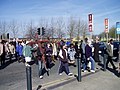
Good Friday walk crossing Princess Road
Our Lady's Church

Our Lady's Church interior


Sports[]
From 1923, Moss Side was the location of Manchester City F.C.'s stadium at Maine Road which on several occasions in its early years drew crowds of more than 80,000. However its capacity was gradually reduced over the years and by the mid-1990s it held just under 35,000 spectators all seated. Plans to rebuild the stadium to seat 45,000 were abandoned in favour of moving to the City of Manchester Stadium. Maine Road has since been demolished and a mixed development of two-, three-, and four-bedroom houses, flats, and a primary school has been built on the site.[22]
Notable people[]
The author Anthony Burgess, although born in Harpurhey, lived in Moss Side as a child,[75] as did the historian Michael Wood.[76] The clergyman and submarine inventor George Garrett was a Church of England vicar in Moss Side. The political activist and women's suffrage leader Emmeline Pankhurst was born in Moss Side.[77] Bertha Jane Grundy the novelist was born at Moss Side in 1837. The DJ "A Guy Called Gerald", real name Gerald Simpson, grew up in Moss Side. British rock musician and composer Barry Adamson was born in Moss Side. His debut solo album Moss Side Story is an imaginary soundtrack to a thriller set in Moss Side[78]
Notes[]
- ^ "City of Manchester Ward population 2011". Retrieved 5 January 2016.
- ^ "Moss Side and Rusholme District Centre Local Plan". Manchester City Council. 2007. p. 52.
- ^ Jump up to: a b c W.E.E.A. (11 November 1904). "Pepperhill Farm". Manchester Guardian.
- ^ "Moss Side". Greater Manchester County Record Office. Archived from the original on 11 February 2011. Cite journal requires
|journal=(help) - ^ "Maine Road Site History". Maine Road Art Programme. Retrieved 23 June 2013.
- ^ Jump up to: a b Ravenscroft, Nick (11 September 2006). "Killing surprises few in Moss Side". BBC News.
- ^ Jump up to: a b Randell, Tom (15 September 2006). "North West: Trying to banish 'Gunchester'". BBC News.
- ^ "A street guide to gangs in Manchester". BBC Manchester. 6 January 2003.
- ^ Osuh, Chris (7 April 2009). "Gooch Gang Smashed". Manchester Evening News.
- ^ "Funding boost for gun crime unit". BBC News. 4 June 2008.
- ^ Robson, Steve (2 March 2012). "Gangsters squeezed out of Moss Side and Hulme move into Wythenshawe to recruit drug dealers". Manchester Evening News.
- ^ "No-Go Britain: Where, what, why". 22 October 2011.
- ^ Jump up to: a b "Moss Side and Rusholme District Centre Local Plan". Manchester City Council. 2007. p. 35.
- ^ "Mahadi Hussein Sharif Mahamed". Manchester City Council. Retrieved 23 June 2013.
- ^ "Emily Rowles". Manchester City Council. Retrieved 23 June 2013.
- ^ "Sameem Ali". Manchester City Council. Retrieved 23 June 2013.
- ^ Celebrating 100 Years of Princess Road. Manchester: Stagecoach. April 2010.
- ^ "Bus firm Stagecoach travels to new stop as century-old depot shuts". Manchester Evening News. 19 August 2010.
- ^ "Map of Moss Side Ward". Manchester City Council. Archived from the original on 21 September 2013. Retrieved 23 June 2013.
- ^ Ali, S.; Cox, A.; Walters, R. (Autumn–Winter 2010). "New Houses for Moss Side". New Labour Rose.
- ^ Jump up to: a b Osuh, Chris (2 May 2007). "Transfer to Maine Road". Manchester Evening News.
- ^ Jump up to: a b Osuh, Chris (18 April 2010). "Bus site to become estate". Manchester Evening News.
- ^ "Moss Cider brews community spirit in Manchester". BBC News. 27 September 2010.
- ^ Jump up to: a b Final Proposals for the Regeneration of Bowes Street, Moss Side (PDF). Manchester City Council. 24 March 2010.
- ^ Jump up to: a b "Infusion of enthusiasm in Moss Side, Manchester". Easier Property. 15 December 2010.
- ^ Hunt, Michael (13 December 2010). "Moss Side housing project to be unveiled". Place North West.
- ^ "Buyers flock to Moss Side £17m regeneration scheme". Easier Property. 9 May 2011.
- ^ "Winners of the Housing Excellence Awards – 2011". Housing Excellence. Archived from the original on 13 March 2012.
- ^ "Housing Excellence Awards win for 'Infusion'". Easier Property. 20 May 2011.
- ^ "Consultation on Moss Side Bus Depot site tomorrow". Cranswick Square Residents Group. 14 March 2012.
- ^ Jump up to: a b Dyckhoff, Tom (7 September 2012). "Let's move to Moss Side". The Guardian.
- ^ Jump up to: a b c d Makepeace, Chris E (2011). Moss Side 1915: Lancashire Sheet 104.1. Old Ordnance Survey Maps. Consett: Alan Godfrey Maps. ISBN 978-1-84784-521-4.
- ^ "Pubs of Manchester: Walker & Homfrays, Salford". 10 July 2011.
- ^ Webster's Brewery
- ^ "Hydes Plans to Relocate Brewery" (PDF) (Press release). Hydes Brewery. 6 January 2012.
- ^ "Hydes in £2m move to Salford – 18 jobs to go". Manchester Evening News. 20 March 2012.
- ^ British Listed Buildings : Hydes Anvil Brewery, Manchester, retrieved 29 June 2013
- ^ Glendinning, Amy (9 November 2012). "Sale of Hydes Brewery in Moss Side scuppers £1m 'green' power station plan". Manchester Evening News.
- ^ http://themossciderproject.org/ The Moss Cider Project
- ^ "About Us". AquaTech Pressmain. Retrieved 23 June 2013.
- ^ Jump up to: a b c "Moss Side ward profile: Version 2010/1". Manchester City Council. Archived from the original on 22 September 2010. Retrieved 16 October 2010.
- ^ "Derived 2006-Based SNPP for 2011 StatWard – percentages". Manchester City Council. Archived from the original on 30 November 2010. Retrieved 16 October 2010.
- ^ "Derived 2006-Based SNPP for 2015 StatWard – percentages". Manchester City Council. Archived from the original on 1 December 2010. Retrieved 16 October 2010.
- ^ "Moss Side and Rusholme Local Plan – Manchester City Council". Manchester City Council. Retrieved 30 June 2013.
- ^ "Moss Side ward profile 2010/1". Manchester City Council. Archived from the original on 22 September 2010. Retrieved 16 October 2010.
- ^ "Moss Side and Rusholme Local Plan – Manchester City Council". Manchester City Council. 2007. p. 63. Retrieved 7 July 2013.
- ^ "Moss Side and Rusholme Local Plan – Manchester City Council". Manchester City Council. 2007. pp. 62, 126. Retrieved 7 July 2013.
- ^ Jump up to: a b "Moss Side and Rusholme Local Plan – Manchester City Council". Manchester City Council. 2007. pp. 120–121. Retrieved 7 July 2013.
- ^ African and Caribbean Mental Health Service http://www.acmhs.co.uk/
- ^ Knight, Leah (24 April 2013). "Manchester Caribbean Carnival 2013". The Manchester Gazette. Archived from the original on 7 July 2013.
- ^ "Somali Bravanese Sisters". CAN. Retrieved 7 July 2013.
- ^ "Polish School Manchester". Manchester City Council. Retrieved 7 July 2013.
- ^ Ed Glinert (24 April 2008). The Manchester Compendium: A Street-by-Street History of England's Greatest Industrial City. Penguin Books Limited. pp. 333–. ISBN 978-0-14-102930-6.
- ^ Moss Side Community Allotment, archived from the original on 23 July 2013, retrieved 29 June 2013
- ^ "Moss Side Residents build a garden and a community". Tony Lloyd MP. 3 June 2011. Archived from the original on 25 July 2011.
- ^ Bowes Street Residents Association, retrieved 29 June 2013
- ^ "Time is ripe for urban orchard on former Stagecoach depot site". Manchester City Council. 26 April 2013.
- ^ Hughes, Melanie (29 June 2013). "Ambassadors' Moss Side mission underway". Mancunian Matters.
- ^ "Polish Restaurants in Moss Side". Getpolishrestaurant. Archived from the original on 8 July 2013. Retrieved 7 July 2013.
- ^ "Indian Restaurants near Moss Side, Egremont". Yell. Retrieved 7 July 2013.
- ^ Qureshi, Yakub (28 April 2009). "Reborn school a class act". Manchester Evening News.
- ^ "Exam Results 2010". Manchester Academy. Archived from the original on 27 July 2011.
- ^ "Academy Partnership Award 2009". Education Business Awards. Archived from the original on 14 September 2010.
- ^ Angela, Epstein (6 December 2010). "Once-failing school now named as one of UK's best". Manchester Evening News.
- ^ "Teachers honoured in TES Schools Awards". tesconnect – Times Educational Supplement. 6 July 2014.
- ^ "Christ Church, Manchester". British Listed Buildings. Retrieved 23 June 2013.
- ^ Clergy: Fr Andrzej Zuziak SChr (Provincial and Parish Priest); Fr Artur Stelmach Schr; Fr Pawel Urbanek SChr
- ^ Cite error: The named reference
Almanacwas invoked but never defined (see the help page). - ^ Salford Diocesan Almanac; 2000, p. 55
- ^ Hartwell, Clare, et al. (2004). Lancashire: Manchester and the South-East. New Haven: Yale University Press. p. 481. ISBN 0-300-10583-5.
- ^ Pevsner, N. (1969). Lancashire: 1. Penguin Books. pp. 333–334.
- ^ Makespeace, C. (1995) Looking Back at Hulme, Moss Side, Chorlton on Medlock & Ardwick. Altrincham: Willow; p. 69
- ^ Church of the New Age; GenUKI; accessed 24 May 2019
- ^ Ratcliffe, Michael (2007). "Anthony Burgess". In: The Oxford Dictionary of National Biography. Oxford University Press.
- ^ People’s historian becomes Manchester Professor; University of Manchester
- ^ The birth indexes for the December Quarter of 1858 for the Chorlton registration district (vol. 8c, p. 529) record her name as Emiline Goulden, but she never seems to have used that spelling.
- ^ Marconie, S. NME, 11 March 1989 pp33
References[]
- Crofton, H. T. (1903). "Old Moss Side, Manchester". Cite journal requires
|journal=(help) - Porter, J. (1904). "In and Around Moss Side". Cite journal requires
|journal=(help) - South Manchester Regeneration Team (2007). "Moss Side and Rusholme District Centre Local Plan". Cite journal requires
|journal=(help)
External links[]
| Wikimedia Commons has media related to Moss Side. |
| Authority control |
|
|---|
- Areas of Manchester
- Manchester City Council Wards
- History of Manchester