Mott Haven, Bronx
Mott Haven | |
|---|---|
Neighborhood of the Bronx | |
 East 139th Street, between Willis and Brook Avenues, facing east | |
| Nickname(s): "The Boogie Down Bronx" | |
 Location in New York City | |
| Coordinates: 40°48′36″N 73°55′34″W / 40.81°N 73.926°WCoordinates: 40°48′36″N 73°55′34″W / 40.81°N 73.926°W | |
| Country | |
| State | |
| City | |
| Borough | |
| Community District | Bronx 1[1] |
| Founded | 1849 |
| Named for | Jordan Lawrence Mott |
| Area | |
| • Total | 3.06 km2 (1.180 sq mi) |
| Population (2010)[3] | |
| • Total | 52,413 |
| • Density | 17,000/km2 (44,000/sq mi) |
| Economics | |
| • Median income | $25,325 |
| Ethnicity | |
| • Hispanic | 72.3% |
| • Black | 24.7 |
| • White | 1.7 |
| • Asian | 0.4 |
| • Other | 1.0 |
| ZIP Codes | 10451, 10454, 10455 |
| Area codes | 718, 347, 929, and 917 |
| Website | www |
Mott Haven Historic District | |
U.S. National Register of Historic Places | |
U.S. Historic district | |
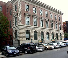 40th Precinct Police Station, July 2010 | |
| Location | An irregular pattern along Alexander Ave. and E. 138th St., New York, New York |
| Area | 11 acres (4.5 ha) |
| Built | 1850 |
| Architect | Multiple |
| Architectural style | Gothic, Queen Anne, Romanesque |
| NRHP reference No. | 80002586[5] |
| Added to NRHP | March 25, 1980 |

Mott Haven is a primarily residential neighborhood in the southwestern section of the New York City borough of the Bronx. Its boundaries, starting from the north and moving clockwise, are East 149th Street to the north, the Bruckner Expressway to the east, the Bronx Kill waterway to the south, and the Harlem River to the west. East 138th Street is the primary east–west thoroughfare through Mott Haven.
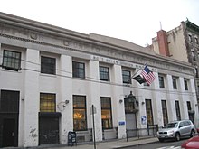
The neighborhood is part of Bronx Community Board 1, and is located within ZIP Codes 10451, 10454, and 10455.[6] Mott Haven is patrolled by the New York City Police Department's 40th Precinct.[7]
The local subway line is the IRT Pelham Line (6 and <6> trains), operating along East 138th Street. The local buses are the Bx1, Bx2, Bx15, Bx17, Bx19, Bx21, Bx32, Bx33. Mott Haven is served by the Triborough Bridge, the Third Avenue Bridge, the Madison Avenue Bridge, the 145th Street Bridge, and the Willis Avenue Bridge. The closest Metro-North Railroad stops are Harlem – 125th Street and Yankees – East 153rd Street.
History[]
Settlement by Jonas Bronck[]


The Bronx was named after the Swedish sea captain Jonas Bronck.[8] In 1639, the Dutch West India Company purchased the land of today's Mott Haven from the Wecquaesgeek (groups of Lenape tribe). Bronck built his farm on this land and named it "Emmanus". The house was located close to what is today the corner of Willis Avenue and 132nd Street. The peace treaty between Dutch authorities and the Wecquaesgeek chiefs Ranaqua and Tackamuckwas was signed in Bronck's house. This event is portrayed in a painting by the American artist John Ward Dunsmore (1856–1945).[9]
Even though Bronck only lived in the area for four years, the land became known as "Broncksland" and the river that bordered his land kept the name Bronck's River. The first time the spelling "Bronx land was used, was in 1697 in the First Legislature outlined the County of West Chester.[10]
Development[]
The area that is now called Mott Haven was sold to the Morris family in 1670.[10] A small part of the larger swath of land known as Morrisania, it was purchased by Jordan Lawrence Mott for his iron works in 1849. A vestige of the iron works can be seen just west of the Third Avenue Bridge on East 134th Street at St. Ann's Church (ECUSA) on St. Ann's Avenue is the resting place of Lewis Morris, Gouverneur Morris and other members of that powerful colonial family, and a Registered Historic Place.
As the city below grew, the area quickly developed residentially. At the same time, an upper-middle class residential area, marked by brownstones built in an elaborate and architecturally daring fashion, started to grow along Alexander Avenue by the 1890s (Doctors' Row, aka the Irish Fifth Avenue).[11] A series of brownstones on E. 134th St, east of Willis Ave., was known as Judges' Row. Soon after, the Bronx grew more quickly, especially with public transit into the area, including the Third Avenue Elevated Line. By the early 20th century, the population density of the area supported the construction of many tenement-style apartment buildings.
From the end of the 19th century through the 1940s, Mott Haven was a mixed German-American (north of E. 145th St.) and Irish-American neighborhood (south of E. 145th St), with an Italian enclave west of Lincoln Ave.[12] The first Puerto Rican settlements came in the late 1940s along the length of Brook Avenue.[13] African-Americans came into the area when Patterson Houses were built.[14]
One of the largest parades in New York City took place here in the late 1940s and early 1950s. It was organized by the veterans of the Irish Republican Army, who marched every Easter Sunday, down Willis Avenue from the Hub to E. 138th Street, then west to St. Jerome's. The Star of Munster Ballroom at the northeast corner of Willis Avenue and E. 138th Street was a center of Irish music for decades. It was speculated at one time that there were more bars on Willis Avenue than on any other city street, given its short length. More recorded Irish musicians lived in Mott Haven than in any place outside Ireland.[15]
"South Bronx" and late 20th century[]


Mott Haven and Port Morris were the first neighborhoods to give rise to the term "South Bronx". Together, they were earlier known as the North Side or North New York. This area was part of New York County after the incorporation of Greater New York in 1898.[16] The Chase Manhattan Bank at Third Avenue and E. 137th Street was originally the North Side Board of Trade Building (1912). It later became the North Side Savings Bank, which became Dollar Dry Dock, which became Chase.
In the 1940s when the Bronx was usually divided into the East Bronx and West Bronx, a group of social workers identified a pocket of poverty on East 134th Street, east of Brown Place, and called it the South Bronx. This area of poverty would spread in part due to an illegal practice known as blockbusting and to Robert Moses building several housing projects in the neighborhood. The poverty greatly expanded northward, following the post-war phenomenon colloquially referred to as white flight, reaching a peak in the 1960s when the socioeconomic North Bronx-South Bronx boundary reached Fordham Road. At this time a wave of arson destroyed or damaged many of the residential, commercial, and industrial structures in the area.[17]
Today the North Bronx-South Bronx distinction remains more common than the traditional East Bronx-West Bronx distinction, and some still regard Fordham Road as the boundary. Though crime has declined versus the highs of the crack epidemic and revitalization of former abandoned properties is taking place, the neighborhood continues to deal with serious crime issues, which some speculate is due to persistent poverty among the population.
During the course of Mott Haven's growth, the communities of Wilton and North New York were incorporated into it. Later attempts to market Mott Haven as the "Piano District" and the South Bronx as "SoBro" have not found traction.[18]
Development and gentrification[]
There have been significant strides to increase gentrification of the neighborhood, and the most changes are seen on Bruckner Boulevard, Alexander Avenue, and Lincoln Avenue.[19] E. 138th Street has seen minor changes with apartment buildings under new renovations, and the arrival of new businesses. Mott Haven is home to a community-supported agriculture program hosted at Brook Park.[20]
Recent development plans include two affordable rental buildings and a Hampton Inn by Monadnock Development and Signature Urban Properties,[21] and the so-called Piano District.
Demographics[]
Mott Haven is a high-density and mainly low-income neighborhood. Like most neighborhoods in New York City, the vast majority of households are renter-occupied. The neighborhood is largely Puerto Rican, with smaller numbers of African Americans, Mexicans and Dominicans present.[2]
Based on data from the 2010 United States Census, the population of Mott Haven and Port Morris was 52,413, a change of 3,383 (6.5%) from the 49,030 counted in 2000. Covering an area of 951.01 acres (384.86 ha), the neighborhood had a population density of 55.1 inhabitants per acre (35,300/sq mi; 13,600/km2).[3]
The racial makeup of the neighborhood was 1.7% (867) White, 24.7% (12,927) African American, 0.2% (95) Native American, 0.4% (214) Asian, 0% (7) Pacific Islander, 0.2% (124) from other races, and 0.6% (310) from two or more races. Hispanic or Latino of any race were 72.3% (37,869) of the population.[4]
The entirety of Community District 1, which comprises Mott Haven and Melrose, had 98,403 inhabitants as of NYC Health's 2018 Community Health Profile, with an average life expectancy of 77.6 years.[22]:2, 20 This is lower than the median life expectancy of 81.2 for all New York City neighborhoods.[23]:53 (PDF p. 84)[24] Most inhabitants are youth and middle-aged adults: 28% are between the ages of between 0–17, 28% between 25–44, and 21% between 45–64. The ratio of college-aged and elderly residents was lower, at 12% and 10% respectively.[22]:2
As of 2017, the median household income in Community Districts 1 and 2, including Longwood, was $20,966.[25] In 2018, an estimated 29% of Mott Haven and Melrose residents lived in poverty, compared to 25% in all of the Bronx and 20% in all of New York City. One in eight residents (12%) were unemployed, compared to 13% in the Bronx and 9% in New York City. Rent burden, or the percentage of residents who have difficulty paying their rent, is 58% in Mott Haven and Melrose, compared to the boroughwide and citywide rates of 58% and 51% respectively. Based on this calculation, as of 2018, Mott Haven and Melrose are considered to be low-income relative to the rest of the city and not gentrifying.[22]:7
Land use and terrain[]

Mott Haven is dominated by tenement-style apartment buildings and large public housing complexes. There are three historical districts consisting of brownstone-style rowhouses. In the last two decades, construction of modern 2- and 3-unit rowhouses and apartment buildings has increased the percentage of owner-occupiers. The neighborhood contains one of the highest concentrations of NYCHA projects in the Bronx. The total land area is roughly one square mile. The terrain is low-lying and flat except around St. Mary's Park where it is somewhat hilly.
Historical districts and landmarks[]
Three Historic Districts are located in Mott Haven: Mott Haven, Mott Haven East and the Bertine Block.
- The Mott Haven Historic District is located on Alexander Avenue between East 138th Street and East 141st Street.[26] The district is primarily residential in character with four and five-story row houses dating to the last half of the 19th century, and contains the row of handsome brownstones known historically as Doctors' Row and Irish Fifth Avenue. It also has the 40th Precinct police station, the 1905 neo-renaissance Mott Haven Branch of the New York Public Library, and Saint Jerome's Roman Catholic Church.[27][28] It was listed on the National Register of Historic Places in 1980.[5]
- The Mott Haven East Historic District is located on East 139th and East 140th Street between Brook and Willis Avenues. The district contains rows of handsome brownstones designed by William O'Gorman and William Hornum in 1883 combining Dutch and Flemish architectural aspects on the north side of E. 140th Street and neo-Grecian aspects on the south side of E. 140th Street and on E. 139th Street.[29]
- The Bertine Block Historic District is located on East 136th Street between Brook and Willis Avenues. The district contains yellow-faced brick brownstones designed by Edward Bertine between 1891 and 1895.[30][31]
St. Ann's Episcopal Church is located on the west side of St. Ann's Avenue between East 139th and East 141st Streets. It is the Bronx's oldest church, having been built in 1841 and dedicated to Gouverneur Morris's mother Ann. Notable figures buried there include Lewis Morris, a signer of the Declaration of Independence; Gouverneur Morris; and former mayor of New York, R. H. Morris.
Public housing projects[]

The seventeen NYCHA developments in Mott Haven illustrate the various types of public housing initiatives in vogue in New York City over the decades.[32]
- Dr. Ramon E. Betances I; thirteen buildings, 3, 4, 11 and 19 stories tall
- Dr. Ramon E. Betances II, 13; one 6-story building
- Dr. Ramon E. Betances II, 18; two buildings, 4 and 6 stories tall
- Dr. Ramon E. Betances II, 9A; one 4-story building.
- Dr. Ramon E. Betances III, 13; two rehabilitated tenement buildings, 5 stories tall.
- Dr. Ramon E. Betances III, 18; one rehabilitated and three abandoned tenement buildings 5 stories tall
- Dr. Ramon E. Betances III, 9A; two rehabilitated tenement buildings 6 stories tall
- Dr. Ramon E. Betances IV; eight buildings, 3, 4 and 5 stories tall with 282 apartments
- Dr. Ramon E. Betances V; six rehabilitated tenement buildings, 5 and 6 stories tall
- Dr. Ramon E. Betances VI; three rehabilitated tenement buildings, 5 and 6 stories tall
- Millbrook Houses; nine 16-story buildings
- Millbrook Extension; one 16-story building
- Mitchel Houses; ten buildings, 17, 19, and 20 stories tall
- Moore Houses; two 20-story buildings
- Mott Haven Houses; eight buildings, 20 and 22 stories tall
- Patterson Houses; fifteen buildings 6 and 13 stories tall
- Southern Boulevard M.H.O.P. (Multi Family Homeownership Program); one 7-story rehabilitated tenement building
Media[]
The Mott Haven Herald is a news outlet that reports in Mott Haven, Melrose and Port Morris. It is produced by students at the City University Graduate School of Journalism and edited by Joe Hirsch.
Police and crime[]
Mott Haven and Melrose are patrolled by the 40th Precinct of the NYPD, located at 257 Alexander Avenue.[7] The 40th Precinct ranked 59th safest out of 69 patrol areas for per-capita crime in 2010.[33] As of 2018, with a non-fatal assault rate of 186 per 100,000 people, Mott Haven and Melrose's rate of violent crimes per capita is greater than that of the city as a whole. The incarceration rate of 1,214 per 100,000 people is higher than that of the city as a whole.[22]:8
The 40th Precinct has a lower crime rate than in the 1990s, with crimes across all categories having decreased by 66.9% between 1990 and 2020. The precinct reported 13 murders, 30 rapes, 440 robberies, 722 felony assaults, 279 burglaries, 730 grand larcenies, and 177 grand larcenies auto in 2018.[34]
Fire safety[]
Mott Haven contains three New York City Fire Department (FDNY) fire stations:[35]
- Squad 41 – 330 East 150th Street[36]
- Engine Company 60/Ladder Company 17/Battalion 14 – 341 East 143rd Street[37]
- Engine Company 83/Ladder Company 29 – 618 East 138th Street[38]
In addition, FDNY EMS Station 14 is located at Lincoln Hospital at 234 East 149th Street.
Health[]
As of 2018, preterm births and births to teenage mothers are more common in Mott Haven and Melrose than in other places citywide. In Mott Haven and Melrose, there were 95 preterm births per 1,000 live births (compared to 87 per 1,000 citywide), and 35.1 births to teenage mothers per 1,000 live births (compared to 19.3 per 1,000 citywide).[22]:11 Mott Haven and Melrose has a relatively high population of residents who are uninsured. In 2018, this population of uninsured residents was estimated to be 14%, slightly higher than the citywide rate of 12%.[22]:14
The concentration of fine particulate matter, the deadliest type of air pollutant, in Mott Haven and Melrose is 0.0086 milligrams per cubic metre (8.6×10⁻⁹ oz/cu ft), more than the city average.[22]:9 Fifteen percent of Mott Haven and Melrose residents are smokers, which is higher than the city average of 14% of residents being smokers.[22]:13 In Mott Haven and Melrose, 42% of residents are obese, 20% are diabetic, and 38% have high blood pressure—compared to the citywide averages of 24%, 11%, and 28% respectively.[22]:16 In addition, 24% of children are obese, compared to the citywide average of 20%.[22]:12
Eighty-two percent of residents eat some fruits and vegetables every day, which is less than the city's average of 87%. In 2018, 72% of residents described their health as "good," "very good," or "excellent," lower than the city's average of 78%.[22]:13 For every supermarket in Mott Haven and Melrose, there are 25 bodegas.[22]:10
The nearest hospital is NYC Health + Hospitals/Lincoln.[39]
Post offices and ZIP Codes[]
Mott Haven is covered by multiple ZIP Codes. The section west of Third Avenue is part of 10451, while the sections east of Third Avenue are part of 10455 (north of 145th Street).[40] The section south of 145th Street is part of 10454. The United States Postal Service operates three post offices in Mott Haven:
- Bronx Station – 558 Grand Concourse[41]
- Mott Haven Station – 517 East 139th Street[42]
- Hub Station – 633 St. Ann's Avenue[43]
- Uptown Parcel Annex Station – 845 East 136th Street[44]
Education[]


Mott Haven and Melrose generally have a lower rate of college-educated residents than the rest of the city as of 2018. While 16% of residents age 25 and older have a college education or higher, 41% have less than a high school education and 43% are high school graduates or have some college education. By contrast, 26% of Bronx residents and 43% of city residents have a college education or higher.[22]:6 The percentage of Mott Haven and Melrose students excelling in math rose from 18% in 2000 to 37% in 2011, though reading achievement decreased slightly from 25% to 24% during the same time period.[45]
Mott Haven and Melrose's rate of elementary school student absenteeism is more than the rest of New York City. In Mott Haven and Melrose, 32% of elementary school students missed twenty or more days per school year, higher than the citywide average of 20%.[23]:24 (PDF p. 55)[22]:6 Additionally, 62% of high school students in Mott Haven and Melrose graduate on time, lower than the citywide average of 75%.[22]:6
Schools[]
Public:
- P.S. 18 John Peter Zenger School (East 148th St. and Morris Ave.)
- P.S. 277 Dr. Evelina Lopez Antonetty (East 147th St. and St. Ann's Ave.)
- P.S 25 Bilingual School (811 E 149th St)
- P.S. 30 Wilton School (East 141st St. and Brook Ave.)
- P.S. 40 Mott Haven Village (East 140th St. and Brook Ave.)
- P.S. 43 Jonas Bronck School (East 136th St. and Brown Place)
- P.S. 49 Willis Avenue School (East 139th St. and Willis Ave.)
- P.S. 65 Mother Hale Academy (East 141st St. and Cypress Ave.)
- I.S. 139 A. Burger Intermediate School (East 143rd St. and Brook Ave.)
- I.S. 162 Lola Rodriguez de Tio (E 149th St. and St. Ann's Ave.)
- M.S. 223: The Laboratory School of Finance and Technology (East 145th St. and Willis Ave.)
- P.S. 154 Johnathan D. Hyatt School (East 135th St. and Alexander Ave.)
- I.S. 183 Paul Robeson School (East 140th St. and Morris Ave.)
- P.S. 754 School For Career Development/Foreign Language Academy Of Global Studies (East 147th St and Jackson Ave.)
- P.S. 221 South Bronx Preparatory: A College Board School (East 144th St. and Willis Ave.)
- South Bronx Charter School for International Cultures and the Arts
- The Bronx Charter School for Children
- The Bronx Academy of Letters
- Bronx School For Law Government And Justice
- Health Opportunities High School
- Community School For Social Justice
- Family Life Academy Charter School II
- New York City Montessori Charter School
- Mott Haven Academy Charter School
- Samuel Gompers High School (closed)
- KIPP Academy Elementary School
- KIPP Academy Middle School
- Success Academy Bronx 1
- Eugenio María de Hostos Community College of The City University of New York (CUNY)
- Hostos Lincoln Academy (located within the Hostos Community College campus.)
Parochial:
- Saint Luke School
- Saint Pius V School
- Saint Pius V High School
- St. Anselm's School
Library[]
The New York Public Library operates the Mott Haven branch at 321 East 140th Street. The branch, a Carnegie library, opened in 1905 and is a New York City designated landmark.[46]
Transportation[]


The following New York City Subway stations serve Mott Haven:[47]
- 138th Street–Grand Concourse (4 and 5 trains)
- Third Avenue–138th Street (6 and <6> trains)
- Brook Avenue (6 train)
- Cypress Avenue (6 train)
- East 143rd Street–St. Mary's Street (6 train)
- 149th Street–Grand Concourse (2, 4, and 5 trains)
- Third Avenue–149th Street (2 and 5 trains)
The following MTA Regional Bus Operations bus routes serve Mott Haven:[48]
- Bx1: to Riverdale (via Grand Concourse)
- Bx2: to Kingsbridge Heights (via Grand Concourse)
- Bx4/Bx4A: to Westchester Square (via Westchester Avenue)
- Bx15: to Fordham Plaza or Manhattanville (via Third Avenue)
- Bx17: to Fordham Plaza (via Prospect and Crotona Avenues)
- Bx19: to Riverbank State Park or Bronx Park (via 149th Street and Southern Boulevard)
- Bx21: to Westchester Square – East Tremont Avenue (6 and <6> trains) (via Boston Road and Morris Park Avenue)
- Bx32: to VA Hospital (via Morris Avenue and Jerome Avenue)
- Bx33: to Harlem or Port Morris, Bronx (via 138th Street)
- Bx41 (Including Select Bus Service): to Williamsbridge (via Melrose Avenue and Webster Avenue)
The 145th Street Bridge and Madison Avenue Bridge eastward and the Willis Avenue Bridge northward from Manhattan lead to Mott Haven and are maintained by NYCDOT. The Triborough Bridge, which also ends in Mott Haven, is maintained by the MTA Bridges and Tunnels, and is tolled.
Notable residents[]
People who were born, raised, or live in Mott Haven.
- A.G., rapper of the duo Showbiz and A.G. was raised in the Patterson Houses.[49]
- Danny Aiello (1933–2019), actor who lived on Bergen Ave. and attended Monroe H.S.[citation needed]
- Nate Archibald (born 1948), former NBA player, was raised in the Patterson Houses.[citation needed]
- Iran Barkley (born 1960), former boxer was raised in the Patterson Houses.[50]
- Jonas Bronck (d. 1643), sea captain who was the borough's first European settler and after whom the Bronx is named.[51]
- Bobby Darin (1936–1973), singer who lived at 629 E. 135 St. and attended P.S. 43.[citation needed]
- ESG, band, are from the Moore Houses.
- Pedro Espada Jr. (born 1953), former member of the New York Senate, who was convicted on federal corruption charges in May 2012 and sentenced to five years in prison.[52]
- Guy Fisher (born 1947), former drug lord is from the Patterson Houses.
- Edward J. Flynn (1891–1953), politician who served as chairman of the Democratic National Committee from 1940 to 1943.[53]
- Kase2 (1958–2011), graffiti artist, is from the Moore Houses.
- Jonathan Luna (1965–2003) lawyer who served as Assistant United States Attorney in Baltimore.[54]
- French Montana (born 1984), rapper, is from the Mott Haven Houses.
- Percee P (born 1969), rapper, was raised in the Patterson Houses.
- Johnny Pacheco (1935-2021), musician, arranger, composer, producer and bandleader of Cuban music, who coined the term "Salsa" to denote the genre.[55]
- Luis Antonio Ramos (born 1973), actor, is from the Patterson Houses.
- Prince Royce (born 1989), singer, is from the Patterson Houses.
- José E. Serrano (born 1943), Congressman representing the Bronx, was raised in the Millbrook Houses.
- Rod Strickland (born 1966), NBA player, was raised in the Mitchel Houses.[citation needed]
References[]
- ^ "NYC Planning | Community Profiles". communityprofiles.planning.nyc.gov. New York City Department of City Planning. Retrieved 25 February 2018.
- ^ Jump up to: a b "Mott Haven neighborhood in New York". Retrieved June 4, 2014.
- ^ Jump up to: a b Table PL-P5 NTA: Total Population and Persons Per Acre - New York City Neighborhood Tabulation Areas*, 2010, Population Division - New York City Department of City Planning, February 2012. Accessed June 16, 2016.
- ^ Jump up to: a b Table PL-P3A NTA: Total Population by Mutually Exclusive Race and Hispanic Origin - New York City Neighborhood Tabulation Areas*, 2010, Population Division - New York City Department of City Planning, March 29, 2011. Accessed June 14, 2016.
- ^ Jump up to: a b "National Register Information System". National Register of Historic Places. National Park Service. March 13, 2009.
- ^ "Bronx Community District 1" (PDF). Archived from the original (PDF) on 4 March 2016. Retrieved 21 September 2015.
- ^ Jump up to: a b "NYPD – 40th Precinct". www.nyc.gov. New York City Police Department. Retrieved October 3, 2016.
- ^ "The Story of The Bronx". The Bronx County Historical Society. 2016-02-03. Retrieved 2016-07-12.
- ^ "East River NYC :: History". www.eastrivernyc.org. Retrieved 2016-07-12.
- ^ Jump up to: a b "THE BRONX MALL Cultural Mosaic - The Bronx... Its History & Perspective". www.bronxmall.com. Retrieved 2016-07-12.
- ^ "Mott Haven Historic District - History" (PDF). Archived from the original (PDF) on 2 March 2010. Retrieved 21 September 2015.
- ^ "Bronx Irish Americans: American Irish History in the Bronx". Retrieved 22 September 2015.
- ^ "A South Bronx Latin Music Tale" (PDF). Archived from the original (PDF) on 2015-09-24. Retrieved 2015-09-22.
- ^ "Painting a Portrait of Black Experience in the Bronx". The New York Times. Retrieved 22 September 2015.
- ^ "Anne and Timothy Kelly mark golden anniversary". The Riverdale Press. Retrieved 28 September 2015.
- ^ "Bronx Chronology". Archived from the original on 27 July 2015. Retrieved 28 September 2015.
- ^ "The Bronx County Historical Society". Archived from the original on 9 June 2015. Retrieved 21 September 2015.
- ^ Hughes, C. J. (March 6, 2020) "The Neighborhood Name Game" The New York Times
- ^ Hughes, C.J. "Mott Haven, the Bronx, in Transition". The New York Times. Retrieved 24 October 2015.
- ^ "Friends of Brook Park". Retrieved 22 September 2015.
- ^ Wirsing, Robert (January 15, 2016). "Project slated for Mott Haven". Bronx Times Reporter. p. 1.
- ^ Jump up to: a b c d e f g h i j k l m n o "Mott Haven and Melrose (Including Melrose, Mott Haven and Port Morris)" (PDF). nyc.gov. NYC Health. 2018. Retrieved March 2, 2019.
- ^ Jump up to: a b "2016-2018 Community Health Assessment and Community Health Improvement Plan: Take Care New York 2020" (PDF). nyc.gov. New York City Department of Health and Mental Hygiene. 2016. Retrieved September 8, 2017.
- ^ "New Yorkers are living longer, happier and healthier lives". New York Post. June 4, 2017. Retrieved March 1, 2019.
- ^ "NYC-Bronx Community District 1 & 2--Hunts Point, Longwood & Melrose PUMA, NY". Census Reporter. Retrieved July 17, 2018.
- ^ "Archived copy" (PDF). Archived from the original (PDF) on 2009-05-30. Retrieved 2008-03-04.CS1 maint: archived copy as title (link)
- ^ "Mott Haven Landmarked District" (PDF). Archived from the original (PDF) on 2009-05-30. Retrieved 2008-03-04.
- ^ Elizabeth Spencer-Ralph and Suzanne J. Wilson (June 1979). "National Register of Historic Places Registration: Mott Haven Historic District". New York State Office of Parks, Recreation and Historic Preservation. Retrieved 2011-01-12. See also: "Accompanying 24 photos".
- ^ "Mott Haven East Landmarked District" (PDF). Archived from the original (PDF) on 2009-05-30. Retrieved 2008-03-04.
- ^ "Bertine Block Landmarked District" (PDF). Archived from the original (PDF) on 2009-05-30. Retrieved 2008-03-04.
- ^ "To Have and Have Mott". Forgotten New York. Retrieved 2010-01-16.
- ^ "NYCHA Redirect". Archived from the original on 25 May 2015. Retrieved 29 April 2016.
- ^ "Mott Haven – DNAinfo.com Crime and Safety Report". www.dnainfo.com. Archived from the original on April 15, 2017. Retrieved October 6, 2016.
- ^ "40th Precinct CompStat Report" (PDF). www.nyc.gov. New York City Police Department. Retrieved July 22, 2018.
- ^ "FDNY Firehouse Listing – Location of Firehouses and companies". NYC Open Data; Socrata. New York City Fire Department. September 10, 2018. Retrieved March 14, 2019.
- ^ "Squad Company 41". FDNYtrucks.com. Retrieved March 14, 2019.
- ^ "Engine Company 60/Ladder Company 17/Battalion 14". FDNYtrucks.com. Retrieved March 14, 2019.
- ^ "Engine Company 83/Ladder Company 29". FDNYtrucks.com. Retrieved March 14, 2019.
- ^ "Best 30 Hospitals in Bronx, NY with Reviews". Yellow Pages. Retrieved March 14, 2019.
- ^ "Mott Haven, New York City-Bronx, New York Zip Code Boundary Map (NY)". United States Zip Code Boundary Map (USA). Retrieved March 14, 2019.
- ^ "Location Details: Bronx". USPS.com. Retrieved March 7, 2019.
- ^ "Location Details: Mott Haven". USPS.com. Retrieved March 7, 2019.
- ^ "Location Details: Hub". USPS.com. Retrieved March 7, 2019.
- ^ "Location Details: Uptown Parcel Annex". USPS.com. Retrieved March 7, 2019.
- ^ "Mott Haven and Melrose – BX 01" (PDF). Furman Center for Real Estate and Urban Policy. 2011. Retrieved October 5, 2016.
- ^ "About the Mott Haven Library". The New York Public Library. Retrieved March 14, 2019.
- ^ "Subway Map" (PDF). Metropolitan Transportation Authority. July 2021. Retrieved January 18, 2018.
- ^ "Bronx Bus Map" (PDF). Metropolitan Transportation Authority. October 2018. Retrieved December 1, 2020.
- ^ "AG: Andre's New Posse". Retrieved 21 September 2015.
- ^ Stoffers, Carl. "No More Bouts, but the Fight Goes On; Former Boxer Tries to Help Others Get Back on Their Feet", Wall Street Journal, December 26, 2014. Accessed October 15, 2018. "These days, around the Mott Haven neighborhood where he grew up, Mr. Barkley is often stopped for handshakes and fist bumps."
- ^ Plitt, Amy. "A Brief History of the Bronx: From First Settlers to Modern Megaprojects; From its earliest settlements to the megaprojects of the present day", Curbed, April 11, 2016. Accessed October 15, 2018. "1639 - Jonas Bronck becomes the Bronx's first European settler Scandinavian immigrant: Bronck came to New York (then New Netherland) in 1639, settling in what's now Mott Haven."
- ^ "Eye on Albany Campaign 2002: State Senate District 32", Gotham Gazette. Accessed October 15, 2018. "Senator Pedro Espada, Jr. (Dem/Rep) was born in Puerto Rico and raised in Mott Haven."
- ^ Hughes, C.J. "Bonfire of the Vanities No Longer", The New York Times, July 23, 2006. Accessed October 15, 2018. "Edward J. Flynn, one of many Irish-Americans who grew up in Mott Haven in the early 20th century, was a career politician who became head of the Bronx County Democratic Party, a power in choosing candidates for higher office."
- ^ Dao, James; and Lichtblau, Eric. "Torture Is Possible in Prosecutor's Death", The New York Times, December 6, 2003. Accessed October 15, 2018. "Born in the Mott Haven section of the Bronx, Mr. Luna attended Fordham University, graduating with a bachelor's degree in communications in 1988."
- ^ 1960's - 1980's, Brons Music Heritage Center. accessed October 15, 2018. "The leaders in this genre were the Fania record label, which was founded by a former lawyer and cop from Brooklyn, Jerry Masucchi, and a Dominican musician who grew up in Mott Haven, Johnny Pacheco."
External links[]
| Wikimedia Commons has media related to Mott Haven, Bronx. |
- The Mott Haven Herald - produced by the CUNY Graduate School of Journalism
- Mott Haven in Forgotten NY
- Historical and demographic information on Mott Haven from Community Board 1
- Mott Haven Historic District Map (Living Places.com)

| show U.S. National Register of Historic Places in New York |
|---|

- Mott Haven, Bronx
- Neighborhoods in the Bronx