Port Morris, Bronx
Port Morris | |
|---|---|
Neighborhood of the Bronx | |
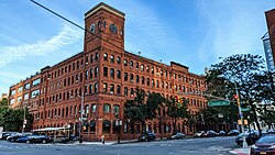 The Clock Tower, former factory now serving residential and commercial tenants | |
 Location in New York City | |
| Coordinates: 40°48′07″N 73°54′36″W / 40.802°N 73.91°WCoordinates: 40°48′07″N 73°54′36″W / 40.802°N 73.91°W | |
| Country | |
| State | |
| City | New York City |
| Borough | The Bronx |
| Community District | Bronx 1[1] |
| Area | |
| • Total | 1.92 km2 (0.742 sq mi) |
| Population (2011)[2] | |
| • Total | 3,523 |
| • Density | 1,800/km2 (4,700/sq mi) |
| Economics | |
| • Median income | $38,834 |
| Ethnicity[3] | |
| • Hispanic and Latino Americans | 72.3% |
| • African-American | 24.7% |
| • White | 1.7% |
| • Asian | 0.4% |
| • Others | 1% |
| ZIP Codes | 10454, 10451 |
| Area code | 718, 347, 929, and 917 |
| Website | www |

Port Morris is a mixed use, primarily industrial neighborhood geographically located in the southwest Bronx, New York City.[4] The neighborhood is part of Bronx Community Board 1.[5] Its boundaries are the Major Deegan Expressway and Bruckner Expressway to the north, East 149th Street to the east, the East River to the southeast, the Bronx Kill to the south, and the Harlem River (Park Avenue stub) to the west. Its ZIP Code is 10454 and 10451. The neighborhood is served by the NYPD's 40th Precinct.[6]
Oak Point, the southern tip of the South Bronx, is in Port Morris; it contains the Oak Point Yard. The area is also traversed by the Bruckner Expressway, a major freeway. Most of the neighborhood is within walking distance from several stations of IRT Pelham Line (6 train).
Demographics[]

Port Morris predominantly consists of Latin Americans (primarily Puerto Rican), African Americans as well as a small white population concentrated mainly in the western portion of Bruckner Boulevard. Almost half of the population lives below the federal poverty line and receives public assistance (TANF, Home Relief, Supplemental Security Income, and Medicaid). Nonetheless, the median income is significantly higher than that of other South Bronx neighborhoods. This is likely due to recent rezoning[4] to increase commercial and residential activity in the area.[2][7]
Based on data from the 2010 United States Census, the population of Mott Haven and Port Morris was 52,413, a change of 3,383 (6.5%) from the 49,030 counted in 2000. Covering an area of 951.01 acres (384.86 ha), the neighborhood had a population density of 55.1 inhabitants per acre (35,300/sq mi; 13,600/km2).[8]
The racial makeup of the neighborhood was 1.7% (867) White, 24.7% (12,927) African American, 0.2% (95) Native American, 0.4% (214) Asian, 0% (7) Pacific Islander, 0.2% (124) from other races, and 0.6% (310) from two or more races. Hispanic or Latino of any race were 72.3% (37,869) of the population.[9]
History[]
The history of Port Morris, as with other neighborhoods, is sometimes confused by the lack of fixed official boundaries. Late in the 20th century the name was sometimes applied to the area to the west, into Mott Haven. Mott Haven by older definition lies to the west rather than north of Port Morris.
Settlement[]

There is some evidence that a British paymaster ship went down off Port Morris's coast during the American Revolutionary War with millions of dollars in gold aboard. The cargo has never been recovered.[10][11]
The name comes from a deep water port established along the neighborhood's East River (Long Island Sound) waterfront by Gouverneur Morris Jr., son of Gouverneur Morris, in 1842. He built a two-mile (3 km) railroad from Melrose to his family's holdings on the waterfront, later called the Spuyten Duyvil and Port Morris Railroad, abandoned a hundred years later.[12]
Development[]
The area is dominated by factory and warehouse buildings constructed in the mid-to-late 19th century, convenient to the railroad yards, of which the Oak Point Yard is the main survivor. Notable early businesses were the R. Hoe Co.; Cutler & Hammer Tool Works; Mothers Friend Shirt Waist factory (1888) at Willow Avenue between East 135th and 136th Streets;[13] and the (now designated a city landmark by the New York City Landmarks Preservation Commission).[14] While many of the early industrial buildings remain, they are little used for manufacturing anymore.
In the 1870s the Mott Haven Canal emptied out into the Western Port Morris riverfront serving industry in the Mott Haven area. After being declared a "nuance" by the Board of Health in 1896 the canal was slowly re-filled, its last segment being in use until 1960s. Today only a small indentation in the Harlem River remains
The area was the site of the Hell Gate generating plant of Consolidated Edison, where George Metesky, the Mad Bomber who plagued New York City for decades was injured.[15]
The most notable architectural/engineering feature of Port Morris is the northern approach to the Hell Gate Bridge supported by concrete arches (1917) northward from East 132nd Street, between Willow & Walnut Avenues. Plans are afoot to extend the South Bronx Greenway to Randalls Island, crossing Bronx Kill via the Randall's Island Connector under Hell Gate Bridge. The Connector opened in November 2015.[16][17][18]
A wave of arson during the 1970s destroyed or damaged many residential, commercial, and industrial structures in the area. Late in the century industry began to return to Port Morris. Many abandoned residential buildings are also being rehabilitated and designated low income housing.[19]
Re-zoning[]

In 1997 the New York City council created the "Port Morris Special Mixed-used District", the site of the first special mixed-use district (MX-1)[20]resulting in the rehabilitation of several blocks of residential row-houses between Bruckner Boulevard and East 134th Street in an area which only previously allowed industrial uses.[21] Following the success of the 1997 re-zoning, the city further expanded this district in 2005 to include all of western Port Morris (south of Major Deegan Expressway and west of RFK Bridge).[21] In December 2017 the city council approved the expansion of the "Special Harlem River Waterfront District" to cover two super blocks in western Port Morris. This latest rezoning allowed high-density mixed-used development along the banks of the Harlem River from Lincoln Avenue north through Mott Haven up to 150th Street in Concourse Village.[22][23]
Redevelopment and gentrification[]

The neighborhood has been experiencing massive revitalization with many historic warehouses, factories and various manufacturing buildings being converted into lofts. The former Estey Piano Corp factory, now The Clock Tower, has the restaurant Charlies Bar & Kitchen operating on the ground level.[24] Port Morris has become a burgeoning community of artists and other young professionals looking for more reasonable options outside of Manhattan.[25] Efforts by the New York Restoration Project are underway to revive the waterfront in an area that historically suffers from high asthma rates. This will create much-needed green space for the community.[26][27] As a result of these changes, the neighborhood is slowly becoming a hub for upscale eateries in the South Bronx.[28] Additionally, in 2015, Silvercup Studios announced it would convert a 115,000-square-foot warehouse at 295 Locust Avenue for film and television productions.[29] Silvercup North, as the facility was known, opened in mid-2016.[30][31]

The Piano District is the name proposed by two developers for Port Morris. The two developers, Somerset Partners and The Chetrit Group, purchased two riverfront properties for $58 million with the goals of establishing luxury residences and retail.[32] However, there is opposition to the renaming, and critics and proponents have accused one another of racism.[33] The developers were criticized by Melissa Mark-Viverito, the president of the New York City Council for conducting a Halloween rave, attended by numerous celebrities and featuring flaming trash cans and hulks of burnt-out and bullet-riddled cars. Mark-Viverito accused the developers of a lack of empathy and basic awareness.[34]
Additional developments continued to take place at Port Morris. In June 2016, the Bluestone Group purchased a 235,584-square-foot (21,886.5 m2) former factory building at 825 East 141st Street for $44 million;[35] That building was renovated in 2019 and became Union Crossing, a mixed-use development with offices, retail spaces, and studios.[36][37] In 2020, renting commenced for The Arches at 224-228 East 135th Street, the first market-rate high-rise rental development in Port Morris.[38] Another rental development at 101 Bruckner Boulevard, with 55 units, was announced in early 2021.[39] In addition, Brookfield Properties is currently developing "Bankside", a complex of seven high-rise residential towers on the banks of the Harlem River with over 1,350 units. The first phase at 2401 Third Avenue was topped out during 2021. Bankside will include a public esplanade along the Harlem River[40][41] A high-rise residential development has been announced at 2455 Third Avenue.[42]
Land use[]

Port Morris contains a variety of zoning districts ranging from manufacturing, commercial, residential, and mixed-use. The eastern half of Port Morris contains primarily light industrial, warehousing and distribution uses guided by the Port Morris Industrial Business Zone.[43] The Bruckner Boulevard corridor is primarily a mixed-use corridor transitioning from previous industrial uses to commercial and residential usage spurred by the Port Morris Special Mixed-Use District re-zoning laws.[44] The western end of Port Morris is rapidly transitioning from light-industrial uses to high-density residential developments along the newly created "Special Harlem River Waterfront District". The area centered in Alexander Avenue-Bruckner Blvd is now the main commercial corridor in the neighborhood with a growing crop of restaurants and other services.
Landmarked buildings[]
City landmarks[]
Two structures in Port Morris have been land-marked by the city's Landmarks Preservation Commission. The Estey Piano Company Factory, now referred to as the "Clock Tower", is located at the corner of Lincoln and Bruckner Boulevard. While the Clock Tower is now a commercial and residential building it is reminiscent of the time period in which Port Morris was a hub for piano manufacturing in the city. At least one piano manufacturer remains in the neighborhood.
The Bronx Grit Chamber is a 1937 Neo-classical structure located at East 132nd Street and St. Ann's Avenue, built as part of the larger sewage treatment complex in Wards Island. The Bronx Grit Chamber processes raw sewage by removing large particles on its way to further treatment at the Wards Island Water Pollution Control Plant. It is currently managed by the New York City Department of Environmental Protection.[45]
National Register of Historic Places listings[]
Education[]
- South Bronx Charter School for International Cultures and the Arts (East 133rd Street and Cypress Pl)
- Per Scholas operates its main branch at 804 E 138th Street.[46]
Media[]
The Mott Haven Herald is a news outlet that reports in Mott Haven, Melrose and Port Morris. It is produced by students at the City University Graduate School of Journalism and edited by Joe Hirsch. The New York Post operates a printing plant in the neighborhood.
Transportation[]
The following New York City Subway stations serve Port Morris:[47]
- 138th Street–Grand Concourse (4 and 5 trains)
- Third Avenue–138th Street (6 and <6> trains)
- Brook Avenue (6 train)
- Cypress Avenue (6 train)
The following MTA Regional Bus Operations bus routes serve Port Morris:[48]
- Bx15: to Fordham Plaza or Manhattanville via Third Avenue
- Bx17: to Fordham Plaza via Crotona and Prospect Avenues
- Bx33: to 135th Street station (served by the 2 and 3 trains) via 138th Street
Bruckner Boulevard, which runs under the Bruckner Expressway (Interstate 278), is the primary thoroughfare through Port Morris.
As part of a conceptualization by think tank ReThink Studio that was not recognized by the city or state, a train station in Port Morris will be the northern terminal for a trunk line that would be a regional hub for transportation to other places in the states of New York and Connecticut. The station's site and context could accommodate connections to Manhattan and LaGuardia Airport via the trunk line, Northeast Corridor, and local bus routes. The station, a planned adjacent convention center, and supporting development is proposed to encourage other growth in the South Bronx.[49]
References[]
- ^ "NYC Planning | Community Profiles". communityprofiles.planning.nyc.gov. New York City Department of City Planning. Retrieved February 25, 2018.
- ^ a b c "Port Morris neighborhood in New York". Retrieved August 12, 2015.
- ^ "Center for Urban Research". Archived from the original on October 13, 2015. Retrieved September 18, 2015.
- ^ a b "Port Morris Rezoning". Retrieved August 12, 2015.
- ^ "Bronx Community District 1" (PDF). Archived from the original (PDF) on March 4, 2016. Retrieved September 18, 2015.
- ^ 40th Precinct, NYPD.
- ^ Hughes, C. J. (March 25, 2015). "Mott Haven, the Bronx, in Transition". The New York Times. Retrieved August 12, 2015.
- ^ Table PL-P5 NTA: Total Population and Persons Per Acre - New York City Neighborhood Tabulation Areas*, 2010, Population Division - New York City Department of City Planning, February 2012. Accessed June 16, 2016.
- ^ Table PL-P3A NTA: Total Population by Mutually Exclusive Race and Hispanic Origin - New York City Neighborhood Tabulation Areas*, 2010, Population Division - New York City Department of City Planning, March 29, 2011. Accessed June 14, 2016.
- ^ "Port Morris in Forgotten NY". Retrieved September 8, 2015.
- ^ Vanderbilt, Tom (February 17, 2002). "Ship of Dreams". The New York Times. Retrieved September 8, 2015.
- ^ Port Morris Branch, the so-called Bronx Swamp December 23, 2009, The LTV Squad
- ^ "Historic Districts Council — Port Morris History" (PDF). p. 2. Retrieved October 22, 2015.
- ^ "Estey Piano Company Factory" (PDF). New York City Landmarks Preservation Commission. May 16, 2006. Retrieved December 26, 2019.
- ^ "Printers Row Preview 'Curiosity's Cats' editor recounts Mad Bomber research". Chicago Tribune. Retrieved November 17, 2015.
- ^ Small, Eddie. "Bronxites Can Get Free Rides to the Randall's Island Connector This Spring". DNAinfo. Archived from the original on November 18, 2015. Retrieved November 17, 2015.
- ^ South Bronx Greenway
- ^ Miller, Stephen. "Eyes on the Street: Randall's Island Connector to Open in "Coming Weeks"". Retrieved October 22, 2015.
- ^ "Port Morris & The 134th Street Ferry Bridges, The Bronx". Retrieved October 31, 2015.
- ^ https://www1.nyc.gov/assets/planning/download/pdf/plans-studies/sustainable-communities/bmn/bronx_metro_report/land_use_zoning.pdf
- ^ a b https://www1.nyc.gov/assets/planning/download/pdf/plans/port-morris/portmorrisstudyarea.pdf
- ^ https://www1.nyc.gov/assets/planning/download/pdf/plans-studies/bronx-harlem-river/presentation-060517.pdf?r=1
- ^ "Bronx Harlem River - DCP".
- ^ Boryga, Andrew (August 19, 2015). "Charlies Bar & Kitchen Is a Pioneering Dining Option in a Poor Bronx Neighborhood". The New York Times. Retrieved September 18, 2015.
- ^ Kaysen, Ronda (September 17, 2015). "The South Bronx Beckons". The New York Times. Retrieved September 18, 2015.
- ^ "The Haven Project". Retrieved September 18, 2015.
- ^ Ramey, Corinne (September 21, 2015). "Green Space and Health Linked in Vision for South Bronx". The Wall Street Journal. Retrieved September 21, 2015.
- ^ Wall, Patrick. "New Upscale Bars and Eateries Make Their Way to Port Morris". DNAinfo. Archived from the original on April 25, 2015. Retrieved October 31, 2015.
- ^ Hu, Winnie (July 7, 2015). "Silvercup Studios Is Turning a Bronx Warehouse Into Its 3rd Production Complex". The New York Times. Retrieved August 12, 2015.
- ^ Walker, Ameena (August 17, 2016). "Silvercup Studios opens the South Bronx's first film and TV studio". Curbed NY. Retrieved October 6, 2021.
- ^ Hughes, C. J. (September 23, 2016). "Industrial Retro in Long Island City". The New York Times. ISSN 0362-4331. Retrieved October 6, 2021.
- ^ Small, Eddie. "South Bronx is Now the 'Piano District,' Billboard Proclaims". DNAInfo:NY. Archived from the original on December 2, 2015.
- ^ Ramos, Andrew (November 16, 2015). "Community outraged after developers attempt to rename South Bronx 'The Piano District'".
- ^ Yakas, Ben. "Real Estate Developers' "Bronx Is Burning" Rave Criticized For Tone-Deafness". Archived from the original on April 2, 2016. Retrieved April 2, 2016.
- ^ Clarke, Katherine (June 16, 2016). "Bluestone, Altmark nab Bronx factory building for $44M". The Real Deal New York. Retrieved October 6, 2021.
- ^ Young, Michael (January 13, 2019). "Union Crossing at 825 East 141st Street Nearing Opening Day Amidst Residential Boom in South Bronx". New York YIMBY. Retrieved October 6, 2021.
- ^ Baird-Remba, Rebecca (November 4, 2019). "Union Crossing in the South Bronx Signs Affordable Housing Org Westhab". Commercial Observer. Retrieved October 6, 2021.
- ^ "Now Renting: The South Bronx's First Luxury High Rise Gentrification Towers". Welcome2TheBronx. July 1, 2020. Retrieved October 6, 2021.
- ^ Morris, Sebastian (March 1, 2021). "Renderings Revealed for 101 Bruckner Boulevard in Port Morris, The Bronx". New York YIMBY. Retrieved October 6, 2021.
- ^ "Brookfield tops out latest tower in Bankside development". Real Estate Weekly. March 26, 2021. Retrieved October 6, 2021.
- ^ Gannon, Devin (November 20, 2019). "$950M South Bronx development Bankside set to open first residential tower this year". 6sqft. Retrieved October 6, 2021.
- ^ "Permits Filed for 2455 Third Avenue in Mott Haven, The Bronx". New York YIMBY. January 1, 2020. Retrieved October 13, 2021.
- ^ https://www.nycctp.com/wp-content/uploads/2019/07/nycctp-website-ibz-map-bronx-port-morris.pdf
- ^ https://www1.nyc.gov/assets/planning/download/pdf/plans/port-morris/portmorrisstudyarea.pdf
- ^ https://www.lehman.edu/vpadvance/artgallery/arch/buildings/BGrit.html
- ^ "Per Scholas Official Website". Retrieved November 24, 2015.
- ^ "Subway Map" (PDF). Metropolitan Transportation Authority. September 2021. Retrieved September 17, 2021.
- ^ "Bronx Bus Map" (PDF). Metropolitan Transportation Authority. October 2018. Retrieved December 1, 2020.
- ^ Sayer, Jason. "Jim Venturi and ReThinkNYC want to revolutionize how NYC handles train infrastructure", The Architect's Newspaper, May 26, 2016. Accessed August 1, 2016.
External links[]
| Wikimedia Commons has media related to Port Morris, Bronx. |
| South Bronx |  | |
|---|---|---|
| West Bronx | ||
| East Bronx | ||
| Related areas |
| |
- Port Morris, Bronx
- Populated coastal places in New York (state)
- Neighborhoods in the Bronx