Mount Lincoln (Colorado)
| Mount Lincoln | |
|---|---|
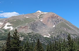 View of Mt Lincoln from Colorado State Highway 9 | |
| Highest point | |
| Elevation | 14,293 ft (4356.5 m)[1] NAVD88 |
| Prominence | 3862 ft (1177 m)[2] |
| Isolation | 22.5 mi (36.2 km)[2] |
| Listing |
|
| Coordinates | 39°21′05″N 106°06′42″W / 39.3514512°N 106.1115668°WCoordinates: 39°21′05″N 106°06′42″W / 39.3514512°N 106.1115668°W[1] |
| Naming | |
| Etymology | Abraham Lincoln |
| Geography | |
 Mount Lincoln Colorado | |
| Location | High point of Park County, Colorado, United States[2] |
| Parent range | Highest summit of the Mosquito Range[2] |
| Topo map | USGS 7.5' topographic map Alma, Colorado[3] |
| Climbing | |
| Easiest route | hike |

Mount Lincoln is the eighth-highest summit of the Rocky Mountains of North America and the U.S. state of Colorado. The prominent 14,293-foot (4356.5 m) fourteener is the highest summit of the Mosquito Range and the eleventh-highest summit in the contiguous United States. Mount Lincoln is located in Pike National Forest, 5.2 miles (8.3 km) north-northwest (bearing 332°) of the Town of Alma in Park County, Colorado, United States. The summit of Mount Lincoln is the highest point in Park County and the entire drainage basin of the Missouri River. The mountain was named in honor of Abraham Lincoln, 16th President of the United States.[1][2][3]
Climbing[]
Mount Lincoln is typically climbed from the Kite Lake Trailhead, at the end of Park County Road 8. Many climbers attempt to combine the summit of Lincoln with those of Bross and Democrat in one climb.[4]
Access issues[]
Silver was discovered here in 1874.[5]:56
Mount Lincoln, along with its neighbors Cameron, Democrat and Bross, are pockmarked with old mines, and much of the land is owned privately by mining companies. (A large mine still operates in nearby Climax.) In the summer of 2005, these landowners denied access to the peaks by hikers and climbers, fearing liability in the case of injury, and citing the particular dangers due to the presence of old mine workings. On August 1, 2006, the town of Alma signed a deal to lease the peaks for a nominal fee, to reduce the potential liability to the owners and free up the peaks for recreational access.[6] The opening of these peaks excludes the summit of Mount Bross since not all of the landowners have given permission for access to the area.[7]
In May, 2021, access to Mount Democrat and Mount Lincoln was closed due to liability and overcrowding concerns. The closure was temporary, with access having reopened on June 1, 2021. [8][9]

See also[]
- List of mountain peaks of North America
- List of mountain peaks of the United States
- List of mountain peaks of Colorado
- List of Colorado county high points
- List of Colorado fourteeners
- List of mountain peaks of Colorado
- List of mountain peaks of the United States
References[]
- ^ Jump up to: a b c "MT LINCOLN". NGS data sheet. U.S. National Geodetic Survey. Retrieved January 2, 2016.
- ^ Jump up to: a b c d e "Mount Lincoln, Colorado". Peakbagger.com. Retrieved January 2, 2016.
- ^ Jump up to: a b "Mount Lincoln". Geographic Names Information System. United States Geological Survey. Retrieved November 14, 2014.
- ^ Louis W. Dawson II (1994). Dawson's Guide to Colorado's Fourteeners, Volume 1. Blue Clover Press. ISBN 0-9628867-1-8.
- ^ Voynick, S.M., 1992, Colorado Gold, Missoula: Mountain Press Publishing Company, ISBN 0878424555
- ^ "Alma officials mount trail-access campaign". Denver Post. August 8, 2006.
- ^ http://www.14ers.org/peaks/mosquito-range/mount-democrat/
- ^ https://www.alexmderr.com/mount-bross-is-closed/
- ^ https://coloradosun.com/2021/04/30/colorado-fourteeners-14ers-closure-lincoln-democrat-bross/
External links[]
| Wikimedia Commons has media related to Mount Lincoln. |
| show |
|---|
| show |
|---|
| show |
|---|
| show |
|---|

| Authority control |
|
|---|
- Mountains of Colorado
- Mountains of Park County, Colorado
- Pike National Forest
- Fourteeners of Colorado
- North American 4000 m summits