Mount McGillivray
| Mount McGillivray | |
|---|---|
 Mount McGillivray | |
| Highest point | |
| Elevation | 2,451 m (8,041 ft)[1] |
| Prominence | 211 m (692 ft)[1] |
| Parent peak | Skogan Peak (2662 m)[2] |
| Listing | Mountains of Alberta |
| Coordinates | 51°01′13″N 115°09′52″W / 51.02028°N 115.16444°WCoordinates: 51°01′13″N 115°09′52″W / 51.02028°N 115.16444°W[3] |
| Geography | |
 Mount McGillivray Location of Mount McGillivray in Alberta | |
| Location | Alberta, Canada |
| Parent range | Canadian Rockies |
| Topo map | NTS 82O3 Canmore[3] |
| Geology | |
| Age of rock | Cambrian |
| Type of rock | Limestone |
| Climbing | |
| Easiest route | Scramble |

Mount McGillivray is a 2,451-metre (8,041-foot) mountain summit located in the Bow Valley of Kananaskis Country in the Canadian Rockies of Alberta, Canada. Its nearest higher peak is Skogan Peak, 3.0 km (1.9 mi) to the southeast.[2] Mount McGillivray is a landmark that can be seen from Highway 1, the Trans-Canada Highway in the Exshaw area.
History[]
Mount McGillivray was named for Duncan McGillivray (1770-1808), one of the first white men along with David Thompson to see the Bow Valley.[2] In November 1800, McGillivray and Thompson rode south on a trip from the newly established fort at Rocky Mountain House and explored west into the Bow Valley as far as what is now Mount McGillivray in search of the headwaters of the Columbia River.[4] The mountain's name was officially adopted in 1957 by the Geographical Names Board of Canada.[3]
During the Cold War, tunnels and vaults were constructed under the north slope of the mountain as part of a plan to safely store government documents, however the project was never completed.[5]
Geology[]
Mount McGillivray is composed of sedimentary rock laid down during the Precambrian to Jurassic periods.[6] Formed in shallow seas, this sedimentary rock was pushed east and over the top of younger rock during the Laramide orogeny.[7]
Climate[]
Based on the Köppen climate classification, Mount McGillivray is located in a subarctic climate with cold, snowy winters, and mild summers.[8] Temperatures can drop below −20 °C with wind chill factors below −30 °C. Precipitation runoff from Mount McGillivray drains into the Bow River which is a tributary of the Saskatchewan River.
Gallery[]
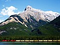
Mount McGillivray seen across Gap Lake
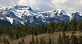
Mount McGillivray and Pigeon Mountain

Mount McGillivray from Reed Lake
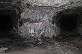
tunnels and vaults under the north slope of the mountain


See also[]
References[]
- ^ a b "Mount McGillivray, Canada". Peakbagger.com. Retrieved 2019-09-16.
- ^ a b c "Mount McGillivray". Bivouac.com. Retrieved 2018-11-08.
- ^ a b c "Mount McGillivray". Geographical Names Data Base. Natural Resources Canada. Retrieved 2018-11-08.
- ^ "Mount McGillivray". PeakFinder.com. Retrieved 2019-09-16.
- ^ "A Dark Secret: Inside Alberta's Nuclear Bunker". Highline Magazine. August 22, 2015 [Story first appeared in Winter 2009 issue]. Retrieved 2019-09-16.
- ^ Belyea, Helen R. (1960). The Story of the Mountains in Banff National Park (PDF). parkscanadahistory.com (Report). Ottawa: Geological Survey of Canada. Archived (PDF) from the original on 2015-10-02. Retrieved 2019-09-13.
- ^ Gadd, Ben (2008). Geology of the Rocky Mountains and Columbias.
- ^ Peel, M. C.; Finlayson, B. L.; McMahon, T. A. (2007). "Updated world map of the Köppen−Geiger climate classification". Hydrol. Earth Syst. Sci. 11: 1633–1644. ISSN 1027-5606.
External links[]
- Mount McGillivray weather web site: Mountain Forecast
Places adjacent to Mount McGillivray | ||||||||||||||||
|---|---|---|---|---|---|---|---|---|---|---|---|---|---|---|---|---|
| ||||||||||||||||
- Two-thousanders of Alberta
- Canadian Rockies
- Alberta's Rockies