Mount Quincy Adams (Fairweather Range)
| Mount Quincy Adams | |
|---|---|
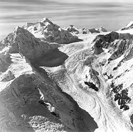 Mount Quincy Adams in upper left, with Mount Tlingit below/left of it. Aerial view by Austin Post. 1972 | |
| Highest point | |
| Elevation | 4,150 m (13,620 ft)[1] |
| Prominence | 410 m (1,350 ft)[1] |
| Listing |
|
| Coordinates | 58°54′32″N 137°27′05″W / 58.90889°N 137.45139°WCoordinates: 58°54′32″N 137°27′05″W / 58.90889°N 137.45139°W[2] |
| Geography | |
 Mount Quincy Adams Alaska Panhandle / Stikine Region, British Columbia | |
| Parent range | Fairweather Range |
| Topo map | USGS Mount Fairweather D-5 Canada NTS 114I14 |
| Climbing | |
| First ascent | Bradford Washburn, H. Adams Carter, 1934[3] |


Mount Quincy Adams (alternate Name Boundary Peak 163) is a mountain located on the border between United States and Canada. It is named after John Quincy Adams (1767–1848), the sixth president of the United States.
The southern and eastern flanks of the mountain are in Glacier Bay National Park, in Hoonah-Angoon Census Area, Alaska. The northern and northwestern flanks are in Tatshenshini-Alsek Park, in Stikine Region, British Columbia, making it the second highest peak in B.C. Mount Quincy Adams is flanked to the west by Mount Fairweather 4,671 m (15,325 ft).
References[]
- ^ a b "Mount Quincy Adams". Peakbagger.com. Retrieved 2006-10-10.
- ^ "Mount Quincy Adams". Geographic Names Information System. United States Geological Survey. Retrieved 2006-10-10.
- ^ "Mount Quincy Adams". Bivouac.com. Retrieved 2006-10-10.
External links[]
| |
| Presidency |
|
| Other events | |
| Writings |
|
| Life and homes | |
| Electoral history | |
| Legacy | |
| Popular culture | |
| Adams family Quincy family |
|
| Related | |
| |
This article about a location in the Hoonah-Angoon Census Area, Alaska is a stub. You can help Wikipedia by . |
This article about a location in British Columbia, Canada is a stub. You can help Wikipedia by . |
- Mountains of Alaska
- Four-thousanders of British Columbia
- Saint Elias Mountains
- Mountains of Glacier Bay National Park and Preserve
- Landforms of Hoonah–Angoon Census Area, Alaska
- Canada–United States border
- International mountains of North America
- Mountains of Unorganized Borough, Alaska
- Hoonah–Angoon Census Area, Alaska geography stubs
- British Columbia geography stubs