Mount Tsubakuro
| Mount Tsubakuro | |
|---|---|
| 燕岳 | |
 Mount Tsubakuro (June 2015) | |
| Highest point | |
| Elevation | 2,762.85 m (9,064.5 ft)[1] |
| Listing | List of mountains in Japan |
| Coordinates | 36°24′25″N 137°42′46″E / 36.40694°N 137.71278°ECoordinates: 36°24′25″N 137°42′46″E / 36.40694°N 137.71278°E[2] |
| Naming | |
| Language of name | Japanese |
| Pronunciation | [tsɯbakɯɾodake] |
| Geography | |
 | |
| Parent range | Hida Mountains |
| Topo map | Geospatial Information Authority 25000:1 槍ヶ岳[2] 50000:1 槍ヶ岳 |
| Climbing | |
| Easiest route | Hike |

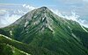
Mount Tsubakuro (燕岳, Tsubakuro-dake) is a 2,763-metre-high (9,065 ft) mountain in Azumino, Nagano Prefecture, Japan. It is situated in Japan's Hida Mountains in Nagano Prefecture. It was specified for[clarification needed] Chūbu-Sangaku National Park on December 4, 1934.[3] Granite forms the unique body with white sands and sharp rocks exposed at the top. Kassen One (ridge) is a steep trail challenging to climbers ascending from Nakabusa Hot Springs.
Mountain hut[]
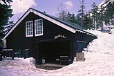
The mountain climbing trail between Mount Tsubakuro and Mount Yari is called Main Street (表銀座, Omote-Ginza) owing to its extensive use over time. It has two mountain huts along the way. Tsubakuro mountain cottage (燕山荘, Enzansō) is near the summit and is one of the oldest mountain huts in Japan, completed in 1921.[4]

|
|

|
| Enzanso (Tsubakuro mt. cottage) |
Kassen-goya (Kassen hut) |
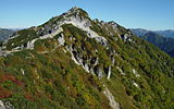
Trail as seen from Mt. Ohensho |
|---|
Geography[]
Nearby mountains[]
The following are the main mountains in the surrounding area:
| Image | Mountain | Elevation | Distance from the Top |
Note |
|---|---|---|---|---|

|
餓鬼岳 |
2,647.19 m (8,685 ft) | 5.0 km (3.1 mi) | 200 Famous Japanese Mountains |

|
Mt. Tsubakuro 燕岳 |
2,839.58 m (9,316 ft) | 0 km (0.0 mi) | 200 Famous Japanese Mountains |

|
大天井岳 |
2,921.91 m (9,586 ft) | 4.7 km (2.9 mi) | 200 Famous Japanese Mountains |
|
Mt. Jōnen 常念岳 |
2,857 m (9,373 ft) | 9.1 km (5.7 mi) | 100 Famous Japanese Mountains |

|
Mt. Yari 槍ヶ岳 |
3,180 m (10,433 ft) | 9.3 km (5.8 mi) | 100 Famous Japanese Mountains |
Rivers[]
The rivers flowing on the slopes of Mount Tsubakuro are mountain streams flowing towards the Shinano River basin. The Nakabusa River[5] rises on the eastern side and tributaries of the upper stream of the Takase River rise on the western slopes.[6]
Gallery[]
View from Mount Tsubakuro[]

Scenery of Mount Tsubakuro[]

|

|

|
|
| Top | in Spring | Mt. Tubakuro & Hut | in Autumn |
|---|
References[]
- ^ "Information inspection service of the Triangulation station" (in Japanese). Geospatial Information Authority of Japan,(高山-槍ヶ岳-槍ヶ岳). Archived from the original on June 9, 2009. Retrieved December 30, 2010.
- ^ Jump up to: a b "Map inspection service" (in Japanese). Geospatial Information Authority of Japan,(高山-槍ヶ岳-槍ヶ岳). Retrieved December 30, 2010.
- ^ "Chūbu-Sangaku National Park". Ministry of the Environment (Japan). Archived from the original on February 27, 2012. Retrieved December 30, 2010.
- ^ "Home Page" (in Japanese). Enzanso Group. Retrieved 8 April 2016.
- ^ Nakabusa River (中房川, Nakabusa-gawa).
- ^ Asahi Shimbun (August 2018). "燕岳". Kotobank (in Japanese). Retrieved 6 August 2018.
See also[]
| Wikimedia Commons has media related to Mount Tsubakuro. |
This Nagano Prefecture location article is a stub. You can help Wikipedia by . |
- Hida Mountains
- Mountains of Nagano Prefecture
- Nagano geography stubs