Mulkhra
| Mulkhra Mulkhura | |
|---|---|
 | |
 | |
| Native name | მულხრა (Georgian) |
| Location | |
| Country | Georgia |
| Region | Caucasus |
| Physical characteristics | |
| Source | Lesser Caucasus |
| • location | Georgia |
| Mouth | Enguri |
• coordinates | 43°00′16″N 42°37′41″E / 43.00437°N 42.62803°ECoordinates: 43°00′16″N 42°37′41″E / 43.00437°N 42.62803°E |
| Length | 27 km (17 mi) |
| Basin features | |
| Progression | Enguri→ Black Sea |


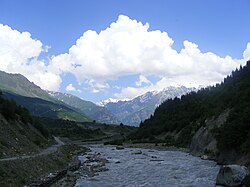
The Mulkhra or Mulkhura (Georgian: მულხრა, მულხურა) is a river in Mestia Municipality, Georgia, right tributary of the Enguri. [1] It is located in the region Samegrelo-Zemo Svaneti, in the northwestern part of the country, 230 km (140 mi) northwest of the capital Tbilisi. Length 27 km (17 mi), basin area 435 km2 (168 sq mi). It originates on the southern slope of the Svaneti Caucasus main ridge, on the Tviberi Glacier and joins the Enguri River near the village . Mulkhura feeds on glaciers, snow, rain and groundwater.[2] Floods are known from April to October, and water shortages - from October to April, from late November to late March - on the ice and in Toshi. The average annual flow at the confluence is 22.5 m3/s (790 cu ft/s). [1]
References[]
| Wikimedia Commons has media related to Mulkhra. |
- ^ a b Mulkhura at Geonames.org entry updated 2012-01-17
- ^ Levan Tielidze, Roman Kumlaze, Lasha Asanidze Glaciers Reduction and Climate Change Impact over the Last One Century in the Mulkhura River Basin, Caucasus Mountains, Georgia International Journal of Geosciences, 2015, 6, 465-472
Categories:
- Tributaries of the Enguri
- Asia river stubs
- Europe river stubs
- Georgia (country) geography stubs
- Rivers of Georgia (country)
- Geography of Samegrelo-Zemo Svaneti