Municipality of Prebold
Municipality of Prebold
Občina Prebold | |
|---|---|
 | |
 Coat of arms | |
 Location of the Municipality of Prebold in Slovenia | |
| Coordinates: 46°14′13″N 15°05′31″E / 46.23694°N 15.09194°ECoordinates: 46°14′13″N 15°05′31″E / 46.23694°N 15.09194°E | |
| Country | |
| Government | |
| • Mayor | Vinko Debelak |
| Area | |
| • Total | 41 km2 (16 sq mi) |
| Population (July 1, 2018)[1] | |
| • Total | 5,052 |
| • Density | 120/km2 (320/sq mi) |
| Time zone | UTC+01 (CET) |
| • Summer (DST) | UTC+02 (CEST) |
| Website | www |

The Municipality of Prebold (pronounced [ˈpɾeːbɔlt]; Slovene: Občina Prebold) is a small municipality in central Slovenia. The seat of the municipality is Prebold. The municipality lies on the edge of the lower Savinja Valley at the northern edge of the Sava Hills west of Celje. The area is part of the traditional region of Styria. The municipality is now included in the Savinja Statistical Region.[2] It is primarily known for growing hops.[3]
Settlements[]
In addition to the municipal seat of Prebold, the municipality also includes the following settlements:
- Dolenja Vas
- Kaplja Vas
- Latkova Vas
- Marija Reka
- Matke
- Šešče pri Preboldu
- Sveti Lovrenc

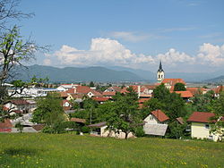
Villages of municipality
References[]
- ^ Jump up to: a b "Občina Prebold". Statistični urad Republike Slovenije. Retrieved April 9, 2020.
- ^ Prebold municipal site
- ^ "Municipality of Prebold". Slovene Municipalities in Numbers. Statistical Office of the Republic of Slovenia. Retrieved 13 October 2012.
External links[]
 Media related to Municipality of Prebold at Wikimedia Commons
- Municipality Prebold at Geopedia
- Municipality of Prebold website
| show Places adjacent to Municipality of Prebold |
|---|

| Authority control |
|
|---|
This article about the Municipality of Prebold in Slovenia is a stub. You can help Wikipedia by . |
Categories:
- Municipality of Prebold
- Municipalities of Slovenia
- 1998 establishments in Slovenia
- Savinjska statistical region geography stubs