Municipality of Idrija
Municipality of Idrija
Občina Idrija | |
|---|---|
 | |
 Coat of arms | |
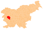
 Location of the Municipality of Idrija in Slovenia | |
| Coordinates: 46°00′N 14°01′E / 46.000°N 14.017°ECoordinates: 46°00′N 14°01′E / 46.000°N 14.017°E | |
| Country | |
| Government | |
| • Mayor | Tomaž Vencelj |
| Area | |
| • Total | 293.7 km2 (113.4 sq mi) |
| Population (2002)[1] | |
| • Total | 11,990 |
| • Density | 41/km2 (110/sq mi) |
| Time zone | UTC+01 (CET) |
| • Summer (DST) | UTC+02 (CEST) |
| Website | www |
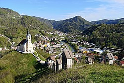
The Municipality of Idrija (pronounced [ˈiːdrija]; Slovene: Občina Idrija) is a municipality in the Gorizia region of western Slovenia. The seat of the municipality is the town of Idrija. The municipality is located in the traditional region of the Slovenian Littoral and is in the Gorizia Statistical Region.
Settlements[]
In addition to the municipal seat of Idrija, the municipality also includes the following settlements:
- Čekovnik
- Črni Vrh
- Dole
- Godovič
- Gore
- Gorenja Kanomlja
- Gorenji Vrsnik
- Govejk
- Idrijska Bela
- Idrijske Krnice
- Idrijski Log
- Idršek
- Javornik
- Jelični Vrh
- Kanji Dol
- Korita
- Ledine
- Ledinske Krnice
- Ledinsko Razpotje
- Lome
- Masore
- Mrzli Log
- Mrzli Vrh
- Pečnik
- Potok
- Predgriže
- Razpotje
- Rejcov Grič
- Spodnja Idrija
- Spodnja Kanomlja
- Spodnji Vrsnik
- Srednja Kanomlja
- Strmec
- Vojsko
- Zadlog
- Zavratec
- Žirovnica
History[]
For the history of the town of Idrija itself, see Idrija.
Near the town of Idrija there was an archaeological find of an approximately 43,100-year-old juvenile cave bear femur at Divje Babe, which may be a prehistoric flute.
Under Italian rule (1918–1943, nominally lasted to 1947), the area that is now the Municipality of Idrija was a comune of the Province of Gorizia (as Idria), except during the period between 1924 and 1927, when the Province of Gorizia was abolished and annexed to the Province of Udine.
References[]
External links[]
 Media related to Municipality of Idrija at Wikimedia Commons
- Idrija, official page of the municipality (in Slovene)
- Municipality of Idrija on Geopedia
- Municipality of Idrija
- Municipalities of Slovenia


