Vojsko, Idrija
Vojsko | |
|---|---|
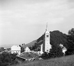 Vojsko (1959) | |
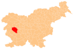
 Vojsko Location in Slovenia | |
| Coordinates: 46°1′25.09″N 13°54′12.25″E / 46.0236361°N 13.9034028°ECoordinates: 46°1′25.09″N 13°54′12.25″E / 46.0236361°N 13.9034028°E | |
| Country | |
| Traditional region | Inner Carniola |
| Statistical region | Gorizia |
| Municipality | Idrija |
| Area | |
| • Total | 41.22 km2 (15.92 sq mi) |
| Elevation | 1,083.3 m (3,554.1 ft) |
| Population (2002) | |
| • Total | 197 |
| [1] | |

Vojsko (pronounced [ˈʋoːi̯skɔ] or [ˈʋɔːi̯skɔ], German: Woiska[2]) is a dispersed settlement in the hills west of Idrija in the traditional Inner Carniola region of Slovenia.[2] It has a cluster of buildings centered on the parish church at its centre, and includes a number of smaller hamlets as well as remote farmsteads in the surrounding hills.[3]
The parish church is dedicated to Saint Joseph and belongs to the Koper Diocese.[4]
References[]
- ^ Statistical Office of the Republic of Slovenia
- ^ Jump up to: a b Leksikon občin kraljestev in dežel zastopanih v državnem zboru, vol. 6: Kranjsko. Vienna: C. Kr. Dvorna in Državna Tiskarna. 1906. p. 126.
- ^ Idrija municipal site
- ^ "Koper Diocese list of churches" (PDF). Archived from the original (PDF) on 2009-03-06. Retrieved 2009-03-06.
External links[]
| show Authority control |
|---|
Categories:
- Populated places in the Municipality of Idrija
- Goriška statistical region geography stubs