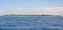
Muraidhoo (Haa Alif Atoll)
Muraidhoo
މުރައިދޫ | |
|---|---|
island | |
 | |
 Muraidhoo Location in Maldives | |
| Coordinates: 6°50′23″N 73°09′54″E / 6.83972°N 73.16500°ECoordinates: 6°50′23″N 73°09′54″E / 6.83972°N 73.16500°E | |
| Country | Maldives |
| Geographic atoll | Thiladhunmathi Atoll |
| Administrative atoll | Haa Alif Atoll |
| Distance to Malé | 297.1 km (184.6 mi) |
| Government | |
| • Council | Muraidhoo Island Council |
| Dimensions | |
| • Length | 1.05 km (0.65 mi) |
| • Width | 0.68 km (0.42 mi) |
| Population (2014)[1] | |
| • Total | 467 (including foreigners) |
| Time zone | UTC+05:00 (MST) |
| Area code(s) | 650, 20 |
Muraidhoo (Dhivehi: މުރައިދޫ) is one of the inhabited islands of Haa Alif Atoll administrative division and is geographically part of Thiladhummathi Atoll in the north of the Maldives. It is an island-level administrative constituency governed by the Muraidhoo Island Council. It is one of the intra-atoll islands (i.e. not forming the atoll border).
History[]
There are no archaeological remains of interest on the island. Notable figures from Muraidhoo include Hassan Kaleyge who served as the Treasurer of the Kings for many sultans of the Isdhoo and Dhiyamigili Dynastries and Hussein Dahara Takurufan who was the foreign minister during Sultan Ghazi Hassan Izudeen's reign 1759–1767.
Geography[]
The island is 297.1 km (185 mi; 160 nmi) north of the country's capital, Malé.[2]
Demography[]
| Year | Pop. | ±% |
|---|---|---|
| 2006 | 451 | — |
| 2014 | 444 | −1.6% |
| 2006-2014: Census populations Source: [3] | ||
References[]
- ^ "Table PP5: Resident Population by sex, nationality and locality (administrative islands), 2014" (PDF). Population and Households Census 2014. National Bureau of Statistics. p. 33. Retrieved 9 August 2018.
- ^ "Coordinate Distance Calculator". Boulter.com. Retrieved 9 August 2018.
- ^ "Table 3.3: Total Maldivian Population by Islands" (PDF). National Bureau of Statistics. Retrieved 9 August 2018.
External links[]
- Islands of the Maldives
- Maldives geography stubs
