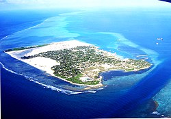
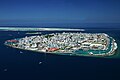
Thinadhoo (Gaafu Dhaalu Atoll)
Thinadhoo | |
|---|---|
Inhabited island | |
 | |
 Thinadhoo Location in Maldives | |
| Coordinates: 0°31′48.83″N 72°59′47.44″E / 0.5302306°N 72.9965111°ECoordinates: 0°31′48.83″N 72°59′47.44″E / 0.5302306°N 72.9965111°E | |
| Country | Maldives |
| Administrative atoll | Gaafu Dhaalu Atoll |
| Distance to Malé | 407.06 km (252.94 mi) |
| Government | |
| • Council | Thinadhoo Council |
| Area | |
| • Total | 1.192 km2 (0.460 sq mi) |
| Dimensions | |
| • Length | 1.560 km (0.969 mi) |
| • Width | 0.922 km (0.573 mi) |
| Population (2014)[1] | |
| • Total | 5,230 (including foreigners) |
| Time zone | UTC+05:00 (MST) |

Thenadu or Thinadhoo is the capital of Gaafu Dhaalu Atoll and the proposed capital for the Upper South Province of the Maldives. It has its own dialect of Dhivehi which is considerably different from northern and mid-Maldivian speech.
It is pronounced as Thenadu in the Southern Maldives dialect.
The island was formerly known as Havaru Thinadhoo and it was the traditional seat of the Atoll Chief.
History[]
Early history[]
Written history of the island is sparse, but Thinadhoo is known to have a rich history.
Havaru Thinadhoo[]

Suvadive was already a flourishing fishing industry with its own sustained economy when the Havaru ( locally meaning millitary ) was established.
Bodu Thakurufaanu sent the military factions known as 'Havaru' from Malé. They were organized as two ranks of three divisions each: the Is Thinvaru (the lead three powers) - Dhoshimeynaa Varu, Velaanaa Varu and Hakuraa Varu; and the Fas Thinvaru (the rear three powers) - Maafaiy Varu, Dhaharaa Varu and Faamuladheyri Varu.
Muhammad Thakurufaanu Al Auzam offered hakaru the island of Thinadhoo, He ordered that the 'dhandu kolhu', 'medhu ruganddu' and 'Baraaseel' to be given to Havaru along with the islands of , Kaadedhdhoo and . The island itself was renamed Havaru Thinadhoo signifying the occupation.
When 'havaru' were given these six regions they leased them to the people of Thinadhoo under the system. Each year Thinadhoo people were to send the annual to the 'Havaru' based in Male'. This practice lasted till the sultanate of Muhammad Mueenuddeen I who was the sultan of the Maldives from 1798 to 1835.[4]
United Suvadive Republic[]
Havaru Thinadhoo was the economic hub of the United Suvadive Republic which formed a breakaway nation from Maldives.
Depopulation of Havaru Thinadhoo[]
On the 4th February 1962 the Kingdom of Maldives reacted by sending a fully armed gunboat to Havaru Thinadhoo commanded by Prime Minister Ibrahim Nasir.
Enamaa boat incident[]
The Maldive boat Enamaa was carrying far more than its capacity of up to 126 when a wave overturned it. Twenty one people died with two missing when Enamaa capsized into the sea of Gaafu Dhaalu atoll on 17 March 2004.[5]
The Enamaa boat was traveling at nine and a half nautical miles per hour to Thinadhoo Island after watching the home team play a football match in Vilingili Island in Gaafu Alifu atoll.
Geography[]
The island is 407.06 km (253 mi; 220 nmi) south of the country's capital, Malé.[6]
Demography[]
| Year | Pop. | ±% |
|---|---|---|
| 2006 | 4,442 | — |
| 2014 | 4,669 | +5.1% |
| 2019 | 6,376 | +36.6% |
| 2006-2019: Census populations Source: [7] | ||
Education[]
Thinadhoo is served by 4 pre-schools, 2 primary schools, 1 secondary/high-school and 3 university/college campuses.[8]
- Maldives National University Thinadhoo Campus
- Thinadhoo School
- Aboobakuru School
- MI Preschool and Daycare
- Uloomiyya Pre School
- Kangaroo kids M.M. International Preschool
- Ameer Ibrahim Pre School
- Avid College
- Center for the Holy Quran
Transport[]
Kaadedhdhoo Domestic Airport is situated on a nearby island connected by speed boat.
See also[]
- United Suvadive Republic
- Upper South Province
- Huvadhu Atoll
References[]
- ^ "Table PP5: Resident Population by sex, nationality and locality (administrative islands), 2014" (PDF). Population and Households Census 2014. National Bureau of Statistics. p. 36. Retrieved 14 August 2018.
- ^ Jump up to: a b FRIAS, Xavier ROMERO. RULES FOR MALDI VIAN TRADING SHIPS TRA VELLING ABROAD (1925) AND A SOJOURN IN SOUTHERN CEYLON. http://www.jstor.org/stable/24920196: jstor. p. 3.CS1 maint: location (link)
- ^ Bernard, Koechlin. "In: Archipel, 1979. Commerces et navires dans les mers du Sud". Notes sur l'histoire et le navire long-courrier, odi, aujourd'hui disparu, des Maldives. volume 18: 293.
|volume=has extra text (help) - ^ N. T. Hassan Didi (2005). "Kureege Huvadhoo Atholhu". Novelty Press.
- ^ Who is to take responsibility for the horrific Enamaa boat disaster? Accessed June 4, 2008. Archived 10 February 2008 at the Wayback Machine
- ^ "Coordinate Distance Calculator". Boulter.com. Retrieved 14 August 2018.
- ^ "Table 3.3: Total Maldivian Population by Islands" (PDF). National Bureau of Statistics. Retrieved 14 August 2018.
- ^ "Ministry of Education Stat Book 2015" (PDF). Ministry of Education. Ministry of Education. Retrieved 24 April 2016.
External links[]
| show Island-level constituencies of the Maldives |
|---|
| Rank | Name | Division | Pop. | ||||||
|---|---|---|---|---|---|---|---|---|---|
 Malé  Addu City |
1 | Malé | Malé | 227,486 |  Fuvahmulah  Kulhudhuffushi | ||||
| 2 | Addu City | Addu Atoll | 33,876 | ||||||
| 3 | Fuvahmulah | Gnaviyani Atoll | 13,037 | ||||||
| 4 | Kulhudhuffushi | Haa Dhaalu | 10,210 | ||||||
| 5 | Thinadhoo | Gaafu Dhaalu | 7,487 | ||||||
| 6 | Naifaru | Lhaviyani | 5,542 | ||||||
| 7 | Hinnavaru | Lhaviyani | 4,901 | ||||||
| 8 | Dhuvaafaru | Raa | 4,760 | ||||||
| 9 | Dhidhdhoo | Haa Alifu | 4,246 | ||||||
| 10 | Gan | Laamu | 3,860 | ||||||
- United Suvadive Republic
- Populated places in the Maldives
- Islands of the Maldives