Naab
| Naab | |
|---|---|
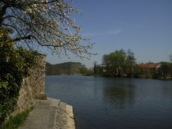 The Naab near Kallmünz | |
| Location | |
| Country | Germany |
| State | Bavaria |
| Physical characteristics | |
| Source | |
| • location | Fichtelgebirge |
| Mouth | |
• location | Danube |
• coordinates | 49°1′0″N 12°1′53″E / 49.01667°N 12.03139°ECoordinates: 49°1′0″N 12°1′53″E / 49.01667°N 12.03139°E |
| Length | 97.5 km (61 mi) [1] |
| Basin size | 5,514 km2 (2,129 sq mi) [1] |
| Basin features | |
| Progression | Danube→ Black Sea |

The Naab (Czech: Nába) is a river in Bavaria, Germany, and is a left tributary of the Danube. Including its main source river Waldnaab, it is 196.6 km (122 mi) long.[1]
The Naab is formed by the confluence of the Waldnaab and the Haidenaab in Luhe-Wildenau, south of Weiden in der Oberpfalz. It flows generally south, through the towns Nabburg, Schwandorf and Burglengenfeld. It flows into the Danube near Regensburg.
See also[]
References[]
- ^ Jump up to: a b c Complete table of the Bavarian Waterbody Register by the Bavarian State Office for the Environment (xls, 10.3 MB)
Sources[]
- Die Naab – mit Waldnaab, Fichtelnaab, Haidenaab. (2004) Luftbildband, 132 Seiten, Pustet, Regensburg, 2004. ISBN 3-7917-1915-7
- Die Naab – Leben am Fluß im Wandel der Zeit. (1998) Buch & Kunstverlag Oberpfalz, Amberg,´ISBN 3-924350-93-0
External links[]
| Authority control |
|---|
Categories:
- Tributaries of the Danube
- Naab basin
- Rivers of Bavaria
- Rivers of the Upper Palatine Forest
- Rivers of Germany
- Bavaria river stubs