Weiden in der Oberpfalz
Weiden in der Oberpfalz | |
|---|---|
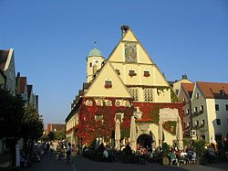 Old Town Hall | |
 Flag  Coat of arms | |
show Location of Weiden in der Oberpfalz | |
 Weiden in der Oberpfalz | |
| Coordinates: 49°40′N 12°09′E / 49.667°N 12.150°ECoordinates: 49°40′N 12°09′E / 49.667°N 12.150°E | |
| Country | Germany |
| State | Bavaria |
| Admin. region | Upper Palatinate |
| District | Urban district |
| Government | |
| • Lord mayor (2020–26) | Jens Meyer[1] (SPD) |
| Area | |
| • Total | 68.50 km2 (26.45 sq mi) |
| Elevation | 397 m (1,302 ft) |
| Population (2020-12-31)[2] | |
| • Total | 42,535 |
| • Density | 620/km2 (1,600/sq mi) |
| Time zone | UTC+01:00 (CET) |
| • Summer (DST) | UTC+02:00 (CEST) |
| Postal codes | 92637 |
| Dialling codes | 0961 |
| Vehicle registration | WEN |
| Website | www.weiden.de |


Weiden in der Oberpfalz (official name: Weiden i.d.OPf.; Northern Bavarian: Weidn in da Owapfalz) is a district-free city in Bavaria, Germany. It is located 100 km (62 mi) east of Nuremberg and 35 km (22 mi) west of the Czech border. A branch of the German Army is located here.
History[]
Weiden in der Oberpfalz was first mentioned in a document in 1241 as Weiden. It is assumed that the first settlements in Weiden are dated the year 1000. Located at the intersection of two major trading routes (Goldene Strasse and Magdeburger Strasse), Weiden soon became an important trading center with a population of 2,200 in 1531. An economic boom came along in 1863 when Weiden was connected to the railroad network. Some major companies of the glass and china industry settled in Weiden and the population increased.
Districts[]
- 01 Altstadt
- 02 Scheibe
- 03 Hammerweg
- 04 Weiden-Ost II
- 05 Weiden-Ost I
- 06 Bahnhof-Moosbürg
- 07 Fichtenbühl
- 08 Stockerhut
- 09 Lerchenfeld
- 10 Weiden-West
- 11 Rehbühl
- 12 Mooslohe
- 13 Neunkirchen
- 14 Rothenstadt
- 15 Weiden-Land
Incorporations into Weiden in der Oberpfalz[]
- January 1, 1914, Moosbürg, district of Moosbürg, Ermersricht, Fichtenbühl, Leihstadtmühle
- February 1, 1915, Tröglersricht and Zollhaus
- July 1, 1972, Frauenricht, district of Frauenricht, Halmesricht, Latsch, Spitalöd
- July 1, 1972, Muglhof, district of Muglhof, Matzlesrieth, Mitterhöll, Unterhöll, Oedentahl, Trauschendorf
- July 1, 1972, Neunkirchen bei Weiden, district of Neunkirchen, Brandweiher, Wiesendorf
- May 1, 1978, Rothenstadt, district of Rothenstadt, Maierhof, Mallersricht, Neubau Ullersricht
- May 1, 1978, Moosöd
Main sights[]
Historical buildings[]
- St. Josef. Catholic church, built 1899–1900, Neo Romanesque style with art nouveau interior.
- Marktplatz, the market square stretched between Upper and Lower Gates with numerous renaissance buildings.
- Altes Rathaus ("Old Town Hall"), built between 1539 and 1545 by .
- . A Protestant church, rebuilt several times. The church got its present baroque appearance from 1627, the tower from 1761.
- Alte Stadtmauer, partially preserved old city walls from the 14th century.
- St. Sebastian Kirche. Catholic chapel, built around 1480.
Museums[]
- International Ceramic Museum
- City Museum - exhibits art, furniture and porcelain from the early 16th century to the 19th century. There is a room dedicated to composer Max Reger, that lived and studied in Weiden.
Twin towns – sister cities[]
Weiden in der Oberpfalz is twinned with:[3]
 Issy-les-Moulineaux, France (1962)
 Macerata, Italy (1963)
 Weiden am See, Austria (1990)
 Annaberg-Buchholz, Germany (1990)
 Mariánské Lázně, Czech Republic (2008)
Geography[]
Climate[]
This area is characterized by equable climates with few extremes of temperature and ample precipitation in all months. The Köppen Climate Classification subtype for this climate is "Cfb". (Marine West Coast Climate).[4]
| hideClimate data for Weiden in der Oberpfalz | |||||||||||||
|---|---|---|---|---|---|---|---|---|---|---|---|---|---|
| Month | Jan | Feb | Mar | Apr | May | Jun | Jul | Aug | Sep | Oct | Nov | Dec | Year |
| Average high °C (°F) | 1 (33) |
2 (36) |
8 (47) |
14 (57) |
18 (65) |
22 (71) |
23 (74) |
24 (75) |
19 (66) |
13 (56) |
6 (42) |
2 (36) |
13 (55) |
| Daily mean °C (°F) | −2 (28) |
−1 (30) |
3 (38) |
8 (46) |
12 (54) |
16 (60) |
17 (62) |
17 (62) |
13 (56) |
8 (47) |
3 (37) |
0 (32) |
8 (46) |
| Average low °C (°F) | −4 (24) |
−4 (25) |
−2 (29) |
2 (36) |
6 (43) |
9 (49) |
11 (51) |
10 (50) |
8 (46) |
3 (38) |
1 (33) |
−2 (29) |
3 (38) |
| Average precipitation cm (inches) | 5.1 (2) |
3.8 (1.5) |
4.1 (1.6) |
5.1 (2) |
6.1 (2.4) |
6.6 (2.6) |
8.9 (3.5) |
7.6 (3) |
5.8 (2.3) |
4.8 (1.9) |
4.6 (1.8) |
5.6 (2.2) |
68 (26.8) |
| Source: Weatherbase [5] | |||||||||||||
Notable people[]
- Erhard Weigel (1625–1699), astronomer and mathematician
- Franz Ferdinand von Rummel (1644–1716), Prince-Bishop in Vienna
- Max Reger (1873–1916), composer and organist
- Eduard Zintl (1898–1941), chemist
- Otto Ambros (1901–1990), chemist
- Martin Gottfried Weiss (1905–1946), SS Commander of German concentration camps executed for war crimes
- Elisabeth Schärtel (1919–2012), mezzo-soprano
- Erich Bäumler (1930–2003), footballer
- Marga Schiml (born 1945), opera singer
- Monika Henzinger (born 1966), computer scientist
- Michael Brenner (born 1964), historian
- Benedikt Schopper (born 1985), ice hockey player
- Nadine Kraus (born 1988), footballer
- Sven Kopp (born 1995), footballer
- Dennis Lippert (born 1996), footballer
Notes[]
- ^ Liste der Oberbürgermeister in den kreisfreien Städten, accessed 19 July 2021.
- ^ "Tabellenblatt "Daten 2", Statistischer Bericht A1200C 202041 Einwohnerzahlen der Gemeinden, Kreise und Regierungsbezirke". Bayerisches Landesamt für Statistik (in German). June 2021.
- ^ "Partnerstädte". weiden.de (in German). Weiden in der Oberpfalz. Retrieved 2021-02-17.
- ^ "Weiden, Germany Köppen Climate Classification (Weatherbase)". Weatherbase. Archived from the original on 4 March 2016. Retrieved 24 April 2018.
- ^ "Weatherbase.com". Weatherbase. 2013. Archived from the original on 2016-03-04. Retrieved on May 8, 2013.
External links[]
| Wikimedia Commons has media related to Weiden in der Oberpfalz. |
- Official website
 (in German)
 - Webcams in Weiden
- Website on St. Josef Church, including pictures and a guide
| show Authority control |
|---|
- Towns in Bavaria