Neuburg-Schrobenhausen
Neuburg-Schrobenhausen | |
|---|---|
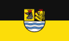 Flag 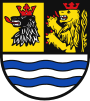 Coat of arms | |
 | |
| Country | Germany |
| State | Bavaria |
| Adm. region | Upper Bavaria |
| Capital | Neuburg an der Donau |
| Area | |
| • Total | 740 km2 (290 sq mi) |
| Population (31 December 2020)[1] | |
| • Total | 97,730 |
| • Density | 130/km2 (340/sq mi) |
| Time zone | UTC+01:00 (CET) |
| • Summer (DST) | UTC+02:00 (CEST) |
| Vehicle registration | ND, SOB |
| Website | neuburg-schrobenhausen.de |
Neuburg-Schrobenhausen is a Landkreis (district) in Bavaria, Germany. It is bounded by (from the east and clockwise) the districts of Pfaffenhofen, Aichach-Friedberg, Donau-Ries and Eichstätt, and by the city of Ingolstadt.
History[]
The district was established in 1972 by merging the former districts of Neuburg and Schrobenhausen.
Geography[]

Aresing, ND - Oberlauterbach östl - Paartal 01
The district consists of the previously swampy areas between the Danube and Paar rivers, that are called the Donaumoos. North of the Danube the district includes a small part of the Altmühl Valley Nature Park.
Coat of arms[]
The coat of arms displays:
- the bear's head from the city arms of Schrobenhausen
- the heraldic lion of the Electorate of the Palatinate
- a wavy line symbolising the Danube River
Towns and municipalities[]

Towns and municipalities in Landkreis Neuburg-Schrobenhausen
| Towns | Municipalities | |
|---|---|---|
References[]
External links[]
| Wikimedia Commons has media related to Landkreis Neuburg-Schrobenhausen. |
- Official website (German)
| show Towns and municipalities in Neuburg-Schrobenhausen |
|---|
Coordinates: 48°40′N 11°10′E / 48.67°N 11.17°E

| show Authority control |
|---|
Categories:
- Districts of Bavaria
- Neuburg-Schrobenhausen