Neu-Ulm (district)
Neu-Ulm | |
|---|---|
 Flag  Coat of arms | |
 | |
| Country | Germany |
| State | Bavaria |
| Adm. region | Swabia |
| Capital | Neu-Ulm |
| Government | |
| • District admin. | Thorsten Freudenberger (CSU) |
| Area | |
| • Total | 515 km2 (199 sq mi) |
| Population (31 December 2020)[1] | |
| • Total | 175,823 |
| • Density | 340/km2 (880/sq mi) |
| Time zone | UTC+01:00 (CET) |
| • Summer (DST) | UTC+02:00 (CEST) |
| Vehicle registration | NU |
| Website | landkreis.neu-ulm.de |
Neu-Ulm is a Landkreis (district) in Swabia, Bavaria, Germany. It is bounded by (from the east and clockwise) the districts of Günzburg and Unterallgäu and the state of Baden-Württemberg (districts Biberach and Alb-Donau, city of Ulm).
The district was established in 1972 by merging the former districts of Neu-Ulm and Illertissen with the previously district-free city of Neu-Ulm.
The district includes the eastern metropolitan area of the city of Ulm. The Danube and its tributary, the Iller, form the western border of the district.
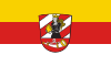
Coat of arms[]
The coat of arms displays:
- the moor from the arms of Kirchberg
- the horn from the arms of Neuffen
Towns and municipalities[]
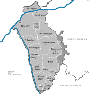
Towns and municipalities in Landkreis Neu-Ulm
| Towns | Municipalities | |
|---|---|---|
|
References[]
External links[]
| Wikimedia Commons has media related to Landkreis Neu-Ulm. |
- Official website (German)
| show Towns and municipalities in Neu-Ulm (district) |
|---|
Coordinates: 48°20′N 10°10′E / 48.333°N 10.167°E

| show Authority control |
|---|
This Neu-Ulm district location article is a stub. You can help Wikipedia by . |
Categories:
- Districts of Bavaria
- Neu-Ulm (district)
- Mittelschwaben
- Swabia (Bavaria)
- Swabia (Bavaria) geography stubs