Mühldorf (district)
Mühldorf | |
|---|---|
 Flag 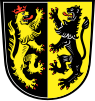 Coat of arms | |
 | |
| Country | Germany |
| State | Bavaria |
| Adm. region | Upper Bavaria |
| Capital | Mühldorf |
| Area | |
| • Total | 805.32 km2 (310.94 sq mi) |
| Population (31 December 2020)[1] | |
| • Total | 116,483 |
| • Density | 140/km2 (370/sq mi) |
| Time zone | UTC+01:00 (CET) |
| • Summer (DST) | UTC+02:00 (CEST) |
| Vehicle registration | MÜ |
| Website | landkreis-muehldorf.de |
Mühldorf is a Landkreis (district) in Upper Bavaria, Germany. It is bounded by (from the north and clockwise) the districts of Landshut, Rottal-Inn, Altötting, Traunstein, Rosenheim, Ebersberg and Erding.
History[]
Most parts of the district have belonged to Bavaria from the 13th century on. The archbishopric of Salzburg possessed some estates in the region as well from the year 798.[2] In 1803, when the clerical states of Holy Empire were dissolved, Bavaria annexed these estates.
Geography[]
The district is located in generally plain countryside on either bank of the river Inn.
Coat of arms[]
The coat of arms displays:
- the heraldic lion of Salzburg
- the heraldic lion of the Electorate of the Palatinate
Towns and municipalities[]

| Towns | Municipalities | |
|---|---|---|
References[]
- ^ "Tabellenblatt "Daten 2", Statistischer Bericht A1200C 202041 Einwohnerzahlen der Gemeinden, Kreise und Regierungsbezirke". Bayerisches Landesamt für Statistik (in German). June 2021.
- ^ Freed, p. 13
Bibliography[]
Freed, John B. Noble Bondsmen: Ministerial Marriages in the Archdiocese of Salzburg, 1100-1343. (Ithaca, NY: Cornell University Press, 1995).
External links[]
| Wikimedia Commons has media related to Landkreis Mühldorf am Inn. |
- Official website (German)
| show Towns and municipalities in Mühldorf district |
|---|
Coordinates: 48°15′N 12°25′E / 48.25°N 12.42°E

| Authority control |
|---|
- Districts of Bavaria
- Mühldorf (district)