Nanisivik
Nanisivik | |
|---|---|
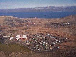 Aerial view of Nanisivik | |
 Nanisivik | |
| Coordinates: 73°02′N 84°33′W / 73.033°N 84.550°WCoordinates: 73°02′N 84°33′W / 73.033°N 84.550°W | |
| Country | Canada |
| Territory | Nunavut |
| Region | Qikiqtaaluk |
| Highest elevation | 341 m (1,119 ft) |
| Lowest elevation | 0 m (0 ft) |
| Population (2016)[1] | |
| • Total | 0 |
| Time zone | UTC−05:00 (EST) |
| • Summer (DST) | UTC−04:00 (EDT) |
| Postal Code | X0A 0X0 |
| GNBC Code | OALHI |
| NTS Map | 048C01 |


Nanisivik (Inuktitut: ᓇᓂᓯᕕᒃ, lit. 'the place where people find things'; /nəˈniːsɪvɪk/) was a company town which was built in 1975 to support the lead-zinc mining and mineral processing operations for the Nanisivik Mine, in production between 1976 and 2002. The townsite was located just inland from , about 20 km (12 mi) east of the community of Arctic Bay in the Canadian territory of Nunavut.
There is a port and dock about 3.7 km (2.3 mi) north of the former mine site which was used for shipping concentrate from the site, and receiving supplies (73°04′08″N 084°32′57″W / 73.06889°N 84.54917°W). It is currently used by the Canadian Coast Guard for training.[2]
Nanisivik Airport located 8 NM (15 km; 9.2 mi) south[3] was used as the main airport for Arctic Bay until 2010 when the lengthened Arctic Bay Airport took over. The airport is about 19 km (12 mi) directly southeast of Arctic Bay but the road between them is 32 km (20 mi).[4]
Geology[]
The ore deposit resides within dolomite from the Society Cliffs Formation covered with dolomitic shale from the Victor Bay Formation, which together form the Uluksan Group and reside on top of silty shale. The ore is believed to have formed when hot saline water bearing the metal ions of sodium, calcium, chlorine, and sulfate mixed with cooler carbonate-rich brine in the presence of natural gas or methane, which produced hydrogen sulfide through reducing the sulfate. The hydrogen sulfide then reacted with the metals to form the sulfides of marcasite (FeS2), pyrite (FeS
2), sphalerite ((Zn,Fe)S), and galena (PbS). The Nanisivik deposit once contained 60 million metric tons of pyrite and 12 million tons of lead-zinc ore.[5]
Mineralogy[]
The Nanisivik mine is known for its diversity of unusual pyrite pseudomorphs after marcasite and pyrrhotite.

History[]
Ore discovery[]
Arthur English was a prospector on CGS Arctic, the steamship of Captain Joseph-Elzéar Bernier, as part of the Geological Survey of Canada in 1910. They wintered the 1910-11 winter in Arctic Bay (20 km (12 mi) south-east of Nanisivik). In 1911 Arthur English published his discovery of a "very large body of ore" at Nanisivik.[5]
Development[]
J.F. Tibbitt and F. McInnes travelled from Churchill, Manitoba to Nanisivik by dog sled (3,000 km [1,900 mi]) and staked their claims in 1937, but were unable to develop them. In 1956 R. G. Blackadar and R. R. H. Lemon published maps of the region for another Geological Survey of Canada. Soon thereafter Texas Gulf Sulfur Company (later Texasgulf Inc., now broken up into bits such as Intrepid Potash) evaluated the region and staked 15 claims. Extensive drilling and exploration over the next decade led to the procurement of heavy equipment in 1970 and bulk metallurgical testing. of Calgary, Alberta traded the rights to a sulfur deposit in Mexico for a long term option on the Strathcona Sound property, which eventually translated into 54% ownership of . Strathcona Mineral Services Limited was hired to run the mine as an independent manager and successfully initiated production.[5]
Operation[]
The mine opened in 1976 and yielded primarily zinc, however silver and lead were collected as by-products. It is located in 500 m (1,600 ft) thick permafrost, 700 km (430 mi) north of the Arctic Circle and operated year-round through accumulating ore during the winter and shipping in the summer (July-November). Annual production totalled 125,000 tons of ore, which was sold to European smelters via Belgium.
Conwest Exploration Company Ltd. eventually acquired the mine.[5]
Mine closure[]
Since the closure of the mine in 2002, reclamation has been ongoing and the town is abandoned. Residents of Arctic Bay had hoped that the Government of Nunavut would be able to find a new use for the former town site, potentially a trades training centre. They had also hoped to be able to move some of the buildings and equipment to their community.[6] Due to heavy lead-zinc contamination, this was not possible and the homes have been demolished.[7] Local telephone service was discontinued on February 19, 2007 on approval from CRTC.
As of the 2006 census the population was 0, a drop from the 2001 census with a population of 77.[8][9]
[]
On August 8, 2007, CBC News reported that Canadian Forces documents showed plans to convert the site into a naval station. The plan, which would turn the former mine's existing port into a deepwater facility, would cost $60 million and it was expected that Prime Minister Stephen Harper would make an announcement during his stop in Resolute.[10]
On August 10, 2007, Prime Minister Stephen Harper announced construction of a new docking and refuelling facility in Nanisivik for the Canadian Forces, in an effort to maintain a Canadian presence in Arctic waters during the navigable season (June–October). The choice for Nanisivik as a site was partially based on its location within the eastern entrance to the Northwest Passage, and the existence of a deep-water berthing facility at the site, as well as a "jet-capable" airstrip nearby.
Detailed planning for the project began in August 2007, with environmental studies and assessments being carried out in the summer of 2008. Construction at the site was originally expected to begin in the summer of 2010, with early operating capability available in 2012. The facility was planned to be fully operational by 2015.[11]
Once completed, the naval station will likely be home to the proposed Arctic Off-Shore Patrol Ships under the Harper government plan.[12][13] These ships will have ice-breaking capability and help the current government's goal to enforce Canada's sovereignty over the region. These ships will likely allow the Victoria-class submarines to travel in the Arctic regions.
The facility was to have an initial operational capability in 2012, and be fully complete in 2015 but is behind schedule.[14][15] Development is being delayed because environmental cleanup has been delayed as much as possible by Breakwater Resources Ltd., owned by Nyrstar N.V.[16]
In 2011 and 2012, the government started backing down on the Nanisivik conversion plans, explaining that construction in the far north is too expensive. The station will be primarily used for refuelling Arctic patrol and other government vessels, and construction was expected to begin in 2013, with the station operational by 2016.[17] After repeated delays, construction on the site finally commenced in 2015.[18] The station had been expected to be operational in summer 2019.[19]However, in July 2020 it was confirmed that the station would not now be fully operational until 2022. [20]
Geography[]
Climate[]
Nanisivik has a tundra climate (ET) with long, cold winters and very short, chilly summers that are rarely mild. Early winter tends to be snowiest period of the year, with around 40% of all yearly snowfall falling during this short period.
| hideClimate data for Nanisivik Airport | |||||||||||||
|---|---|---|---|---|---|---|---|---|---|---|---|---|---|
| Month | Jan | Feb | Mar | Apr | May | Jun | Jul | Aug | Sep | Oct | Nov | Dec | Year |
| Record high humidex | −3.0 | 1.2 | −2.2 | −1.2 | 6.5 | 14.5 | 18.4 | 16.7 | 9.0 | 1.2 | −6.3 | −1.3 | 18.4 |
| Record high °C (°F) | −2.0 (28.4) |
2.0 (35.6) |
−3.0 (26.6) |
−0.5 (31.1) |
7.0 (44.6) |
18.5 (65.3) |
18.2 (64.8) |
17.0 (62.6) |
8.5 (47.3) |
2.0 (35.6) |
−6.0 (21.2) |
−4.4 (24.1) |
18.5 (65.3) |
| Average high °C (°F) | −26.8 (−16.2) |
−27.2 (−17.0) |
−24.7 (−12.5) |
−16.6 (2.1) |
−7.6 (18.3) |
2.2 (36.0) |
7.5 (45.5) |
3.9 (39.0) |
−3.3 (26.1) |
−11.3 (11.7) |
−19.8 (−3.6) |
−23.6 (−10.5) |
−12.3 (9.9) |
| Daily mean °C (°F) | −29.6 (−21.3) |
−29.9 (−21.8) |
−27.6 (−17.7) |
−19.8 (−3.6) |
−10.3 (13.5) |
−0.1 (31.8) |
5.1 (41.2) |
1.7 (35.1) |
−5.0 (23.0) |
−13.6 (7.5) |
−22.5 (−8.5) |
−26.3 (−15.3) |
−14.8 (5.4) |
| Average low °C (°F) | −32.4 (−26.3) |
−32.3 (−26.1) |
−30.1 (−22.2) |
−22.9 (−9.2) |
−13.0 (8.6) |
−2.4 (27.7) |
2.7 (36.9) |
−0.5 (31.1) |
−6.7 (19.9) |
−15.8 (3.6) |
−24.9 (−12.8) |
−28.7 (−19.7) |
−17.2 (1.0) |
| Record low °C (°F) | −48.5 (−55.3) |
−53.0 (−63.4) |
−47.5 (−53.5) |
−42.0 (−43.6) |
−28.3 (−18.9) |
−14.0 (6.8) |
−6.0 (21.2) |
−10.0 (14.0) |
−19.5 (−3.1) |
−35.0 (−31.0) |
−39.4 (−38.9) |
−45.5 (−49.9) |
−53.0 (−63.4) |
| Record low wind chill | −62.9 | −72.3 | −67.0 | −54.8 | −39.4 | −24.9 | −12.8 | −21.0 | −30.3 | −50.0 | −53.5 | −60.6 | −72.3 |
| Average precipitation mm (inches) | 5.4 (0.21) |
5.1 (0.20) |
8.4 (0.33) |
10.9 (0.43) |
24.0 (0.94) |
25.2 (0.99) |
45.7 (1.80) |
45.0 (1.77) |
38.4 (1.51) |
37.4 (1.47) |
18.1 (0.71) |
7.3 (0.29) |
270.9 (10.67) |
| Average rainfall mm (inches) | 0.0 (0.0) |
0.0 (0.0) |
0.0 (0.0) |
0.0 (0.0) |
0.1 (0.00) |
6.7 (0.26) |
37.0 (1.46) |
29.2 (1.15) |
4.4 (0.17) |
0.0 (0.0) |
0.0 (0.0) |
0.0 (0.0) |
77.3 (3.04) |
| Average snowfall cm (inches) | 5.4 (2.1) |
5.2 (2.0) |
8.4 (3.3) |
11.2 (4.4) |
24.0 (9.4) |
17.7 (7.0) |
8.5 (3.3) |
15.0 (5.9) |
32.3 (12.7) |
38.2 (15.0) |
17.9 (7.0) |
7.5 (3.0) |
191.3 (75.3) |
| Average precipitation days (≥ 0.2 mm) | 4.4 | 4.6 | 6.2 | 5.7 | 9.6 | 8.8 | 12.4 | 12.6 | 13.3 | 14.2 | 8.4 | 6.3 | 106.5 |
| Average rainy days (≥ 0.2 mm) | 0.0 | 0.0 | 0.0 | 0.0 | 0.0 | 2.2 | 10.4 | 8.1 | 1.7 | 0.0 | 0.0 | 0.0 | 22.3 |
| Average snowy days (≥ 0.2 cm) | 4.4 | 4.6 | 6.2 | 5.8 | 9.6 | 7.1 | 3.0 | 5.4 | 12.1 | 14.3 | 8.5 | 6.4 | 87.3 |
| Average relative humidity (%) | 64.1 | 65.0 | 66.6 | 71.2 | 81.3 | 80.7 | 75.6 | 84.9 | 88.6 | 89.7 | 72.9 | 68.7 | 75.8 |
| Source: Environment Canada Canadian Climate Normals 1981–2010[21] | |||||||||||||
Demographics[]
In the 2011 Census, Statistics Canada originally reported that Nanisivik had a population of 10 living in 4 of its 4 total dwellings, an increase from its 2006 population of 0.[22] Statistics Canada subsequently amended the 2011 census results to a population of 0 living in 0 of its 4 total dwellings.[1] It has a land area of 165.04 km2 (63.72 sq mi).[22]
References[]
- ^ Jump up to: a b "Corrections and updates". Statistics Canada. March 21, 2013. Retrieved June 15, 2013.
- ^ "Arcticnet - Naval gazing: Looking for a High Arctic port". Archived from the original on 2007-07-15. Retrieved 2007-08-07.
- ^ Canada Flight Supplement. Effective 0901Z 16 July 2020 to 0901Z 10 September 2020.
- ^ Arctic Bay and Nanisivik Archived 2007-09-27 at the Wayback Machine
- ^ Jump up to: a b c d Gait, Robert I., George W. Robinson, Karen Bailey, and Doug Dumka. Minerals of The Nanisivik Mine Nov-Dec 1990 (Volume 21, Number 6) The Mineralogical Record. N.p., 05 Oct. 2011. Web. 03 Sept. 2013.
- ^ "Arctic Bay impatient with slow Nanisivik transfer talks". Archived from the original on 2007-09-27. Retrieved 2007-08-17.CS1 maint: bot: original URL status unknown (link)
- ^ "CBC - Contamination concerns grow at Nanisivik". CBC News. 2004-06-04. Archived from the original on 2013-01-01. Retrieved 2007-08-17.
- ^ "Stats Canada - 2006 Community Profiles". 2007-03-13. Archived from the original on 2013-01-15. Retrieved 2007-08-07.
- ^ "Stats Canada 2001 Data". Archived from the original on 2016-02-15. Retrieved 2007-08-07.CS1 maint: bot: original URL status unknown (link)
- ^ > "Planned army base, port in North heat up Arctic quest". CBC News. 2007-08-08. Archived from the original on 2008-01-18. Retrieved 2008-08-10.
- ^ "Backgrounder - Expanding Canadian Forces Operations in the Arctic". Archived from the original on 2008-08-11. Retrieved 2007-08-17.
- ^ "Nanisivik Naval Facility: Project Summary" (PDF). Department of National Defence. 2009-03-26. Retrieved 2009-10-23.[dead link]
- ^ "Nanisivik Naval Facility Project: Overview Presentation to Stakeholders – 27 October 08" (PDF). Department of National Defence. 2008-10-27. Retrieved 2009-10-23.[dead link]
- ^ Al Blondin (2007-09-05). "Breaking the ice to Nanisivik" (PDF). The Maple Leaf. Archived from the original (PDF) on 2011-06-09. Retrieved 2009-10-23.
- ^ Al Blondin (2007-09-05). "New deep water facility to support Arctic offshore patrol ships" (PDF). The Maple Leaf. Archived from the original (PDF) on 2011-06-09. Retrieved 2009-10-23.
- ^ Brewster, Murray (September 1, 2013). "Harper's vaunted Arctic naval refuelling station going nowhere fast". The Globe and Mail. Ottawa. The Canadian Press.
- ^ "Arctic naval facility downgrade due to high cost, says DND". Retrieved 2012-11-05.
- ^ "Nanisivik, Nunavut, naval facility breaks ground". CBC News. 2015-07-18. Retrieved 2016-05-04.
- ^ Coleman, Linda (7 September 2018). "Operation NANOOK 2018: Canadian Armed Forces strengthen joint Arctic capabilities". Royal Canadian Navy. Archived from the original on 26 November 2018. Retrieved 26 November 2018.
- ^ https://www.miragenews.com/canada-receives-first-new-arctic-and-offshore-patrol-ship/
- ^ "Nanisivik A" (CSV (4222 KB)). Canadian Climate Normals 1981–2010. Environment Canada. Climate ID: 2402730. Retrieved 2013-11-27.[permanent dead link]
- ^ Jump up to: a b "Population and dwelling counts, for Canada, provinces and territories, and census subdivisions (municipalities), 2011 and 2006 censuses (Nunavut)". Statistics Canada. January 30, 2013. Retrieved June 15, 2013.
External links[]
- Government will continue seeking positive legacy from Nanisivik mine closure, minister says. Government of Nunavut. October 1, 2002. Last accessed September 12, 2006.
- Welcome to the Arctic Bay & Nanisivik, Nunavut Photo Album!. Photographs by Vincent K. Chan. Last accessed September 12, 2006.
- "Arctic Bay and Nanisivik 2007" (PDF). 2007. Retrieved 2009-10-23.[permanent dead link]
- Baffin Island
- Company towns in Canada
- Mining communities in Nunavut
- Ports and harbours of Nunavut
- Ghost towns in Nunavut
- Former populated places in Arctic Canada
- Former populated places in the Qikiqtaaluk Region
- Road-inaccessible communities of Nunavut