Narooma, New South Wales
| Narooma New South Wales | |
|---|---|
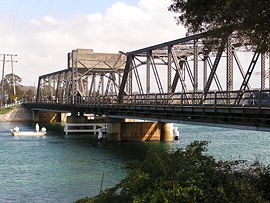 Bridge at Narooma on the Princes Highway | |
 Narooma | |
| Coordinates | 36°12′S 150°08′E / 36.200°S 150.133°ECoordinates: 36°12′S 150°08′E / 36.200°S 150.133°E |
| Population | 3,342 (2016 census)[1] |
| Established | 1881 |
| Postcode(s) | 2546 |
| Location | |
| LGA(s) | Eurobodalla Shire |
| County | Dampier |
| State electorate(s) | Bega |
| Federal Division(s) | Eden-Monaro |

Narooma is a town in the Australian state of New South Wales on the far south coast. The town is on the Princes Highway, which crosses the Wagonga Inlet to North Narooma. The heritage town of Central Tilba is nearby to the south.
The name Narooma is said to be derived from a word in the local Aboriginal language (one of the Yuin dialects) meaning "clear blue waters".
At the 2016 census, Narooma had an urban population of over 3,000 people.
History[]


Before European settlement of the area, the Yuin people inhabited the lands along the stretch of coast,[3] with the Walbunga/Walbunja clan being the traditional owners of the Narooma area.[4] The name Narooma is said to be derived from a word in the local Aboriginal language meaning "clear blue waters".[5][6] The language of the Walbunja was probably a dialect of Dhurga.[7]
There had been an earlier settlement nearby at Punkalla, which was a port for Bodalla and Nerrigundah; a ruined jetty and timber mill can still be seen there. Gold was discovered nearby at Central Tilba in 1880[citation needed] and a post office was opened at present-day (to the south, in Eurobodalla Shire), named "Noorooma".[5]
A township was surveyed at the present location of Narooma in 1883 and given the name Noorooma, which it held until 1972. It was declared a port in 1884.[8][5]
Its school opened in 1886 and its post office in 1889.[8] Transport to Narooma was first from the sea. From 1894 a hand-worked punt crossed Wagonga Inlet, linking Narooma to North Narooma and on to Moruya.[9] A daily mail coach ran through the town between Bega and Moruya.[10]
Narooma was regarded as a tourist destination from the early twentieth century. The local oyster industry was established around 1900. The Uniting (formerly Methodist) Church on the Princes Highway dates from 1914.[8] Together with the associated parsonage, it is regarded as an excellent example of the Australian Federation Carpenter Gothic architectural style.
In 1929 a petrol-driven punt that had previously operated at Batemans Bay was installed. The Narooma bridge was the first major bridge constructed on the Princes Highway by the Main Roads Board as part of its efforts to develop the highway. The bridge was built between 1929 and 1931 and crosses the Wagonga Inlet. The bridge has three spans and is made of steel and concrete. It is one of two bascule span bridges of its type remaining in New South Wales in 2002; the other was being threatened with demolition in 2002. A footpath was added to the eastern (seaward) side of the bridge in 1960.[10]
A fish cannery opened in 1937[11][12] or 1940[8] to process tuna and salmon.
In 1972 the name was officially changed from Noorooma to Narooma.[5]
Geology[]
Narooma is located on the Narooma Terrane, which used to be separated by thousands of kilometres from the Australian coast. It travelled to the west and attached itself to the side of the Lachlan Fold Belt, which became part of Australia. The rock found near Narooma includes the Narooma Chert dating from Cambrian times, and turbidites. There are also the remains of a submarine volcano with pillow lava.[citation needed]
Demography[]
At the 2016 census, Narooma had an urban population of over 3,000 people.[1]
Attractions and landmarks[]


Montague Island, a National Parks and Wildlife Reserve, is eight kilometres offshore from Narooma. Charter operators tour from Narooma onto and around the island.[13]
Gulaga, until recently also known as Mt. Dromedary, the name given by Captain Cook for its resemblance to the dromedary camel, can be reached from the village of Tilba Tilba. There are eight rainforest types on the mountain, and rock sites of significance to the local indigenous population. Views from the top of the mountain are limited by the vegetation. Beaches in the area include Dalmeny Beach, Narooma Beach, Bar Beach (flat water) and Yabarra Beach.
Australia Rock is found at the bar crossing (where the inlet empties into the sea). The shape of Australia cut into the rock wall was accidental and was created many years ago when a ship was tied to the rock with large chains to prevent it from washing away. The chains wore the shape into the rock during rough seas and it has been known as Australia Rock ever since.[14]
The Narooma Golf Course was established in 1930 and has been rated amongst Australia's top 50 public access courses and Australia's top 25 resort golf courses.[15] It is considered to be a spectacular and challenging course, with views of Montague Island to the east and Glass House Rocks to the south.
The Great Southern Blues Festival was held here annually on the October Long Weekend until it moved to Batemans Bay in 2010. The festival returned to Narooma in 2013, and continued to be held each year on the October Long Weekend until it ceased in 2015.[16]
Climate[]
Narooma has an oceanic climate (Cfb) with lukewarm summers and mild winters. It is fairly sunny, getting 98.4 clear days annually. The town's drier winters are owed to its position on the leeward side of the Great Dividing Range, which block moisture from the westerly cold fronts that arrive from the Southern Ocean and therefore they would become Foehn winds as they reach the coastal plain.[17]
| hideClimate data for Narooma, New South Wales (1910-2012) | |||||||||||||
|---|---|---|---|---|---|---|---|---|---|---|---|---|---|
| Month | Jan | Feb | Mar | Apr | May | Jun | Jul | Aug | Sep | Oct | Nov | Dec | Year |
| Record high °C (°F) | 43.5 (110.3) |
39.8 (103.6) |
38.9 (102.0) |
32.2 (90.0) |
25.6 (78.1) |
23.2 (73.8) |
24.8 (76.6) |
27.5 (81.5) |
33.9 (93.0) |
36.2 (97.2) |
38.4 (101.1) |
39.5 (103.1) |
43.5 (110.3) |
| Average high °C (°F) | 23.6 (74.5) |
23.6 (74.5) |
22.7 (72.9) |
21.1 (70.0) |
18.7 (65.7) |
16.7 (62.1) |
16.0 (60.8) |
16.8 (62.2) |
18.2 (64.8) |
19.3 (66.7) |
20.6 (69.1) |
21.9 (71.4) |
19.9 (67.8) |
| Average low °C (°F) | 16.5 (61.7) |
16.7 (62.1) |
15.4 (59.7) |
13.0 (55.4) |
10.1 (50.2) |
7.8 (46.0) |
6.7 (44.1) |
7.3 (45.1) |
9.0 (48.2) |
11.2 (52.2) |
13.2 (55.8) |
15.0 (59.0) |
11.8 (53.2) |
| Record low °C (°F) | 9.4 (48.9) |
10.0 (50.0) |
7.0 (44.6) |
6.1 (43.0) |
0.0 (32.0) |
1.1 (34.0) |
0.6 (33.1) |
0.5 (32.9) |
0.8 (33.4) |
2.0 (35.6) |
5.0 (41.0) |
7.5 (45.5) |
0.0 (32.0) |
| Average precipitation mm (inches) | 90.2 (3.55) |
93.5 (3.68) |
105.1 (4.14) |
79.4 (3.13) |
78.4 (3.09) |
87.1 (3.43) |
50.1 (1.97) |
50.5 (1.99) |
60.0 (2.36) |
71.2 (2.80) |
73.0 (2.87) |
73.5 (2.89) |
912.0 (35.91) |
| Average precipitation days | 9.9 | 9.5 | 10.4 | 8.3 | 7.9 | 8.8 | 6.7 | 7.1 | 8.6 | 10.5 | 10.9 | 10.5 | 109.1 |
| Average afternoon relative humidity (%) | 74 | 74 | 71 | 68 | 65 | 62 | 60 | 58 | 63 | 70 | 72 | 73 | 68 |
| Source: The Bureau of Meteorology[18] | |||||||||||||
References[]
- ^ Jump up to: a b Australian Bureau of Statistics (27 June 2017). "Narooma (Urban Centre)". 2016 Census QuickStats. Retrieved 3 December 2017.

- ^ "www.lovenarooma.com". Driving distances. Elise International Research. 2015. Archived from the original on 18 May 2015. Retrieved 10 May 2015.
- ^ Horton, David R. (1996). "Map of Indigenous Australia". AIATSIS. Retrieved 19 August 2021.
- ^ "Our Culture and Heritage". Wagonga Local Aboriginal Land Council. Retrieved 20 August 2021.
- ^ Jump up to: a b c d "Narooma, NSW". Aussie Towns. Retrieved 19 August 2021.
- ^ Verass, Sophie. "Indigenous meanings of Australian town names". NITV. Retrieved 20 August 2021.
- ^ S53 Dhurga at the Australian Indigenous Languages Database, Australian Institute of Aboriginal and Torres Strait Islander Studies
- ^ Jump up to: a b c d "Narooma". Walkabout. John Fairfax. Archived from the original on 23 March 2006. Retrieved 30 January 2006.
- ^ "Concluding - The Development of Prince's Highway - South Coast Times and Wollongong Argus (NSW : 1900 - 1954) - 11 Jun 1951". Trove. Retrieved 25 August 2016.
- ^ Jump up to: a b "Narooma Bridge". Heritage and conservation register. Roads and Traffic Authority of New South Wales. 2002. Retrieved 30 January 2006.
- ^ "Victoria Creek Bridge", Roads and Traffic Authority (NSW), 30 March 2004.
- ^ Maritime heritage online - South east, Heritage Office NSW, 2001.
- ^ "Montague Island". Eurobodalla Tourism. Retrieved 8 June 2016.
- ^ "Narooma NSW Attractions". Highway Traveller. Retrieved 8 June 2016.
- ^ "Narooma Golf Course". The Great Outdoors. au.travel.yahoo.com. December 2004. Retrieved 13 April 2008.
- ^ "Great Southern Blues Fest To Return In 2016 As New Event". TheMusic.com.au. 17 November 2015. Retrieved 8 June 2016.
- ^ Sharples, J.J. Mills, G.A., McRae, R.H.D., Weber, R.O. (2010) Elevated fire danger conditions associated with foehn-like winds in southeastern Australia. Journal of Applied Meteorology and Climatology.
- ^ "Climate Statistics for Narooma, New South Wales". Retrieved 12 May 2012.
External links[]
![]() Media related to Narooma, New South Wales at Wikimedia Commons
Media related to Narooma, New South Wales at Wikimedia Commons
| show Authority control |
|---|
- Towns in New South Wales
- Towns in the South Coast (New South Wales)
- 1881 establishments in Australia
- Populated places established in 1881
- Eurobodalla Shire
- Coastal towns in New South Wales