Narraweena, New South Wales
| Narraweena Sydney, New South Wales | |||||||||||||||
|---|---|---|---|---|---|---|---|---|---|---|---|---|---|---|---|
| Population | 6,608 (2016 census)[1] | ||||||||||||||
| Postcode(s) | 2099 | ||||||||||||||
| Location | 18 km (11 mi) north-east of Sydney CBD | ||||||||||||||
| LGA(s) | Northern Beaches Council | ||||||||||||||
| State electorate(s) | Wakehurst | ||||||||||||||
| Federal Division(s) | |||||||||||||||
| |||||||||||||||

Narraweena is a suburb of northern Sydney, in the state of New South Wales, Australia. Narraweena is 18 kilometres north-east of the Sydney central business district, in the local government area of Northern Beaches Council and is part of the Northern Beaches region.
Narraweena has two primary schools; Narraweena Public School and St John the Apostle Narraweena Catholic School.
History[]
Narraweena is an Aboriginal name meaning a quiet place in the hills.[citation needed] The suburb developed after World War II, when the land was subdivided, Narraweena Post Office opening on 1 April 1953.[2][3]
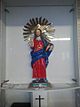
Italian people from Pazzano since the 1980s have organised an annual Santo Salvatore's fiest, with a statue very similar to the original that is taken from the catholic church of Narraweena around the suburb and back.
References[]
- ^ Australian Bureau of Statistics (27 June 2017). "Narraweena (NSW) (State Suburb)". 2016 Census QuickStats. Retrieved 15 March 2018.

- ^ Premier Postal History. "Post Office List". Premier Postal Auctions. Retrieved 12 June 2012.
- ^ The Book of Sydney Suburbs, Compiled by Frances Pollon, Angus & Robertson Publishers, 1990, Published in Australia ISBN 0-207-14495-8
Coordinates: 33°44′55″S 151°16′04″E / 33.74861°S 151.26778°E

This article related to the geography of Sydney is a stub. You can help Wikipedia by . |
- Suburbs of Sydney
- Northern Beaches Council
- Sydney geography stubs