Narsingdi District
Narsingdi
নরসিংদী | |
|---|---|
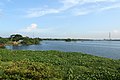
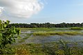
 Swamp in Narsingdi | |
 Location of Narsingdi District in Bangladesh | |
 Expandable map of Narsingdi District | |
| Coordinates: 23°55′N 90°44′E / 23.92°N 90.73°ECoordinates: 23°55′N 90°44′E / 23.92°N 90.73°E | |
| Country | |
| Division | Dhaka Division |
| Government | |
| • Deputy Commissioner | Syeda Farhana Kawnine |
| Area | |
| • Total | 1,140.76 km2 (440.45 sq mi) |
| Population (2011 census) | |
| • Total | 2,224,944 |
| • Density | 2,000/km2 (5,100/sq mi) |
| Time zone | UTC+06:00 (BST) |
| Postal code | 1600 |
| Website | Official website |

Narsingdi District (Bengali: নরসিংদী জেলা) is a district in central Bangladesh. It is located 50 km north-east of Dhaka, capital city of Bangladesh. It is a part of the Dhaka Division.[1] The district is famous for its textile craft industry. Narsingdi is bordered by Kishoreganj in the north and north-east, Brahmanbaria in the east and south-east, Comilla in the south and south-east, Narayanganj in the south and south-west and Gazipur in the west.
Subdivisions[]
There are six upazilas, or subdivisions, in the Narsingdi district.
- Belabo Upazila
- Monohardi Upazila
- Narsingdi Sadar Upazila
- Palash Upazila
- Raipura Upazila
- Shibpur Upazila
Demographics[]
At the 2011 census, the population was 2,224,944. 94.33% were Muslims, 5.65% Hindus.
Rivers[]
The Meghna, the Shitalakshya, the old Brahmaputra, , Haridhoa, and Paharea are some of the main rivers that flow through this district.
Gallery[]


See also[]
External links[]
| Wikimedia Commons has media related to Narsingdi District. |
References[]
- ^ Md. Mosharraf Hossain Sarkar (2012). "Narsingdi District". In Sirajul Islam and Ahmed A. Jamal (ed.). Banglapedia: National Encyclopedia of Bangladesh (Second ed.). Asiatic Society of Bangladesh.
- ^ "Bangladesh Population & Housing Census 2011" (PDF). Retrieved 6 July 2021.
| Rank | Name | Division | Pop. | Rank | Name | Division | Pop. | ||
|---|---|---|---|---|---|---|---|---|---|
 Dhaka  Chittagong |
1 | Dhaka | Dhaka | 8,906,039 | 11 | Savar | Dhaka | 296,851 |  Khulna  Sylhet |
| 2 | Chittagong | Chittagong | 2,592,439 | 12 | Comilla | Chittagong | 296,010 | ||
| 3 | Khulna | Khulna | 664,728 | 13 | Narayanganj | Dhaka | 286,330 | ||
| 4 | Sylhet | Sylhet | 531,663 | 14 | Siddhirganj | Dhaka | 256,760 | ||
| 5 | Rajshahi | Rajshahi | 451,425 | 15 | Jessore | Khulna | 237,478 | ||
| 6 | Tongi | Dhaka | 406,420 | 16 | Cox's Bazar | Chittagong | 223,522 | ||
| 7 | Bogra | Rajshahi | 400,983 | 17 | Gazipur | Dhaka | 213,061 | ||
| 8 | Mymensingh | Mymensingh | 389,918 | 18 | Brahmanbaria | Chittagong | 193,814 | ||
| 9 | Barisal | Barisal | 339,308 | 19 | Dinajpur | Rangpur | 191,329 | ||
| 10 | Rangpur | Rangpur | 307,053 | 20 | Narsingdi | Dhaka | 185,128 | ||
| show Authority control |
|---|
- ^ "National Volume-3: Urban Area Report" (PDF), Population and Housing Census 2011, Bangladesh Bureau of Statistics, pp. 24–25, August 2014
Categories:
- Narsingdi District
- Districts of Bangladesh