Rangpur, Bangladesh
This article needs additional citations for verification. (May 2021) |
Rangpur
রংপুর | |
|---|---|
Metropolitan City | |
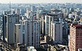
    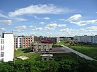  From top clockwise: Bird's eye view of Rangpur City at evening, Carmichael College, , Begum Rokeya University, Rangpur Town Hall, Public Library, Tajhat Palace | |
|
Seal | |
| Nickname(s): Green city | |
 Expandable map of Rangpur | |
 Rangpur Location in Rangpur Division, Bangladesh | |
| Coordinates: 25°34′N 89°15′E / 25.56°N 89.25°ECoordinates: 25°34′N 89°15′E / 25.56°N 89.25°E | |
| Country | |
| Division | Rangpur Division |
| District | Rangpur District |
| Municipality | 1 May 1869 |
| City Corporation | 28 June 2012 |
| Metropolitan City | 16 September 2018 |
| Government | |
| • Type | Mayor–Council |
| • Body | Rangpur City Corporation |
| • Mayor | Mostafizar Rahman Mostafa (Jatiya Party)[1] |
| Area | |
| • Urban | 47.67 km2 (18.41 sq mi) |
| • Metro | 239.72 km2 (92.56 sq mi) |
| Elevation | 34 m (111.549 ft) |
| Population (2017) | |
| • Rank | 5th in Bangladesh |
| • Density rank | 5th in Bangladesh |
| • Urban | 407,000 |
| • Urban density | 3,871/km2 (10,030/sq mi) |
| • Metro | 796,556 |
| • Metro density | 4,167/km2 (10,790/sq mi) |
| Demonym(s) | Rangpuria/Rongpuria (রংপুরিয়া) |
| Time zone | UTC+6 (BST) |
| Postal code | 5400[2] |
| Police | Rangpur Metropolitan Police |
| Calling Code | 521 |
| Website | rpcc |


Rangpur (/ˈrʌŋpʊər/, /rʌŋˈpʊər/; Bengali: রংপুর, romanized: Rongpur, lit. 'City of Colour') is one of the major cities in Bangladesh and Rangpur Division. Rangpur was declared a district headquarters on December 16, 1769, and established as a municipality in 1869, making it one of the oldest municipalities in Bangladesh.[3][4] The municipal office building was erected in 1892 under the precedence Raja Janaki Ballav, Senior Chairman of the municipality. In 1890, the Shyamasundari canal was excavated for the improvement of the town. Sharfuddin Ahmed Jhantu was first mayor of Rangpur City Corporation.
The city is located in the northwestern part of Bangladesh.[3] Begum Rokeya University is situated in the southern part of the city. Previously, Rangpur was the headquarters of the Greater Rangpur district. Later, the Greater Rangpur district was broken down into the Gaibandha, Kurigram, Lalmonirhat, Nilphamari and Rangpur districts. In the greater Rangpur region, little economic development took place until the 1990s, mainly because of the yearly flooding the region used to see before the building of the Teesta Barrage. Coal is found near this district. There is a large military cantonment in the vicinity of the city, along with a Ghagot park (under military surveillance), in addition to the famous Carmichael College and Rangpur Zoo in the city. Rangpur is also famous for its handicrafts industry like Shataranji which is recently declared as a GI product of Bangladesh.[5]
History[]
Etymology[]
It is said that the present name Rangpur came from the former 'Rongpur'. History has it that English colonial rulers in this region started cultivating Indigo. Due to the fertile soil in this region, Indigo cultivation was very much profitable. The locals knew that Indigo by the name of "Rongo". So thus, this Region was named "Rongopur".And from that, the name of today's Rangpur has originated. It is known from another conventional notion that the name Rangpur comes from the naming of Rangmahal (Palace of Entertainment) of Bhagadatta, son of Narakasura, king of Pragjyotisha Kingdom.[6]
Early History[]
According to Hindu theology, the eastern kingdom of Kamarupa or Pragjyotisha existed in India, which included the present Rangpur region. During the reign of King Bhagadatta (15th century BC) Rangpur belonged to Pragjyotisha Kingdom. During the reign of King Samudragupta (340 AD) Rangpur was considered a "Tax state" of Kamarupa.[7]
Mughal Period[]
According to Ain-i-Akbari, the Mughal period Rangpur consisted of three types of administrative areas. Rangpur was conquered by the army of Raja Man Singh, a commander of the Mughal emperor Akbar, in 1575, but it was not until 1686 it was fully integrated into the Mughal Empire. The Mughal Empire was established in the whole of Rangpur in 1611 AD. Place names Mughalbasa ("a locality of the Mughals"), and Mughalhat ("local market") organized by the Mughals bear testimony to the Mughal association and past of Rangpur and its hinterland. Later, Rangpur passed into the control of Sarker of Ghoraghat.[8]
British Period[]
After the East India Company gained "Deoani" in 1765, Rangpur came under British rule. The Fakir-Sannyasi rebellion took place in the Rangpur region, in which leaders like Fakir Majnu Shah played a key Role. The notable anti-colonialist rebel Devi Chaudhurani and Bhabani Pathak were from this region.[9] In the Sepoy Mutiny of 1857, the rebellious sepoys spread terror among the British rulers in the region. Later, in 1930, the first Civil disobedience movement was started in different parts of Rangpur on the call of Congress. A meeting of the peasant leaders of North Bengal was held here in October 1946 and the Tebhaga movement began in November.[10]
Pakistani Period and Liberation War[]
Rangpur was a District of East Pakistan Province during the Pakistani Period. People of Rangpur actively take part in different movements like Bengali language movement, Six point movement and 1969 Mass uprising. The first martyr from Rangpur in the liberation war was Sangku Samajhder, who was martyred on the date of 3 March 1971. Rangpur people started the Liberation War decisively on March 28 in 1971, only three days after the Pakistani crackdown by attacking the Rangpur Cantonment. During the liberation war Rangpur was under sector 6 and it was strategically important due to its close proximity to border of India.[11][12]
Post- Indepence Period[]
The Greater Rangpur district was divided in five districts in 1984. In June 28, 2012 Rangpur Municipality was upgraded to Rangpur City Corporation and in September 16, 2018 Rangpur was granted as 8th Metropolitan city of Bangladesh.[13][14]
Geography[]
Rangpur City is the divisional headquarters of Rangpur Division. The soil composition is mainly alluvial soil (80 percent) of the Teesta River basin, and the remaining is barind soil. The elevation of Rangpur is 34 meters.[15] The temperature ranges from 32 degrees Celsius to 11 degrees Celsius, and the annual rainfall averages 2931 mm. Rangpur town, covering an area of around 42 square kilometers, lies on the bank of the Ghaghat river and was turned into a municipality back in 1869.
Climate[]
Rangpur has a humid subtropical climate (Köppen Cwa), also in Trewartha climate classification (subtropical summer wet Cw).[16] The 4 Seasons of Rangpur generally characterize as a Summer or pre-monsoon season with high Temperature and frequent intense thunderstorms named Nor'westers (March–May), an intense and very wet Monsoon season with substantial flooding in low lying areas (June–September), short and cooler Autumn season (October–November) and lastly, the more pleasant, mild and drier Winter season from (December–February) with warm afternoons and cool mornings, with some cold nights. The average annual temperature in Rangpur is 24.9 °C (76.8 °F). In Winters, it can be very foggy and nighttime temperature can fall below 5 °C (41.0 °F) whereas, day time temperature remains around 20 °C (68.0 °F). About 2,192 mm (86.30 in) of precipitation falls annually, almost all of them falls in the monsoon season (June to September), although there is very little rain from November to March, but small amount of Precipitation can be seen due to Western Disturbance coming from the Mediterranean Sea. Snow and frost have never been recorded in Rangpur.
| hideClimate data for Rangpur (1981–2010) | |||||||||||||
|---|---|---|---|---|---|---|---|---|---|---|---|---|---|
| Month | Jan | Feb | Mar | Apr | May | Jun | Jul | Aug | Sep | Oct | Nov | Dec | Year |
| Record high °C (°F) | 29.4 (84.9) |
34.4 (93.9) |
36.6 (97.9) |
42.5 (108.5) |
41.2 (106.2) |
36.7 (98.1) |
34.0 (93.2) |
36.5 (97.7) |
34.7 (94.5) |
37.2 (99.0) |
33.4 (92.1) |
30.6 (87.1) |
42.5 (108.5) |
| Average high °C (°F) | 23.1 (73.6) |
26.3 (79.3) |
30.4 (86.7) |
31.7 (89.1) |
31.8 (89.2) |
31.9 (89.4) |
31.7 (89.1) |
32.2 (90.0) |
31.5 (88.7) |
30.7 (87.3) |
28.5 (83.3) |
25.1 (77.2) |
29.6 (85.2) |
| Daily mean °C (°F) | 13.9 (57.0) |
16.3 (61.3) |
23.4 (74.1) |
26.4 (79.5) |
27.6 (81.7) |
28.3 (82.9) |
28.8 (83.8) |
29 (84) |
28.0 (82.4) |
26.5 (79.7) |
22.5 (72.5) |
17.5 (63.5) |
24.0 (75.2) |
| Average low °C (°F) | 8.9 (48.0) |
13.2 (55.8) |
17.3 (63.1) |
21.2 (70.2) |
23.3 (73.9) |
25.3 (77.5) |
26.0 (78.8) |
26.3 (79.3) |
25.3 (77.5) |
22.6 (72.7) |
17.4 (63.3) |
10.0 (50.0) |
19.7 (67.5) |
| Record low °C (°F) | 1.1 (34.0) |
3.7 (38.7) |
8.6 (47.5) |
14.7 (58.5) |
16.4 (61.5) |
19.4 (66.9) |
21.1 (70.0) |
20.7 (69.3) |
19.1 (66.4) |
14.2 (57.6) |
10.1 (50.2) |
5.2 (41.4) |
1.1 (34.0) |
| Average rainfall mm (inches) | 9.2 (0.36) |
12.5 (0.49) |
25.9 (1.02) |
118.4 (4.66) |
267.7 (10.54) |
467.1 (18.39) |
476.5 (18.76) |
344.8 (13.57) |
390.1 (15.36) |
180.5 (7.11) |
8.7 (0.34) |
8.1 (0.32) |
2,309.5 (90.92) |
| Average rainy days | 2 | 2 | 3 | 8 | 15 | 18 | 21 | 17 | 17 | 7 | 1 | 1 | 112 |
| Average relative humidity (%) | 82 | 75 | 68 | 74 | 81 | 85 | 86 | 85 | 87 | 84 | 80 | 81 | 81 |
| Source: Bangladesh Meteorological Department[17][18][19] | |||||||||||||
Economy[]

The city is the commercial hub. Its center has several government offices and private banks, insurance companies, residential hotels, and international restaurants, such as Chinese, Thai, Indian, Mexican, convenience food, and gift shops. It is one of the most important economic zones in Bangladesh because of its global positioning. Rangpur is one of the major Tobacco producing region in Bangladesh.[20] The northern suburbs of Rangpur homes to tobacco companies like British American Tobacco, Akij Group, Abul Khair Group.
Demographics[]
| Year | Pop. | ±% |
|---|---|---|
| 1950 | 34,000 | — |
| 1960 | 44,000 | +29.4% |
| 1970 | 68,000 | +54.5% |
| 1980 | 134,000 | +97.1% |
| 1990 | 217,000 | +61.9% |
| 2000 | 279,000 | +28.6% |
| 2010 | 337,000 | +20.8% |
| 2020 | 407,000 | +20.8% |
| for the population of city proper of Rangpur :[21] | ||
The total population of Rangpur city corporation is 796,556. Among them, 398,282 are male and 398,274 are female. The literacy rate in Rangpur is 65%.[22]
Education[]

Major educational institutes in the city including:
Universities[]
Medical & Dental Colleges[]
- Rangpur Medical College
- Prime Medical College
- Rangpur Community Medical College
- Northern Private Medical College.
- Rangpur Army Medical College
- Kasir Uddin Memorial Medical College
- Rangpur Dental College
Polytechnic Institutes[]


Colleges[]
- Begum Rokeya College
- Rangpur Engineering College
- Carmichael College[23]
- Dr M A Wazed Miah Textile Engineering College
- Pirganj Marine Academy
- Collectorate School and College
- Carmichael Collegiate School and College
- Rangpur Model College
- Police Lines School and College
- Rangpur Cadet College
- Cantonment Public School And College, Rangpur
- Rangpur Technical School and College
- Rangpur Government College
- RCCI Public School & College
- Lions School & College
- The Millennium Stars School & College
- Somaj Kolyan Women School & College
- Residential Model School and College
- Mahigong College
- Rangpur Public School & College
- Uttom College
- Rangpur City College
- Robertsonganj High School & College
- Robertsonganj Girls' High School & College
- Siddique Memorial School & College
- Dhap Lalkuthi High School & College
Affiliated Colleges[]
- International Institute of Applied Science and Technology, Rangpur
Schools[]
- Cantonment Public School And College, Rangpur
- Rangpur Zilla School
- Rangpur Govt. Girls' High School
- Govt. Commercial Institute
- Bir Uttam Shaheed Samad High School
- Rangpur High School
- Salma Girls High School
- Afanullah High School, Alamnagar
- Adasha High School, Babukha
- Shalbon Pauro Girls High School
- Tajhat High School
English Medium Schools[]
- The Millennium Stars School & College
- Shahan International School
- Nalanda International School
- International Grammar School
- BIAM Laboratory School
Neighbourhoods[]
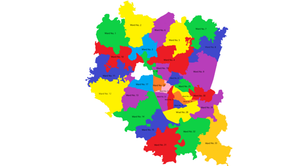
Rangpur City Corporation is divided into 33 wards and different neighbourhoods (Mahallah), which can be categorized as Urban and Suburban.
- Burirhat
- Chabbis Hazari
- Panadardighi
- Uttam
- Hazirhat
- CO Bazar
- Dhap
- Kellabond
- Radhaballov
- Shimulbag-Sagarpara
- Keranipara
- Munshipara
- Lalkuthi lane
- Khalifapara
- Jummapara
- Jahaj Company
- Nababgonj
- Betpotti-Taltola
- Kotkipara
- Parjantan Para
- Modern
- Ashratpur
- Alamnagar
- Robertsonganj
- Darshana
- Lalbagh
- Khamarpara
- Islampur
- Pirjabad
- Parbatipur
- Mahiganj
- Tajhat
- Ganeshpur
- Babukha
- DC More
- Adarshapara
Transport[]
Road[]
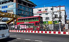
Rangpur is well connected by highways to Chittagong and Dhaka, as well as other parts of Rangpur. It takes about 6 to 7 hours by road to reach the capital Dhaka by National Highway 5. Bus services to other major districts are also available from Rangpur. Highway links to India have been established through the Asian Highway 2. Rangpur also has a BRTC Double Decker bus service,[24] which connects the suburbs of the city to city center.
Railway[]

The Rangpur Railway Station is the main railway station providing trains on national routes operated by the state-run Bangladesh Railway. The Rangpur Express[25] is a Bangladeshi Intercity train which runs between Rangpur and Dhaka. Other trains running between Rangpur and Dhaka are, Kurigram Express and Lalmoni Express.
Air[]
The city of Rangpur is served by Saidpur Airport, located at the north of the city. Saidpur airport is a domestic airport. Saidpur Airport is connected through several private airlines such as Novoair, US-Bangla Airlines, Regent Airways & Biman Bangladesh Airlines a government airline with Capital city of Bangladesh Dhaka. A massive renovation work is going on at Saidpur Airport ahead of its planning to become the new International Airport for Northern Bangladesh region.
Places of Interest[]
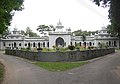
- Tajhat Palace
- Rangpur Zoo
- Chikli vata Lake
- Collectorate Surovi Park
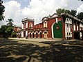
- Rangpur Town Hall
- Shrine of Maulana Karamat Ali jaunpuri RA.
- Carmichael College
Vinnojagat Amusement Park

Entrance of Rangpur Zoo
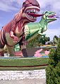
Dinosaur statue at Vinnojagat Amusement Park

Chikli Vata Lake


Dialect[]
Many Rangpur natives speak in the Rangpuri language.[citation needed] Rangpuri is an Indic language spoken by half a million Rajbongshi people in Bangladesh and five million in India, where they are known as Rajbanshi. Many are bilingual in either Bengali or Assamese. The main dialects are Western Rajbangsi, Central Rajbangsi, Eastern Rajbangsi and Hill Rajbangsi (also known as Koch language). The vast majority of Rangpur's inhabitants, however, speak Bengali and are Bengali, Rajbangsi is limited to the Rajbangsi people, which itself is in a dialect continuum with Bengali and is largely intelligible.
Sports[]

The most popular sport in Rangpur is cricket, although football is also popular. There is a 10,000-capacity Rangpur Stadium is used for football and other sports. Another local stadium is Cricket Garden,[26] which is mainly used for cricket. There are also a few sports training academies in the city. In domestic Twenty20 cricket, Rangpur has a Bangladesh Premier League franchise known as Rangpur Riders. In December 2012, bought the Rangpur franchise for $1.01 m. Notable players from Rangpur who have played for the national team include Nasir Hossain,[27] Suhrawadi Shuvo.[28]
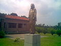
Notable people[]
Gallary[]

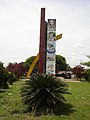
Shapla Chottor.
Zilla Porishod Building.

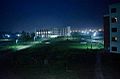
Jahaj Company area (downtown Rangpur) at night
Parjatan Motel.

Terminal Mosque (Masjid).
Rangpur Modern.
Begum Rokeya Memorial Centre.

Jadu Nibash - an ancient house

Ekattorer Boddho Bhumi - Memorial of Town Hall Massacre during 1971
Begum Rokeya University at night

Tajhat Palace


References[]
- ^ নতুন মেয়র বললেন রংপুর বদলে যাবে | কালের কণ্ঠ. Kaler Kantho (in Bengali).
- ^ "ZIP Code database of Bangladesh, Rangpur, Rangpur, Rangpur Sadar". Geopostcodes.com. Retrieved 11 June 2013.
- ^ Jump up to: a b "Journey to Rangpur City Corporation". Archived from the original on 17 June 2015. Retrieved 17 June 2015.
- ^ "Rangpur". britannica. Archived from the original on 17 June 2015. Retrieved 17 June 2015.
- ^ "Shataranji Earns GI recognition". The Daily Star. 18 June 2021. Retrieved 18 June 2021.
- ^ "রংপুর জেলা". রংপুর জেলার পটভূমি. Retrieved 16 June 2021.
- ^ "রংপুর জেলা". রংপুর জেলার ঐতিহ্য. Retrieved 16 June 2021.
- ^ Akhter, Nasrin (2012). "Sarkar". In Islam, Sirajul; Miah, Sajahan; Khanam, Mahfuza; Ahmed, Sabbir (eds.). Banglapedia: the National Encyclopedia of Bangladesh (Online ed.). Dhaka, Bangladesh: Banglapedia Trust, Asiatic Society of Bangladesh. ISBN 984-32-0576-6. OCLC 52727562. Retrieved 16 September 2021.
- ^ "Devi Chaudhurani--Bengal's very own Bandit Queen". Get Bengal. Retrieved 16 June 2021.
- ^ "রংপুর জেলা". http. Retrieved 16 June 2021.
- ^ হক, আরিফুল. "ঘাঘট সেদিন রক্তে লাল হয়েছিল". Prothomalo (in Bengali). Retrieved 16 June 2021.
- ^ "Liberation war began decisively on March 28 in Rangpur". Dhaka Tribune. 13 March 2021. Retrieved 16 June 2021.
- ^ "Rangpur turns city corporation". The Daily Star. 2 July 2012. Retrieved 16 June 2021.
- ^ https://www.risingbd.com. "Rangpur Metropolitan Police launches Sept 16". Risingbd Online Bangla News Portal. Retrieved 16 June 2021.
- ^ "Worldwide Elevation Finder". elevation.maplogs.com. Retrieved 1 June 2021.
- ^ "Rangpur climate: Average Temperature, weather by month, Rangpur weather averages - Climate-Data.org". en.climate-data.org. Retrieved 1 June 2021.
- ^ "Climate of Bangladesh" (PDF). Bangladesh Meteorological Department. pp. 19–23. Archived from the original (PDF) on 24 December 2018. Retrieved 24 December 2018.
- ^ "Normal Monthly Rainy Day" (PDF). Bangladesh Meteorological Department. Archived from the original on 9 July 2017. Retrieved 24 December 2018.
- ^ "Normal Monthly Humidity" (PDF). Bangladesh Meteorological Department. Archived from the original on 24 December 2018. Retrieved 24 December 2018.
- ^ "Tobacco cultivation still on in Rangpur region". Dhaka Tribune. 2 January 2014. Retrieved 1 June 2021.
- ^ "Rangpur, Bangladesh population". populationstat.com.
- ^ "রংপুর সিটি কর্পোরেশন".
- ^ Muhammad Maniruzzaman (2012). "Carmichael College, Rangpur". In Sirajul Islam; Ahmed A. Jamal (eds.). Banglapedia: National Encyclopedia of Bangladesh (Second ed.). Asiatic Society of Bangladesh. Archived from the original on 17 June 2015. Retrieved 17 June 2015.
- ^ Express, The Financial. "BRTC launches city bus service in Rangpur". The Financial Express. Retrieved 11 June 2021.
- ^ "Dhaka-Rangpur railway inaugurated". The Daily Star. 22 August 2011. Retrieved 11 June 2021.
- ^ Cricket Garden, Rangpur, CricketArchive.com Retrieved on 29 July 2010.
- ^ Players and Officials – Nasir Hossain Cricinfo.
- ^ Players and Officials – Suhrawadi Shuvo Cricinfo.
External links[]
| Wikimedia Commons has media related to Rangpur. |
| Wikisource has the text of the 1911 Encyclopædia Britannica article "Rangpur". |
- Rangpur City Corporation
- Rangpur oriented website
- Abdus Sattar (2012). "Rangpur District". In Sirajul Islam; Ahmed A. Jamal (eds.). Banglapedia: National Encyclopedia of Bangladesh (Second ed.). Asiatic Society of Bangladesh. Retrieved 13 May 2016.
| Rank | Name | Division | Pop. | Rank | Name | Division | Pop. | ||
|---|---|---|---|---|---|---|---|---|---|
 Dhaka  Chittagong |
1 | Dhaka | Dhaka | 8,906,039 | 11 | Savar | Dhaka | 296,851 |  Khulna  Sylhet |
| 2 | Chittagong | Chittagong | 2,592,439 | 12 | Comilla | Chittagong | 296,010 | ||
| 3 | Khulna | Khulna | 664,728 | 13 | Narayanganj | Dhaka | 286,330 | ||
| 4 | Sylhet | Sylhet | 531,663 | 14 | Siddhirganj | Dhaka | 256,760 | ||
| 5 | Rajshahi | Rajshahi | 451,425 | 15 | Jessore | Khulna | 237,478 | ||
| 6 | Tongi | Dhaka | 406,420 | 16 | Cox's Bazar | Chittagong | 223,522 | ||
| 7 | Bogra | Rajshahi | 400,983 | 17 | Gazipur | Dhaka | 213,061 | ||
| 8 | Mymensingh | Mymensingh | 389,918 | 18 | Brahmanbaria | Chittagong | 193,814 | ||
| 9 | Barisal | Barisal | 339,308 | 19 | Dinajpur | Rangpur | 191,329 | ||
| 10 | Rangpur | Rangpur | 307,053 | 20 | Narsingdi | Dhaka | 185,128 | ||
- ^ "National Volume-3: Urban Area Report" (PDF), Population and Housing Census 2011, Bangladesh Bureau of Statistics, pp. 24–25, August 2014
- Rangpur, Bangladesh
- Populated places in Rangpur Division