Nasketucket River
| Nasketucket River Naskatucket River Nasketuckett River | |
|---|---|
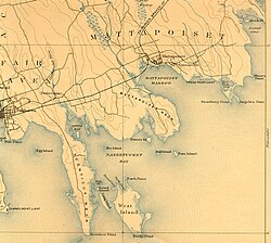 Nasketucket River and vicinity, 1893. | |
| Location | |
| Country | United States |
| State | Massachusetts |
| Region | Fairhaven |
| Physical characteristics | |
| Source | |
| • coordinates | 41°39′15″N 70°53′12″W / 41.65417°N 70.88667°W |
| Mouth | |
• location | Little Bay |
• coordinates | 41°37′55″N 70°51′58″W / 41.63194°N 70.86611°WCoordinates: 41°37′55″N 70°51′58″W / 41.63194°N 70.86611°W |
• elevation | 0 ft (0 m) |
| Length | 3 mi (4.8 km) |

The Nasketucket River is a small river (stream) arising in Fairhaven, Massachusetts, and emptying about 3 miles downstream into Little Bay, a branch of on Buzzards Bay.[1][2]
References[]
- ^ USGS quadrangle map
- ^ "Nasketucket River". Geographic Names Information System. United States Geological Survey. Retrieved 2014-09-13.
This Bristol County, Massachusetts geography–related article is a stub. You can help Wikipedia by . |
Categories:
- Fairhaven, Massachusetts
- Rivers of Bristol County, Massachusetts
- Rivers of Massachusetts
- Bristol County, Massachusetts geography stubs
- Massachusetts river stubs