Cape Cod Bay


Cape Cod Bay is a large bay of the Atlantic Ocean adjacent to the U.S. state of Massachusetts. Measuring 604 square miles (1,560 km2) below a line drawn from Brant Rock in Marshfield to Race Point in Provincetown, Massachusetts, it is enclosed by Cape Cod to the south and east, and Plymouth County, Massachusetts, to the west. To the north of Cape Cod Bay lie Massachusetts Bay and the Atlantic Ocean.[1] Cape Cod Bay is the southernmost extremity of the Gulf of Maine. Cape Cod Bay is one of the bays adjacent to Massachusetts that give it the name Bay State. The others are Narragansett Bay, Buzzards Bay, and Massachusetts Bay.
History[]
In 1524, Italian navigator Giovanni da Verrazzano was the first European to discover Cape Cod Bay, his claim proved by a map of 1529 which clearly outlined Cape Cod.[2] In 1620, the Pilgrims first sheltered in Provincetown Harbor where they signed the Mayflower Compact, the first democratic document signed in the New World.[1]
Geology[]
Most of Cape Cod is composed of glacially derived rocks, sands, and gravels. The last glacial period ended about 12,000 years ago. During the end of the last glaciation, Cape Cod Bay was probably a large freshwater lake with drainages across Cape Cod in places like Bass River and Orleans Harbor. The Provincetown Spit, i.e., the land north of High Head in North Truro, was formed by marine deposits over the last 5,000-8,000 years. These deposits created Provincetown Harbor, a large, bowl-shaped section of Cape Cod Bay. Generally, currents in the Bay move in a counter-clockwise fashion, moving south from Boston, to Plymouth then east and then north to Provincetown.
Since 1914, Cape Cod Bay has been connected to Buzzards Bay by the Cape Cod Canal, which divides the upper cape towns of Bourne and Sandwich.
Ecology[]
The sea life of Cape Cod Bay is quite varied and healthy. Fish that call the bay home include Bluefin Tuna, Striped Bass, Bluefish, Flounder, and Atlantic Mackerel. Sea mammals also live in Cape Cod Bay (seals, dolphins and whales).
The Pilgrims shot at a whale unsuccessfully while they were anchored in Provincetown Harbor in 1620.
Fishing[]
Cape Cod Bay is a world class fishing destination for many anglers. Popular fishing methods used to fish Cape Cod bay include trolling, live bait fishing, light tackle fishing, and fly fishing. Fisherman typically fish off the coast of the South Shore (Massachusetts) and inner cape for fish such as Blue Fish, Cod, Flounder, Striped Bass, Bonito, Tuna, Mackerel, Pollock, Haddock, and even Sharks.[3]
Fishing season typically takes place between May and October. Although plenty of fisherman prefer to fish from shore rather than a boat, Massachusetts requires a Recreational Saltwater Fishing Permit for anyone 16 years of age or older.[4]
Many coastal towns have fishing piers, and boat charters that provide daily trips into Cape Cod Bay to catch fish. The most popular bait used is sea clams, and live mackerel.
Brewster Flats[]

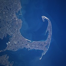
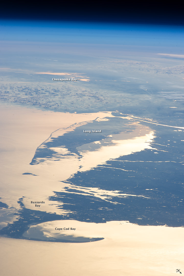
The Brewster Flats (41°46′46.0″N 70°3′39.7″W / 41.779444°N 70.061028°W) are tidal flats on Cape Cod Bay,[5] particularly near the town of Brewster, and are a unique environment. They are the widest expanse of tidal flats in North America, rivaled in the western hemisphere only by a similar expanse in Brazil. Note: this picture taken from space appears inverted left to right, thus on the East Coast of the U.S. Chesapeake Bay should show to the left of the coastline as viewed from the North, as it is in this case. Not the right. I do not know how to correct this. The flats extend all the way to North Eastham. You can see oyster farming at Skaket Beach in Orleans.
 WikiMiniAtlas
View[]
See also[]
- Cape Cod
References[]
- ^ Jump up to: a b Theresa Mitchell Barbo (2008). Cape Cod Bay A History of Salt and Sea. The History Press. ISBN 978-1-59629-502-5.
- ^ History of Barnstable County, Massachusetts. p. 950. Retrieved 2010-08-21.
- ^ . "Deep Sea Fishing." Captain John. N.p.. Web. 6 Dec 2012. <http://captjohn.com/DeepSeaFishing/index.htm> Archived November 27, 2012, at the Wayback Machine.
- ^ "Massachusetts Recreational Saltwater Fishing Permit." Massachusetts Saltwater. N.p., n.d. Web. 6 Dec 2012. <http://www.eregulations.com/massachusetts/fishing/saltwater/massachusetts-recreational-saltwater-fishing-permit/ Archived 2012-12-05 at the Wayback Machine.
- ^ Dattilo, Emily (27 August 2020). "Explore nature in Brewster and Harwich". Cape Cod Times. Retrieved 9 September 2020.
Coordinates: 41°54′N 70°17′W / 41.900°N 70.283°W
| show Authority control |
|---|
- Bodies of water of Barnstable County, Massachusetts
- Bays of Massachusetts
- Massachusetts natural resources
- Bays of Plymouth County, Massachusetts