National Park, New Jersey
National Park, New Jersey | |
|---|---|
| Borough of National Park | |
 | |
| Motto(s): Home to the Red Bank Battlefield | |
 Map of National Park highlighted within Gloucester County. Inset: Location of Gloucester County in New Jersey. | |
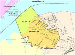 Census Bureau map of National Park, New Jersey | |
 National Park Location in Gloucester County | |
| Coordinates: 39°52′02″N 75°11′08″W / 39.867297°N 75.185621°WCoordinates: 39°52′02″N 75°11′08″W / 39.867297°N 75.185621°W[1][2] | |
| Country | |
| State | |
| County | |
| Incorporated | April 15, 1902 |
| Government | |
| • Type | Borough |
| • Body | Borough Council |
| • Mayor | Mark Cooper (D, term ends December 31, 2023)[3][4] |
| • Administrator / Municipal clerk | Joy Gunn[5] |
| Area | |
| • Total | 1.44 sq mi (3.73 km2) |
| • Land | 1.01 sq mi (2.61 km2) |
| • Water | 0.43 sq mi (1.12 km2) 30.14% |
| Area rank | 457th of 565 in state 20th of 24 in county[1] |
| Elevation | 13 ft (4 m) |
| Population | |
| • Total | 3,036 |
| • Estimate (2019)[11] | 2,943 |
| • Rank | 452nd of 566 in state 21st of 24 in county[12] |
| • Density | 3,023.2/sq mi (1,167.3/km2) |
| • Density rank | 215th of 566 in state 6th of 24 in county[12] |
| Time zone | UTC−05:00 (Eastern (EST)) |
| • Summer (DST) | UTC−04:00 (Eastern (EDT)) |
| ZIP Code | |
| Area code(s) | 856[15] |
| FIPS code | 3401549680[1][16][17] |
| GNIS feature ID | 0885314[1][18] |
| Website | www |


National Park is a borough in Gloucester County, New Jersey, United States. As of the 2010 United States Census, the borough's population was 3,036,[8][9][10] reflecting a decline of 169 (−5.3%) from the 3,205 counted in the 2000 Census, which had in turn declined by 208 (−6.1%) from the 3,413 counted in the 1990 Census.[19] Despite its name, National Park is neither a national park nor associated with one.
History[]

In 1777, during the American Revolutionary War, the Continental Army under command of George Washington constructed two forts on the Delaware River to block the approach to Philadelphia: Fort Mifflin on the Pennsylvania side and Fort Mercer on the New Jersey side in what is now National Park. The fort was named in honor of Brigadier General Hugh Mercer who had died earlier that year at the Battle of Princeton. A park, monument, and museum commemorate the fort on its original site.
On October 22 of that year, in what is known as the Battle of Red Bank, an attack by 900 Hessian troops, serving under British Major General William Howe, who then occupied Philadelphia, was repelled, with heavy losses on the Hessian side (including the death of their commander, Colonel Carl Emil Kurt von Donop) by the 600 Continental defenders under Colonel Christopher Greene. After the loss of Fort Mifflin, Fort Mercer was abandoned without a fight when Lord Charles Cornwallis landed 2,000 British troops nearby on November 18.[20][21]
Beginning in 1895, the area was commercially developed as a religious retreat for members of the Methodist Episcopal Church and called National Park on the Delaware. The founder, the Rev. James E. Lake, also created Ocean City, New Jersey.[22]
National Park was formed as a borough by an act of the New Jersey Legislature on April 15, 1902, from portions of West Deptford Township.[23] The town name probably originated in reference to the county park at Red Bank Battlefield.[24]
Geography[]
According to the United States Census Bureau, the borough had a total area of 1.44 square miles (3.73 km2), including 1.01 square miles (2.61 km2) of land and 0.43 square miles (1.12 km2) of water (30.14%).[1][2]
The borough borders West Deptford Township and the Delaware River. The Delaware River shore faces the southern end of Philadelphia, approximately across from the mouth of the Schuylkill River and the site of Fort Mifflin.[25][26]
Demographics[]
| Historical population | |||
|---|---|---|---|
| Census | Pop. | %± | |
| 1910 | 325 | — | |
| 1920 | 1,000 | 207.7% | |
| 1930 | 1,828 | 82.8% | |
| 1940 | 1,977 | 8.2% | |
| 1950 | 2,419 | 22.4% | |
| 1960 | 3,380 | 39.7% | |
| 1970 | 3,730 | 10.4% | |
| 1980 | 3,552 | −4.8% | |
| 1990 | 3,413 | −3.9% | |
| 2000 | 3,205 | −6.1% | |
| 2010 | 3,036 | −5.3% | |
| 2019 (est.) | 2,943 | [11][27] | −3.1% |
| Population sources: 1910-2000[28] 1910-1920[29] 1910[30] 1910-1930[31] 1930-1990[32] 2000[33][34] 2010[8][9][10] | |||
Census 2010[]
The 2010 United States census counted 3,036 people, 1,092 households, and 816 families in the borough. The population density was 3,023.2 per square mile (1,167.3/km2). There were 1,153 housing units at an average density of 1,148.1 per square mile (443.3/km2). The racial makeup was 96.28% (2,923) White, 1.35% (41) Black or African American, 0.16% (5) Native American, 0.59% (18) Asian, 0.00% (0) Pacific Islander, 0.13% (4) from other races, and 1.48% (45) from two or more races. Hispanic or Latino of any race were 2.04% (62) of the population.[8]
Of the 1,092 households, 30.1% had children under the age of 18; 52.5% were married couples living together; 15.4% had a female householder with no husband present and 25.3% were non-families. Of all households, 20.2% were made up of individuals and 7.9% had someone living alone who was 65 years of age or older. The average household size was 2.77 and the average family size was 3.18.[8]
23.1% of the population were under the age of 18, 9.7% from 18 to 24, 25.5% from 25 to 44, 30.3% from 45 to 64, and 11.5% who were 65 years of age or older. The median age was 39.2 years. For every 100 females, the population had 94.7 males. For every 100 females ages 18 and older there were 93.2 males.[8]
The Census Bureau's 2006-2010 American Community Survey showed that (in 2010 inflation-adjusted dollars) median household income was $65,852 (with a margin of error of +/- $5,987) and the median family income was $70,341 (+/- $8,049). Males had a median income of $51,886 (+/- $2,493) versus $32,788 (+/- $5,594) for females. The per capita income for the borough was $26,699 (+/- $2,574). About 4.1% of families and 4.3% of the population were below the poverty line, including 6.8% of those under age 18 and 6.7% of those age 65 or over.[35]
Census 2000[]
As of the 2000 United States Census[16] there were 3,205 people, 1,111 households, and 865 families residing in the borough. The population density was 3,219.0 people per square mile (1,237.5/km2). There were 1,165 housing units at an average density of 1,170.1 per square mile (449.8/km2). The racial makeup of the borough was 98.35% White, 0.09% Black, 0.25% Native American, 0.25% Asian, 0.03% Pacific Islander, 0.53% from other races, and 0.50% from two or more races. Hispanic or Latino of any race were 1.44% of the population.[33][34]
There were 1,111 households, out of which 37.3% had children under the age of 18 living with them, 58.2% were married couples living together, 14.0% had a female householder with no husband present, and 22.1% were non-families. 18.6% of all households were made up of individuals, and 8.6% had someone living alone who was 65 years of age or older. The average household size was 2.86 and the average family size was 3.24.[33][34]
In the borough the population was spread out, with 26.4% under the age of 18, 9.3% from 18 to 24, 29.7% from 25 to 44, 22.2% from 45 to 64, and 12.5% who were 65 years of age or older. The median age was 37 years. For every 100 females, there were 99.2 males. For every 100 females age 18 and over, there were 93.8 males.[33][34]
The median income for a household in the borough was $48,534, and the median income for a family was $51,535. Males had a median income of $35,102 versus $27,398 for females. The per capita income for the borough was $18,048. About 6.5% of families and 7.6% of the population were below the poverty line, including 6.7% of those under age 18 and 7.9% of those age 65 or over.[33][34]
Government[]
Local government[]
National Park is governed under the Borough form of New Jersey municipal government, which is used in 218 municipalities (of the 565) statewide, making it the most common form of government in New Jersey.[36] The governing body is comprised of the Mayor and the Borough Council, with all positions elected at-large on a partisan basis as part of the November general election. The Mayor is elected directly by the voters to a four-year term of office. The Borough Council is comprised of six members elected to serve three-year terms on a staggered basis, with two seats coming up for election each year in a three-year cycle.[6] The Borough form of government used by National Park is a "weak mayor / strong council" government in which council members act as the legislative body with the mayor presiding at meetings and voting only in the event of a tie. The mayor can veto ordinances subject to an override by a two-thirds majority vote of the council. The mayor makes committee and liaison assignments for council members, and most appointments are made by the mayor with the advice and consent of the council.[37][38]
As of 2020, the Mayor of National Park is Democrat Mark Cooper, whose term of office ends December 31, 2023. Members of the Borough Council are Dennis R. Burke (D, 2022), James J. Butler (D, 2021), Aimee Hart (D, 2022; appointed to serve an unexpired term), Larry J. Prelle Sr. (D, 2020) and Joseph N. Smashey Sr. (D, 2020) and Ronald D. Sparks Jr. (D, 2021).[3][39][40][41][42][43]
Aimee Hart was appointed to fill the seat expiring in December 2022 that had been held by Joy Gunn.
Joy Hibbs Gunn was selected by the Borough Council in August 2014 from three names nominated by the municipal Democratic committee to fill the vacant seat of Dennis Mehaffey, who resigned in the previous month due to conflicts with his work schedule.[44] in the November 2014 general election, Hibbs was elected to serve the balance of the term though December 2016.[45]
Federal, state and county representation[]
National Park is located in the 1st Congressional District[46] and is part of New Jersey's 3rd state legislative district.[9][47][48]
For the 117th United States Congress, New Jersey's First Congressional District is represented by Donald Norcross (D, Camden).[49][50] New Jersey is represented in the United States Senate by Democrats Cory Booker (Newark, term ends 2027)[51] and Bob Menendez (Harrison, term ends 2025).[52][53]
For the 2018–2019 session (Senate, General Assembly), the 3rd Legislative District of the New Jersey Legislature is represented in the State Senate by Stephen M. Sweeney (D, West Deptford Township) and in the General Assembly by John J. Burzichelli (D, Paulsboro) and Adam Taliaferro (D, Woolwich Township).[54][55]
Gloucester County is governed by a board of county commissioners, whose seven members are elected at-large to three-year terms of office on a staggered basis in partisan elections, with two or three seats coming up for election each year. At a reorganization meeting held each January, the Board selects a Director and a Deputy Director from among its members. As of 2021, Gloucester County's Commissioners are Director Robert M. Damminger (D, West Deptford Township; 2021),[56] Deputy Director Frank J. DiMarco (D, Deptford Township; 2022),[57] Lyman J. Barnes (D, Logan Township; 2023),[58] Daniel Christy (D, Washington Township; 2022),[59] Jim Jefferson (D, Woodbury; 2023),[60] Jim Lavender (D, Woolwich Township; 2021),[61] and Heather Simmons (D, Glassboro; 2023).[62][63]
Constitutional officers elected countywide are: County Clerk James N. Hogan (D, Franklinville in Franklin Township; 5-year term ends 2022),[64][65][66] Sheriff Carmel Morina (D, Greenwich Township; 3-year term ends 2021)[67][68][69] and Surrogate Giuseppe "Joe" Chila (D, Woolwich Township; 5-year term ends 2022).[70][71][72][66][73][69]
Politics[]
As of March 23, 2011, there were a total of 2,045 registered voters in National Park, of which 1,021 (49.9%) were registered as Democrats, 213 (10.4%) were registered as Republicans and 811 (39.7%) were registered as Unaffiliated. There were no voters registered to other parties.[74]
In the 2012 presidential election, Democrat Barack Obama received 63.8% of the vote (819 cast), ahead of Republican Mitt Romney with 34.4% (442 votes), and other candidates with 1.8% (23 votes), among the 1,301 ballots cast by the borough's 2,064 registered voters (17 ballots were spoiled), for a turnout of 63.0%.[75][76] In the 2008 presidential election, Democrat Barack Obama received 59.5% of the vote (892 cast), ahead of Republican John McCain with 37.3% (560 votes) and other candidates with 1.7% (26 votes), among the 1,500 ballots cast by the borough's 2,164 registered voters, for a turnout of 69.3%.[77] In the 2004 presidential election, Democrat John Kerry received 60.9% of the vote (868 ballots cast), outpolling Republican George W. Bush with 37.6% (536 votes) and other candidates with 0.7% (15 votes), among the 1,426 ballots cast by the borough's 2,069 registered voters, for a turnout percentage of 68.9.[78]
In the 2013 gubernatorial election, Republican Chris Christie received 64.6% of the vote (469 cast), ahead of Democrat Barbara Buono with 32.0% (232 votes), and other candidates with 3.4% (25 votes), among the 746 ballots cast by the borough's 2,041 registered voters (20 ballots were spoiled), for a turnout of 36.6%.[79][80] In the 2009 gubernatorial election, Democrat Jon Corzine received 46.2% of the vote (408 ballots cast), ahead of Republican Chris Christie with 40.2% (355 votes), Independent Chris Daggett with 10.2% (90 votes) and other candidates with 0.8% (7 votes), among the 883 ballots cast by the borough's 2,095 registered voters, yielding a 42.1% turnout.[81]
Education[]
The National Park School District serves public school students in pre-kindergarten through sixth grade at National Park Elementary School.[82] As of the 2018–19 school year, the district, comprised of one school, had an enrollment of 274 students and 24.8 classroom teachers (on an FTE basis), for a student–teacher ratio of 11.0:1.[83]
Students in public school for seventh through twelfth grades attend Gateway Regional High School, which serves students from the boroughs of National Park, Wenonah, Westville and Woodbury Heights as part of the Gateway Regional High School District.[84][85] As of the 2018–19 school year, the high school had an enrollment of 879 students and 81.5 classroom teachers (on an FTE basis), for a student–teacher ratio of 10.8:1.[86]
Students are also eligible to attend Gloucester County Institute of Technology, a four-year high school in Deptford Township that provides technical and vocational education. Because GCIT is a public school, its students do not pay tuition.[87]
The Roman Catholic Diocese of Camden operated St. Matthews School, which had campuses in National Park and Verga.[88] In 2007 it was consolidated into Holy Trinity Regional School,[89] in Deptford. In 2017 was moved to the former St. Patrick's Building in Woodbury due to the superior condition of that building, according to the archdiocese.[90] It opened as Holy Angels Catholic School which still operates.[91] Additionally As of 2020 Guardian Angels Regional School (Pre-K-Grade 3 campus in Gibbstown CDP and 4-8 campus in Paulsboro) takes students from National Park.[92]
Transportation[]

Roads and highways[]
As of May 2010, the borough had a total of 15.68 miles (25.23 km) of roadways, of which 12.59 miles (20.26 km) were maintained by the municipality and 3.09 miles (4.97 km) by Gloucester County.[93]
No Interstate, U.S., state or major county highways directly serve National Park. The most significant roads are minor county routes, such as County Route 642. Interstate 295 and U.S. Route 130 pass just outside the town in neighboring West Deptford Township.
Public transportation[]
NJ Transit local bus service is available on the 455 route operating between Cherry Hill Mall and Paulsboro.[94][95]
Site of Fort Mercer[]
Notable people[]
People who were born in, residents of, or otherwise closely associated with National Park include:
- Nick Gage (born 1980), professional wrestler.[96]
- Sue Lowden (born 1952), Miss New Jersey 1973 winner who is a former Chairwoman of the Nevada Republican Party and a former state senator in Nevada.[97]
- Eleanor Vadala (born 1923), chemist, materials engineer and balloonist.[98]
References[]
- ^ Jump up to: a b c d e f 2019 Census Gazetteer Files: New Jersey Places, United States Census Bureau. Accessed July 1, 2020.
- ^ Jump up to: a b US Gazetteer files: 2010, 2000, and 1990, United States Census Bureau. Accessed September 4, 2014.
- ^ Jump up to: a b Mayor and Council, Borough of National Park. Accessed May 11, 2020.
- ^ 2020 New Jersey Mayors Directory, New Jersey Department of Community Affairs. Accessed February 1, 2020.
- ^ Municipal Clerk and Administrator, Borough of National Park. Accessed May 11, 2020.
- ^ Jump up to: a b 2012 New Jersey Legislative District Data Book, Rutgers University Edward J. Bloustein School of Planning and Public Policy, March 2013, p. 19.
- ^ U.S. Geological Survey Geographic Names Information System: Borough of National Park, Geographic Names Information System. Accessed March 8, 2013.
- ^ Jump up to: a b c d e f DP-1 - Profile of General Population and Housing Characteristics: 2010 for National Park borough, Gloucester County, New Jersey Archived 2020-02-12 at archive.today, United States Census Bureau. Accessed November 7, 2012.
- ^ Jump up to: a b c d Municipalities Sorted by 2011-2020 Legislative District, New Jersey Department of State. Accessed February 1, 2020.
- ^ Jump up to: a b c Profile of General Demographic Characteristics: 2010 for National Park borough Archived 2013-08-11 at the Wayback Machine, New Jersey Department of Labor and Workforce Development. Accessed November 7, 2012.
- ^ Jump up to: a b Annual Estimates of the Resident Population for Minor Civil Divisions in New Jersey: April 1, 2010 to July 1, 2019, United States Census Bureau. Accessed May 21, 2020.
- ^ Jump up to: a b GCT-PH1 Population, Housing Units, Area, and Density: 2010 - State -- County Subdivision from the 2010 Census Summary File 1 for New Jersey Archived 2020-02-12 at archive.today, United States Census Bureau. Accessed November 7, 2012.
- ^ Look Up a ZIP Code for National Park, NJ, United States Postal Service. Accessed November 7, 2012.
- ^ Zip Codes, State of New Jersey. Accessed August 28, 2013.
- ^ Area Code Lookup - NPA NXX for National Park, NJ, Area-Codes.com. Accessed August 28, 2013.
- ^ Jump up to: a b U.S. Census website , United States Census Bureau. Accessed September 4, 2014.
- ^ Geographic codes for New Jersey, Missouri Census Data Center. Accessed September 1, 2019.
- ^ US Board on Geographic Names, United States Geological Survey. Accessed September 4, 2014.
- ^ Table 7. Population for the Counties and Municipalities in New Jersey: 1990, 2000 and 2010, New Jersey Department of Labor and Workforce Development, February 2011. Accessed November 7, 2012.
- ^ About National Park, Borough of National Park. Accessed November 10, 2019.
- ^ Red Bank Battlefield Park, Gloucester County, New Jersey. Accessed November 10, 2019.
- ^ Shamlin, Wilford S. "National Park has green, but no park", Courier Post, July 1, 2005. Accessed November 7, 2012. "Originally named National Park on the Delaware River, National Park was incorporated on April 15, 1902. But it was several years earlier, in 1895, that the Rev. James E. Lake, who also founded Ocean City, and others incorporated The National Park Association."
- ^ Snyder, John P. The Story of New Jersey's Civil Boundaries: 1606-1968, Bureau of Geology and Topography; Trenton, New Jersey; 1969. p. 140. Accessed October 23, 2012.
- ^ Hutchinson, Viola L. The Origin of New Jersey Place Names, New Jersey Public Library Commission, May 1945. Accessed September 9, 2015.
- ^ Municipalities within Gloucester County, NJ, Delaware Valley Regional Planning Commission. Accessed November 7, 2019.
- ^ New Jersey Municipal Boundaries, New Jersey Department of Transportation. Accessed November 7, 2019.
- ^ Census Estimates for New Jersey April 1, 2010 to July 1, 2019, United States Census Bureau. Accessed May 21, 2020.
- ^ Barnett, Bob. "Population Data for Gloucester County Municipalities, 1800 - 2000, WestJersey.org, January 6, 2011. Accessed November 7, 2012.
- ^ Compendium of censuses 1726-1905: together with the tabulated returns of 1905, New Jersey Department of State, 1906. Accessed August 13, 2013.
- ^ Thirteenth Census of the United States, 1910: Population by Counties and Minor Civil Divisions, 1910, 1900, 1890, United States Census Bureau, p. 336. Accessed November 7, 2012.
- ^ Fifteenth Census of the United States : 1930 - Population Volume I, United States Census Bureau, p. 716. Accessed November 7, 2012.
- ^ Table 6. New Jersey Resident Population by Municipality: 1930 - 1990, New Jersey Department of Labor and Workforce Development. Accessed June 28, 2015.
- ^ Jump up to: a b c d e Census 2000 Profiles of Demographic / Social / Economic / Housing Characteristics for National Park borough, New Jersey Archived 2015-02-01 at the Wayback Machine, United States Census Bureau. Accessed November 7, 2012.
- ^ Jump up to: a b c d e DP-1: Profile of General Demographic Characteristics: 2000 - Census 2000 Summary File 1 (SF 1) 100-Percent Data for National Park borough, Gloucester County, New Jersey Archived 2020-02-12 at archive.today, United States Census Bureau. Accessed November 7, 2012.
- ^ DP03: Selected Economic Characteristics from the 2006-2010 American Community Survey 5-Year Estimates for National Park borough, Gloucester County, New Jersey Archived 2020-02-12 at archive.today, United States Census Bureau. Accessed November 7, 2012.
- ^ Inventory of Municipal Forms of Government in New Jersey, Rutgers University Center for Government Studies, July 1, 2011. Accessed November 18, 2019.
- ^ Cerra, Michael F. "Forms of Government: Everything You've Always Wanted to Know, But Were Afraid to Ask" Archived 2014-09-24 at the Wayback Machine, New Jersey State League of Municipalities. Accessed November 30, 2014.
- ^ "Forms of Municipal Government in New Jersey", p. 6. Rutgers University Center for Government Studies. Accessed June 3, 2015.
- ^ 2019 Municipal User Friendly Budget for National Park Borough, Gloucester County, New Jersey Department of Community Affairs. Accessed November 10, 2019.
- ^ Gloucester County 2020 Official Directory, Gloucester County, New Jersey. Accessed May 11, 2020.
- ^ General Election November 5, 2019 Summary Report Unofficial Results, Gloucester County, New Jersey Clerk, November 12, 2019. Accessed January 1, 2020.
- ^ General Election November 6, 2018 Summary Report Unofficial Results, Gloucester County, New Jersey Clerk, November 12, 2018. Accessed January 1, 2019.
- ^ General Election November 7, 2017 Summary Report Unofficial Results, Gloucester County, New Jersey Clerk, November 14, 2017. Accessed January 1, 2018.
- ^ Laday, Jason. "National Park swears in new council member following resignation", South Jersey Times, August 16, 2014. Accessed November 20, 2014. "Mayor Mark Cooper on Wednesday swore in newly-appointed Councilwoman Joy Hibbs, replacing Dennis Mehaffey, who has resigned from the borough council."
- ^ 2014 General Election Unofficial Results, Gloucester County, New Jersey Clerk, updated November 13, 2014. Accessed July 5, 2016.
- ^ Plan Components Report, New Jersey Redistricting Commission, December 23, 2011. Accessed February 1, 2020.
- ^ 2019 New Jersey Citizen's Guide to Government, New Jersey League of Women Voters. Accessed October 30, 2019.
- ^ Districts by Number for 2011-2020, New Jersey Legislature. Accessed January 6, 2013.
- ^ Directory of Representatives: New Jersey, United States House of Representatives. Accessed January 3, 2019.
- ^ Full Biography, Congressman Donald Norcross. Accessed January 3, 2019. "Donald and his wife Andrea live in Camden City and are the proud parents of three grown children and grandparents of two."
- ^ [1], United States Senate. Accessed April 30, 2021. "He now owns a home and lives in Newark's Central Ward community."
- ^ Biography of Bob Menendez, United States Senate, January 26, 2015. "Menendez, who started his political career in Union City, moved in September from Paramus to one of Harrison's new apartment buildings near the town's PATH station.."
- ^ [2]. United States Senate. Accessed April 30, 2021. "Booker, Cory A. - (D - NJ) Class II; Menendez, Robert - (D - NJ) Class I"
- ^ Legislative Roster 2018-2019 Session, New Jersey Legislature. Accessed January 21, 2018.
- ^ District 3 Legislators, New Jersey Legislature. Accessed January 22, 2018.
- ^ Robert M. Damminger, Gloucester County, New Jersey. Accessed March 20, 2021.
- ^ Frank J. DiMarco, Gloucester County, New Jersey. Accessed March 20, 2021.
- ^ Lyman Barnes, Gloucester County, New Jersey. Accessed March 20, 2021.
- ^ Daniel Christy, Gloucester County, New Jersey. Accessed March 20, 2021.
- ^ Jim Jefferson, Gloucester County, New Jersey. Accessed March 20, 2021.
- ^ Jim Lavender, Gloucester County, New Jersey. Accessed March 20, 2021.
- ^ Heather Simmons, Gloucester County, New Jersey. Accessed March 20, 2021.
- ^ County Commissioners, Gloucester County, New Jersey. Accessed March 20, 2021.
- ^ James N. Hogan, Gloucester County. Accessed March 20, 2021.
- ^ Members List: Clerks, Constitutional Officers Association of New Jersey. Accessed March 20, 2021.
- ^ Jump up to: a b 2017 Gloucester County Election Results, Office of the Gloucester County Clerk. Accessed February 11, 2020.
- ^ Sheriff Carmel M. Morina, Gloucester County. Accessed March 20, 2021.
- ^ Members List: Sheriffs, Constitutional Officers Association of New Jersey. Accessed March 20, 2021.
- ^ Jump up to: a b 2018 Gloucester County Election Results, Office of the Gloucester County Clerk. Accessed February 11, 2020.
- ^ Surrogate Giuseppe Chila, Gloucester County. Accessed March 20, 2021.
- ^ Members List: Surrogates, Constitutional Officers Association of New Jersey. Accessed March 20, 2021.
- ^ Row Officers, Gloucester County, New Jersey. Accessed March 20, 2021.
- ^ Helene Reed Dies, New Jersey Globe, April 28, 2018. Accessed February 11, 2020.
- ^ Voter Registration Summary - Gloucester, New Jersey Department of State Division of Elections, March 23, 2011. Accessed November 7, 2012.
- ^ "Presidential General Election Results - November 6, 2012 - Gloucester County" (PDF). New Jersey Department of Elections. March 15, 2013. Retrieved December 24, 2014.
- ^ "Number of Registered Voters and Ballots Cast - November 6, 2012 - General Election Results - Gloucester County" (PDF). New Jersey Department of Elections. March 15, 2013. Retrieved December 24, 2014.
- ^ 2008 Presidential General Election Results: Gloucester County, New Jersey Department of State Division of Elections, December 23, 2008. Accessed November 7, 2012.
- ^ 2004 Presidential Election: Gloucester County, New Jersey Department of State Division of Elections, December 13, 2004. Accessed November 7, 2012.
- ^ "Governor - Gloucester County" (PDF). New Jersey Department of Elections. January 29, 2014. Retrieved December 24, 2014.
- ^ "Number of Registered Voters and Ballots Cast - November 5, 2013 - General Election Results - Gloucester County" (PDF). New Jersey Department of Elections. January 29, 2014. Retrieved December 24, 2014.
- ^ 2009 Governor: Gloucester County Archived 2012-10-17 at the Wayback Machine, New Jersey Department of State Division of Elections, December 31, 2009. Accessed November 7, 2012.
- ^ About the School, National Park School District. Accessed May 11, 2020. "National Park School is a vibrant educational environment where teachers, students, families and community members work together to promote a love of learning. Comprised of approximately 50 staff members and 275 students in Pre-Kindergarten through Sixth Grade, the school is located in National Park, a small town along the Delaware River."
- ^ District information for National Park Boro School District, National Center for Education Statistics. Accessed April 1, 2020.
- ^ Gateway Regional High School District 2015 School Report Card Narrative, New Jersey Department of Education. Accessed June 8, 2016. "Gateway Regional High School is a one school district located in Woodbury Heights, NJ. It serves students in grades 7-12 from the municipalities of National Park, Wenonah, Westville, and Woodbury Heights."
- ^ Shryock, Bob. "Plans are in the works for Gateway's 50th anniversary", Gloucester County Times, March 22, 2012. Accessed June 8, 2016. "The 50-year milestone is based on Gateway opening in the fall of 2014 when four sending districts (Woodbury Heights, Westville, National Park and Wenonah) split from Woodbury and sent seventh, eighth and ninth graders to the new school on Egg Harbor Road in Woodbury Heights."
- ^ School data for Gateway Regional High School, National Center for Education Statistics. Accessed April 1, 2020.
- ^ Admissions, Gloucester County Institute of Technology. Accessed November 7, 2019. "There is no charge to attend. GCIT is a public school.... GCIT is the vocational-technical school for Gloucester County residents. You must live in Gloucester County to apply and attend."
- ^ "SCHOOLS IN THE DIOCESE OF CAMDEN". Roman Catholic Diocese of Camden. September 1, 2000. Retrieved September 11, 2020.
National Park/Verga St. Matthew Regional [...] 1210 Hessian Avenue, Verga, 0809
- ^ "Bishop to announce school planning decisions Nov. 29". Diocese of Camden. Retrieved March 31, 2021.
- ^ "After 10 years, closed Catholic school to reopen under a new name". Nj.com. January 28, 2017. Retrieved June 23, 2020.
- ^ "Parish celebrates planned opening of new Catholic school". Nj.com. April 1, 2017. Retrieved June 23, 2020.
- ^ "Contact Information". Guardian Angels Regional School. Retrieved March 31, 2021.
- ^ Gloucester County Mileage by Municipality and Jurisdiction, New Jersey Department of Transportation, May 2010. Accessed July 18, 2014.
- ^ Gloucester County Bus / Rail Connections, NJ Transit, backed up by the Internet Archive as of July 26, 2010. Accessed November 7, 2012.
- ^ Gloucester County's Transit Guide, Gloucester County, New Jersey. Accessed November 7, 2019.
- ^ Nark, Jason. "Nick Gage, jailed icon of violent wrestling, speaks of drugs & bank heist", The Philadelphia Inquirer, January 8, 2011. Accessed January 7, 2015. "Wilson, who grew up in National Park, Gloucester County, but had been living in Camden recently, said that he and his ultraviolent alter ego are different people."
- ^ Mishak, Michael. "Many fronts in Sue Lowden’s fight; Before she faces formidable Reid, she must prevail in big primary field. So she’s reaching out to disparate voter blocs", Las Vegas Sun, April 4, 2010. Accessed November 19, 2017. "To be sure, Lowden has decidedly humble roots. Her grandparents were Lithuanian immigrants who worked in Pennsylvania coal mines. She grew up in the small town of National Park, N.J., and was raised by a single mother."
- ^ Billings, Cecil M. History of the Rittenhouse Astronomical Society 1888 – 1960, Rittenhouse Astronomical Society, 1959. Accessed August 25, 2020. "Eleanor Th. Vadala was born at National Park, N.J., September 8, 1923."
External links[]
| Wikimedia Commons has media related to National Park, New Jersey. |
| show Places adjacent to National Park, New Jersey |
|---|
| show Municipalities and communities of Gloucester County, New Jersey, United States |
|---|

| show Authority control |
|---|
- National Park, New Jersey
- 1902 establishments in New Jersey
- Borough form of New Jersey government
- Boroughs in Gloucester County, New Jersey
- Populated places established in 1902