[3] Name on the Register
Image
Date listed[4]
Location
City or town
Description
1
B-29 Serial No. 45-21847 (Heavy Bomber)
April 20, 2011 (#11000212 ) Lake Mead National Recreation Area Overton
2
Berkley Square
October 23, 2009 (#09000846 ) Area bounded by Byrnes Ave., D St., Leonard Ave., and G St. 36°11′26″N 115°08′57″W / 36.190581°N 115.149181°W / 36.190581; -115.149181 (Berkley Square ) Las Vegas
3
Boulder City Historic District
August 19, 1983 (#83001107 ) Roughly bounded by Nevada Highway, Avenue L, Date, and 5th Sts. 35°58′40″N 114°50′03″W / 35.977778°N 114.834167°W / 35.977778; -114.834167 (Boulder City Historic District ) Boulder City
4
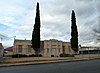
Boulder Dam Hotel
July 13, 1982 (#82003210 ) 1305 Arizona St. 35°58′45″N 114°49′48″W / 35.979167°N 114.83°W / 35.979167; -114.83 (Boulder Dam Hotel ) Boulder City
5
Boulder Dam Park Museum
February 22, 1996 (#96000126 ) Western side of State Route 169 36°31′53″N 114°26′24″W / 36.531389°N 114.44°W / 36.531389; -114.44 (Boulder Dam Park Museum ) Overton Now the Lost City Museum
6
Brownstone Canyon Archeological District
September 22, 1982 (#82003212 ) West of Las Vegas[5] 36°11′01″N 115°25′28″W / 36.1836°N 115.4244°W / 36.1836; -115.4244 (Brownstone Canyon Archeological District ) Las Vegas
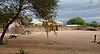
7
Camp Lee Canyon Upload image January 16, 1997 (#96001561 ) State Route 156 approximately 50 miles northwest of Las Vegas in the Spring Mountains National Recreation Area 36°18′32″N 115°40′22″W / 36.308889°N 115.672778°W / 36.308889; -115.672778 (Camp Lee Canyon ) Las Vegas
8
Clark Avenue Railroad Underpass
January 28, 2004 (#03001509 ) Junction of Bonanza Rd. and Union Pacific railroad line 36°10′38″N 115°08′40″W / 36.177222°N 115.144444°W / 36.177222; -115.144444 (Clark Avenue Railroad Underpass ) Las Vegas Also known as the Bonanza Underpass
9
Corn Creek Campsite
March 4, 1975 (#75001105 ) Address Restricted Las Vegas
10
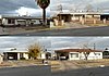
Desert Valley Museum
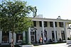
October 24, 1991 (#91001527 ) 31 W. Mesquite Boulevard 36°48′15″N 114°04′05″W / 36.804167°N 114.068056°W / 36.804167; -114.068056 (Desert Valley Museum ) Mesquite Now the Virgin Valley Heritage Museum
11
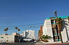
El Cortez Hotel and Casino
February 22, 2013 (#13000010 ) 600 East Fremont Street 36°10′10″N 115°08′19″W / 36.169369°N 115.138628°W / 36.169369; -115.138628 (El Cortez Hotel and Casino ) Las Vegas
12
Eureka Locomotive
January 12, 1995 (#94001575 ) Address Restricted 36°13′40″N 115°12′29″W / 36.227778°N 115.208056°W / 36.227778; -115.208056 (Eureka Locomotive ) Las Vegas
13
Gold Strike Canyon-Sugarloaf Mountain Traditional Cultural Property Upload image September 4, 2004 (#04000935 ) Address Restricted Boulder City
14
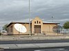
Goodsprings Schoolhouse
March 10, 1992 (#92000121 ) San Pedro Ave. east of its junction with Esmeralda St. 35°49′54″N 115°26′08″W / 35.831611°N 115.435575°W / 35.831611; -115.435575 (Goodsprings Schoolhouse ) Goodsprings
15
Grapevine Canyon Petroglyphs (AZ:F:14:98 ASM)
December 15, 1984 (#84000799 ) Address Restricted Laughlin
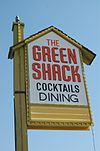
16
Green Shack
June 3, 1994 (#94000552 ) 2504 E. Fremont 36°09′28″N 115°06′53″W / 36.157778°N 115.114722°W / 36.157778; -115.114722 (Green Shack ) Las Vegas Demolished in the 2000s
17
Gypsum Cave Upload image July 8, 2010 (#10000443 ) Sunrise Mountain [6] 36°13′28″N 114°58′37″W / 36.2244°N 114.9769°W / 36.2244; -114.9769 (Gypsum Cave ) Las Vegas
18
Harrison's Guest House
May 3, 2016 (#15000009 ) 1001 F St. 36°10′55″N 115°08′58″W / 36.181967°N 115.149575°W / 36.181967; -115.149575 (Harrison's Guest House ) Las Vegas
19
Hidden Forest Cabin Upload image February 20, 1975 (#75001106 ) About 20 miles north of Las Vegas on Hidden Forest Rd. 36°37′54″N 115°13′05″W / 36.631667°N 115.218056°W / 36.631667; -115.218056 (Hidden Forest Cabin ) Las Vegas
20
Homestake Mine
July 17, 1985 (#85001601 ) Address Restricted Searchlight
21
Hoover Dam
April 8, 1981 (#81000382 ) East of Las Vegas on U.S. Route 93 36°00′58″N 114°44′12″W / 36.016111°N 114.736667°W / 36.016111; -114.736667 (Hoover Dam ) Boulder City National Historic Landmark
22
Parley Hunt House
November 14, 1991 (#91001652 ) Canal St. near its junction with Virgin St. 36°46′32″N 114°06′59″W / 36.775556°N 114.116389°W / 36.775556; -114.116389 (Parley Hunt House ) Bunkerville
23
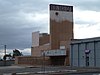
Huntridge Theater
July 22, 1993 (#93000686 ) 1208 E. Charleston Boulevard 36°09′29″N 115°08′07″W / 36.158056°N 115.135278°W / 36.158056; -115.135278 (Huntridge Theater ) Las Vegas
24
Kyle Ranch
October 6, 1975 (#75001107 ) Losee St. and Carey Ave. 36°12′16″N 115°08′21″W / 36.204444°N 115.139167°W / 36.204444; -115.139167 (Kyle Ranch ) North Las Vegas
25
Las Vegas Grammar School
May 20, 1988 (#88000549 ) 400 Las Vegas Boulevard, S. 36°09′53″N 115°08′48″W / 36.164722°N 115.146667°W / 36.164722; -115.146667 (Las Vegas Grammar School ) Las Vegas Also known as the Fifth Street School
26
Las Vegas Grammar School
April 2, 1979 (#79001460 ) Washington and D Sts. 36°10′53″N 115°08′43″W / 36.181389°N 115.145278°W / 36.181389; -115.145278 (Las Vegas Grammar School ) Las Vegas Also known as Westside School
27
Las Vegas High School Academic Building, Gymnasium, and Frazier Hall
September 24, 1986 (#86002293 ) 315 S. 7th St. 36°09′55″N 115°08′20″W / 36.165278°N 115.138889°W / 36.165278; -115.138889 (Las Vegas High School Academic Building, Gymnasium, and Frazier Hall ) Las Vegas Boundary increase (adding Frazier Hall) approved July 22, 2021
28
Las Vegas High School Neighborhood Historic District
January 30, 1991 (#90002204 ) Roughly bounded by E. Bridger, S. 9th, E. Gass, and S. 6th Sts. 36°09′44″N 115°08′23″W / 36.162222°N 115.139722°W / 36.162222; -115.139722 (Las Vegas High School Neighborhood Historic District ) Las Vegas
29
Las Vegas Mormon Fort
February 1, 1972 (#72000764 ) 900 Las Vegas Boulevard, N. 36°10′49″N 115°07′57″W / 36.180278°N 115.1325°W / 36.180278; -115.1325 (Las Vegas Mormon Fort ) Las Vegas There was a boundary increase on December 12, 1978 (refnum 78003379)
30
Las Vegas Springs
December 14, 1978 (#78001719 ) Address Restricted Las Vegas
31
LDS Moapa Stake Office Building
July 25, 2002 (#02000819 ) 161 W. Virginia St. 36°32′25″N 114°26′40″W / 36.540278°N 114.444358°W / 36.540278; -114.444358 (LDS Moapa Stake Office Building ) Overton
32
Thomas Leavitt House
November 14, 1991 (#91001653 ) 160 S. 1st W. St. 36°46′15″N 114°07′37″W / 36.770833°N 114.126944°W / 36.770833; -114.126944 (Thomas Leavitt House ) Bunkerville
33
Little Church of the West
September 14, 1992 (#92001161 ) 4617 Las Vegas Boulevard, S. 36°05′10″N 115°10′19″W / 36.086111°N 115.171944°W / 36.086111; -115.171944 (Little Church of the West ) Paradise Wedding chapel on Las Vegas strip
34
Mesquite High School Gymnasium
March 10, 1992 (#92000119 ) 144 E. N. 1st St. 36°48′18″N 114°03′18″W / 36.805°N 114.055°W / 36.805; -114.055 (Mesquite High School Gymnasium ) Mesquite
35
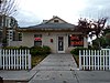
Morelli House
June 3, 2012 (#11001086 ) 861 E. Bridger Ave. 36°09′55″N 115°08′16″W / 36.165363°N 115.137772°W / 36.165363; -115.137772 (Morelli House ) Las Vegas
36
Mormon Well Spring Upload image December 24, 1974 (#74001143 ) North of Las Vegas on Mormon Spring 36°38′39″N 115°05′45″W / 36.644167°N 115.095833°W / 36.644167; -115.095833 (Mormon Well Spring ) Las Vegas
37
Moulin Rouge Hotel
December 22, 1992 (#92001701 ) 900 W. Bonanza Rd. 36°10′40″N 115°09′06″W / 36.177778°N 115.151667°W / 36.177778; -115.151667 (Moulin Rouge Hotel ) Las Vegas Historic non-segregated hotel which was burned after listing; only the neon sign and facade remain
38
Old Boulder City Hospital
April 1, 1982 (#82003211 ) 701 Park Pl. 35°58′45″N 114°49′48″W / 35.979167°N 114.83°W / 35.979167; -114.83 (Old Boulder City Hospital ) Boulder City
39
Old Spanish Trail – Mormon Road Historic District Upload image August 22, 2001 (#01000863 ) From the California border to Arizona across southern Nevada, through Las Vegas; also specifically near the junction of Interstate 15 and State Route 169 36°15′11″N 115°09′43″W / 36.253056°N 115.161944°W / 36.253056; -115.161944 (Old Spanish Trail – Mormon Road Historic District ) Las Vegas and Moapa Junction address represents a boundary increase, added on March 21, 2008
40
Overton Gymnasium
March 10, 1992 (#92000118 ) N. W. Thomas St. west of its junction with S. Anderson St. 36°32′32″N 114°26′53″W / 36.542222°N 114.447917°W / 36.542222; -114.447917 (Overton Gymnasium ) Overton
41
John S. Park Historic District
May 16, 2003 (#03000412 ) Roughly bounded by Charleston Boulevard, Las Vegas Boulevard, Franklin Ave., and S. 9th St. 36°09′24″N 115°08′40″W / 36.156667°N 115.144444°W / 36.156667; -115.144444 (John S. Park Historic District ) Las Vegas
42
Potosi
November 13, 1974 (#74001144 ) South of Las Vegas off Interstate 15 near Potosi Pass 35°58′00″N 115°32′37″W / 35.966667°N 115.543611°W / 35.966667; -115.543611 (Potosi ) Las Vegas
43
Pueblo Grande de Nevada Upload image October 8, 1982 (#82000612 ) Southeast of Overton 36°29′27″N 114°22′21″W / 36.490833°N 114.3725°W / 36.490833; -114.3725 (Pueblo Grande de Nevada ) Overton
44
Railroad Cottage Historic District
December 22, 1987 (#87001622 ) 601-629 S. Casino Center 36°09′50″N 115°08′50″W / 36.163889°N 115.147222°W / 36.163889; -115.147222 (Railroad Cottage Historic District ) Las Vegas All but one cottage destroyed or moved.
45
St. Thomas Memorial Cemetery Upload image January 20, 2005 (#04001529 ) Magnasite Rd. off Moapa Valley Boulevard 36°31′14″N 114°26′06″W / 36.520556°N 114.435°W / 36.520556; -114.435 (St. Thomas Memorial Cemetery ) Overton
46
Sandstone Ranch
April 2, 1976 (#76001141 ) 20 miles southwest of Las Vegas 36°04′04″N 115°27′30″W / 36.067778°N 115.458333°W / 36.067778; -115.458333 (Sandstone Ranch ) Las Vegas Boundary increase approved April 25, 2019
47
Sheep Mountain Range Archeological District Upload image December 31, 1974 (#74001145 ) Address Restricted Las Vegas
48
Sloan Petroglyph Site
December 19, 1978 (#78001720 ) Address Restricted[7] 35°55′53″N 115°11′27″W / 35.9313°N 115.1909°W / 35.9313; -115.1909 (Sloan Petroglyph Site ) Henderson There was a boundary increase on February 5, 2004 (refnum 02000114)
49
Jay Dayton Smith House
February 20, 1987 (#87000077 ) 624 S. 6th St. 36°09′40″N 115°08′39″W / 36.161111°N 115.144167°W / 36.161111; -115.144167 (Jay Dayton Smith House ) Las Vegas
50
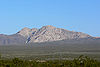
Spirit Mountain
September 8, 1999 (#99001083 ) North of Laughlin in the Lake Mead National Recreation Area [8] 35°16′30″N 114°43′26″W / 35.275°N 114.7239°W / 35.275; -114.7239 (Spirit Mountain ) Laughlin
51
Tim Springs Petroglyphs Upload image December 16, 1974 (#74001142 ) Address Restricted Indian Springs
52
Tule Springs Archeological Site Upload image April 20, 1979 (#79001461 ) Address Restricted Las Vegas
53
Tule Springs Ranch
September 23, 1981 (#81000383 ) 9200 Tule Springs Rd. 36°19′14″N 115°16′01″W / 36.320556°N 115.266944°W / 36.320556; -115.266944 (Tule Springs Ranch ) Las Vegas
54
U.S. Post Office and Courthouse
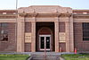
February 10, 1983 (#83001108 ) 300 E. Stewart Ave. 36°10′22″N 115°08′25″W / 36.172778°N 115.140278°W / 36.172778; -115.140278 (U.S. Post Office and Courthouse ) Las Vegas
55
Walking Box Ranch
January 30, 2009 (#08001392 ) 6333 W. State Route 164 35°29′22″N 115°02′25″W / 35.489569°N 115.040208°W / 35.489569; -115.040208 (Walking Box Ranch ) Searchlight
56
Washington School
March 10, 1992 (#92000120 ) 1901 N. White St. 36°11′43″N 115°07′52″W / 36.195278°N 115.131111°W / 36.195278; -115.131111 (Washington School ) North Las Vegas
57
The "Welcome to Fabulous Las Vegas" Sign
May 1, 2009 (#09000284 ) Las Vegas Boulevard , in public right of way, approximately .5 miles (0.8 km) south of intersection with Russell Road36°04′55″N 115°10′22″W / 36.082056°N 115.172778°W / 36.082056; -115.172778 (The "Welcome to Fabulous Las Vegas" Sign ) Paradise
58
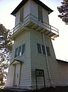
Willow Beach Gauging Station
March 21, 1986 (#86000587 ) Lake Mead National Recreation Area 35°53′17″N 114°40′57″W / 35.888056°N 114.6825°W / 35.888056; -114.6825 (Willow Beach Gauging Station ) Boulder City
59
Woodlawn Cemetery
November 21, 2006 (#06001060 ) 1500 Las Vegas Boulevard, N. 36°11′15″N 115°07′43″W / 36.1875°N 115.128611°W / 36.1875; -115.128611 (Woodlawn Cemetery ) Las Vegas