[4] Name on the Register[5]
Image
Date listed[6]
Location
City or town
Description
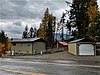
1
Bayview School II
September 12, 1985 (#85002090 ) Careywood Rd. 47°59′02″N 116°33′46″W / 47.983889°N 116.562778°W / 47.983889; -116.562778 (Bayview School II ) Bayview
2
September 12, 1985 (#85002091 ) Hamaker Rd. 47°31′53″N 116°54′54″W / 47.531389°N 116.915°W / 47.531389; -116.915 (Bellgrove School II ) Rockford Bay
3
Cataldo Mission
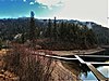
October 15, 1966 (#66000312 ) Off Interstate 90 47°32′55″N 116°21′30″W / 47.548610°N 116.358249°W / 47.548610; -116.358249 (Cataldo Mission ) Cataldo
4
Cave Lake School
September 12, 1985 (#85002092 ) State Highway 3 47°25′20″N 116°36′32″W / 47.422222°N 116.608889°W / 47.422222; -116.608889 (Cave Lake School ) Medimont
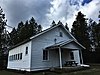
5
September 12, 1985 (#85002093 ) Parks and Lewellyn Creek Rd. 47°55′34″N 116°38′06″W / 47.926111°N 116.635°W / 47.926111; -116.635 (Cedar Mountain School ) Athol
6
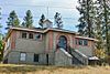
Clark House
December 12, 1978 (#78001070 ) On Hayden Lake 47°45′22″N 116°43′34″W / 47.756245°N 116.726091°W / 47.756245; -116.726091 (Clark House ) Clarksville
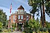
7
Coeur d'Alene City Hall
August 3, 1979 (#79000792 ) 5th and Sherman Sts. 47°40′23″N 116°46′48″W / 47.673182°N 116.779981°W / 47.673182; -116.779981 (Coeur d'Alene City Hall ) Coeur d'Alene
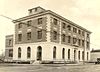
8
Coeur d'Alene Federal Building
December 16, 1977 (#77000461 ) 4th and Lakeside 47°40′28″N 116°46′53″W / 47.674520°N 116.781392°W / 47.674520; -116.781392 (Coeur d'Alene Federal Building ) Coeur d'Alene
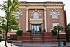
9
Coeur d'Alene Masonic Temple
May 22, 1978 (#78001071 ) 525 Sherman Ave. 47°40′23″N 116°46′43″W / 47.673154°N 116.778511°W / 47.673154; -116.778511 (Coeur d'Alene Masonic Temple ) Coeur d'Alene
10
September 12, 1985 (#85002094 ) Cougar Gulch Rd. 47°38′12″N 116°55′20″W / 47.636688°N 116.922256°W / 47.636688; -116.922256 (Cougar Gulch School III ) Post Falls
11
Silas W. and Elizabeth Crane House
December 9, 1999 (#99001476 ) 201 S. Coeur d'Alene Ave. 47°27′12″N 116°47′09″W / 47.453343°N 116.785708°W / 47.453343; -116.785708 (Silas W. and Elizabeth Crane House ) Harrison
12
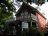
Harvey M. Davey House
May 23, 1985 (#85001126 ) 315 Wallace Ave. 47°40′37″N 116°46′54″W / 47.676962°N 116.781697°W / 47.676962; -116.781697 (Harvey M. Davey House ) Coeur d'Alene
13
September 12, 1985 (#85002095 ) Hayden Lake Rd. 47°47′11″N 116°40′32″W / 47.786389°N 116.675556°W / 47.786389; -116.675556 (East Hayden Lake School II )
14
John A. Finch Caretaker's House
September 14, 1987 (#87001562 ) 2160 Finch Rd. 47°45′30″N 116°45′23″W / 47.758333°N 116.756389°W / 47.758333; -116.756389 (John A. Finch Caretaker's House ) Hayden Lake
15
First United Methodist Church
June 18, 1979 (#79000793 ) 618 Wallace Ave. 47°40′35″N 116°46′37″W / 47.676493°N 116.776987°W / 47.676493; -116.776987 (First United Methodist Church ) Coeur d'Alene
16
Fort Sherman Buildings
October 25, 1979 (#79000794 ) North Idaho College campus47°40′38″N 116°47′51″W / 47.677245°N 116.797380°W / 47.677245; -116.797380 (Fort Sherman Buildings ) Coeur d'Alene
17
John P. and Stella Gray House
March 31, 1988 (#88000272 ) 521 S. 13th St. 47°40′08″N 116°46′06″W / 47.668948°N 116.768200°W / 47.668948; -116.768200 (John P. and Stella Gray House ) Coeur d'Alene
18
October 28, 2021 (#100007118 ) 627 North Government Way 47°40′42″N 116°47′11″W / 47.6783°N 116.7864°W / 47.6783; -116.7864 (Boyd and Alta Hamilton House ) Coeur d'Alene
19
Harrison Commercial Historic District
December 20, 1996 (#96001505 ) Roughly bounded by N. Lake Ave., W. Harrison St., N. Coeur d'Alene., and Pine St. 47°27′15″N 116°47′11″W / 47.454269°N 116.786282°W / 47.454269; -116.786282 (Harrison Commercial Historic District ) Harrison
20
September 12, 1985 (#85002096 ) State Highway 3 47°25′20″N 116°37′23″W / 47.422302°N 116.623188°W / 47.422302; -116.623188 (Indian Springs School II ) Medimont
21
June 27, 1975 (#75000633 ) Mullan Rd. and Northwest Boulevard 47°40′32″N 116°47′19″W / 47.675574°N 116.788669°W / 47.675574; -116.788669 (Inland Empire Electric Railway Substation ) Coeur d'Alene
22
Kootenai County Courthouse
December 23, 1977 (#77000462 ) 501 Government Way 47°40′38″N 116°47′12″W / 47.677245°N 116.786713°W / 47.677245; -116.786713 (Kootenai County Courthouse ) Coeur d'Alene
23
August 10, 2001 (#01000834 ) 802 2nd St. 47°48′40″N 116°53′40″W / 47.811190°N 116.894397°W / 47.811190; -116.894397 (Kootenai County Jail ) Rathdrum
24
September 12, 1985 (#85002097 ) Lanz Rd. 47°30′25″N 116°32′05″W / 47.506944°N 116.534722°W / 47.506944; -116.534722 (Lane School II ) Lane
25
September 12, 1985 (#85002098 ) Corbin Rd. and Old Highway 10 47°43′01″N 116°59′29″W / 47.716852°N 116.991455°W / 47.716852; -116.991455 (McGuires School ) Destroyed by fire in 1987.[7]
26
December 30, 2009 (#09001163 ) 5803 Riverview Dr. 47°41′23″N 116°50′59″W / 47.689706°N 116.849772°W / 47.689706; -116.849772 (Mooney–Dahlberg Farmstead ) Coeur d'Alene
27
Mullan Road
April 5, 1990 (#90000548 ) 3 segments: between Alder Creek and Cedar Creek; Fourth of July Pass between Interstate 80 and old U.S. Route 10 ; Heyburn State Park 47°37′10″N 116°31′06″W / 47.619511°N 116.518455°W / 47.619511; -116.518455 (Mullan Road ) Coeur d'Alene Extends into Benewah County
28
November 19, 2019 (#100004674 ) Address Restricted Athol
29
September 12, 1985 (#85002099 ) Pleasant View Rd. 47°41′27″N 117°00′09″W / 47.690699°N 117.002397°W / 47.690699; -117.002397 (Pleasant View School II )
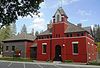
30
Post Falls Community United Presbyterian Church
September 7, 1984 (#84003851 ) 4th and William Sts. 47°42′41″N 116°56′43″W / 47.711267°N 116.945325°W / 47.711267; -116.945325 (Post Falls Community United Presbyterian Church ) Post Falls
31
September 12, 1985 (#85002100 ) Prairie Ave. 47°44′40″N 116°51′33″W / 47.744523°N 116.859140°W / 47.744523; -116.859140 (Prairie School II ) Coeur d'Alene
32
November 8, 1974 (#74000742 ) Main and Mill Sts. 47°48′41″N 116°53′49″W / 47.811317°N 116.896982°W / 47.811317; -116.896982 (Rathdrum State Bank ) Rathdrum Building no longer exists.
33
Roosevelt School
July 30, 1976 (#76000676 ) 1st and Wallace Sts. 47°40′38″N 116°47′06″W / 47.677115°N 116.785000°W / 47.677115; -116.785000 (Roosevelt School ) Coeur d'Alene
34
September 12, 1985 (#85002101 ) Queen St. and State Highway 3 47°32′19″N 116°28′25″W / 47.538652°N 116.473608°W / 47.538652; -116.473608 (Rose Lake School II )
35
St. Stanislaus Kostka Mission
November 17, 1977 (#77000464 ) McCartney and 2nd Sts. 47°48′38″N 116°53′43″W / 47.810674°N 116.895187°W / 47.810674; -116.895187 (St. Stanislaus Kostka Mission ) Rathdrum
36
St. Thomas Catholic Church
October 5, 1977 (#77000463 ) 919 Indiana Ave. 47°40′34″N 116°46′25″W / 47.676168°N 116.773529°W / 47.676168; -116.773529 (St. Thomas Catholic Church ) Coeur d'Alene
37
April 27, 1992 (#92000418 ) Bounded by Garden Ave., Hubbard St., Lakeshore Dr., and Park Dr. 47°40′33″N 116°47′36″W / 47.675863°N 116.793344°W / 47.675863; -116.793344 (Sherman Park Addition ) Coeur d'Alene
38
February 8, 1979 (#79000795 ) Maine St. 47°57′55″N 116°52′13″W / 47.965212°N 116.870409°W / 47.965212; -116.870409 (Spirit Lake Historic District ) Spirit Lake
39
March 20, 2003 (#03000124 ) Diverts in Falls Park, 4th St. 47°42′44″N 116°57′20″W / 47.712233°N 116.955479°W / 47.712233; -116.955479 (Spokane Valley Land and Water Company Canal ) Post Falls
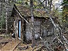
40
Jacob and Cristina Thunborg House Upload image September 12, 1985 (#85002156 ) Chicken Point 47°46′51″N 116°40′59″W / 47.780833°N 116.683056°W / 47.780833; -116.683056 (Jacob and Cristina Thunborg House ) Hayden Lake
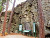
41
April 30, 1992 (#92000420 ) North of Interstate 90 , northeast of the Spokane River falls 47°42′48″N 116°57′06″W / 47.713413°N 116.951683°W / 47.713413; -116.951683 (Treaty Rock ) Post Falls
42
September 12, 1985 (#85002102 ) Twin Lakes Rd. 47°53′40″N 116°54′43���W / 47.894542°N 116.912045°W / 47.894542; -116.912045 (Upper Twin Lakes School )
43
December 20, 1996 (#96001507 ) 0.5 miles west of the junction of Spokane and 4th Sts.47°42′40″N 116°57′12″W / 47.711072°N 116.953327°W / 47.711072; -116.953327 (Washington Water Power Bridges (Canal Bridge) ) 47°42′41″N 116°57′22″W / 47.711356°N 116.956092°W / 47.711356; -116.956092 (Washington Water Power Bridges ) Post Falls
44
Samuel and Ann Young House
July 9, 1997 (#97000765 ) 120 4th Ave. 47°42′39″N 116°56′49″W / 47.710730°N 116.946823°W / 47.710730; -116.946823 (Samuel and Ann Young House ) Post Falls