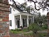
1
Alesia Upload image March 14, 1983 (#83000514 ) 108 North Morgan Avenue 30°08′55″N 91°57′49″W / 30.1486°N 91.9636°W / 30.1486; -91.9636 (Alesia ) Broussard
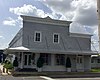
2
Bank of Scott
September 19, 2016 (#16000671 ) 1102 Saint Mary Street 30°14′09″N 92°05′41″W / 30.23588°N 92.0948°W / 30.23588; -92.0948 (Bank of Scott ) Scott
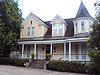
3
Billeaud House Upload image March 14, 1983 (#83000515 ) 303 West Main Street 30°08′53″N 91°57′59″W / 30.1481°N 91.9663°W / 30.1481; -91.9663 (Billeaud House ) Broussard
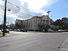
4
Martial Billeaud Jr. House Upload image March 14, 1983 (#83000516 ) 118 North Morgan Avenue 30°08′56″N 91°57′50″W / 30.149°N 91.9640°W / 30.149; -91.9640 (Martial Billeaud Jr. House ) Broussard
5
Brandt House
June 20, 2002 (#02000654 ) 614 Madison St. 30°13′39″N 92°01′12″W / 30.2276°N 92.0200°W / 30.2276; -92.0200 (Brandt House ) Lafayette
6
Valsin Broussard House Upload image March 14, 1983 (#83000517 ) 408 West Main Street 30°08′57″N 91°58′02″W / 30.1493°N 91.9672°W / 30.1493; -91.9672 (Valsin Broussard House ) Broussard
7
Comeaux House Upload image March 14, 1983 (#83000518 ) 101 East 2nd Street 30°09′05″N 91°57′41″W / 30.1513°N 91.9614°W / 30.1513; -91.9614 (Comeaux House ) Broussard
8
Daigle House Upload image June 14, 1984 (#84001298 ) 1012 South Washington Street 30°13′21″N 92°01′20″W / 30.2224°N 92.0222°W / 30.2224; -92.0222 (Daigle House ) Lafayette A Creole cottage , built c.1880 in Greek Revival style.
9
Upload image October 16, 2019 (#100004510 ) 705 Jefferson St., 731 Jefferson St., 735 Jefferson St., 124 E. Main St. 30°13′22″N 92°01′07″W / 30.2229°N 92.0187°W / 30.2229; -92.0187 (Downtown Lafayette Civic Center ) Lafayette
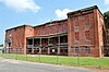
10
Ducrest Building
March 14, 1983 (#83000519 ) 100 West Main Street 30°08′54″N 91°57′51″W / 30.1482°N 91.9642°W / 30.1482; -91.9642 (Ducrest Building ) Broussard
11
Dupleix House Upload image October 4, 1984 (#84000013 ) 106 Lafayette Street 30°05′56″N 91°59′24″W / 30.0990°N 91.9901°W / 30.0990; -91.9901 (Dupleix House ) Youngsville
12
Elrose
June 14, 1984 (#84001305 ) 217 West University Avenue 30°13′05″N 92°01′15″W / 30.2181°N 92.0208°W / 30.2181; -92.0208 (Elrose ) Lafayette
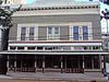
13
Evangeline Hotel
March 17, 1994 (#94000235 ) 302 Jefferson Street 30°13′38″N 92°01′01″W / 30.2272°N 92.0170°W / 30.2272; -92.0170 (Evangeline Hotel ) Lafayette
14
First United Methodist Church
June 21, 1984 (#84001307 ) 703 Lee Avenue 30°13′21″N 92°01′02″W / 30.2225°N 92.0172°W / 30.2225; -92.0172 (First United Methodist Church ) Lafayette
15
Freetown-Port Rico Historic District Upload image February 2, 2016 (#15000694 ) Roughly bounded by East University Avenue, Lee Avenue, Garfield Street, Taft Street, Drain Street, East Pinhook Road, Guidry Street, Refinery Street, Lucille Avenue, Jefferson Street and Coolidge Street 30°13′05″N 92°00′52″W / 30.2181°N 92.0144°W / 30.2181; -92.0144 (Freetown-Port Rico Historic District ) Lafayette
16
Gordon Hotel
June 25, 1982 (#82002778 ) 100-110 East Vermilion Street 30°13′26″N 92°01′07″W / 30.2239°N 92.0185°W / 30.2239; -92.0185 (Gordon Hotel ) Lafayette
17
Holy Rosary Institute
December 3, 1980 (#80001734 ) 421 Carmel Street 30°14′07″N 91°59′52″W / 30.2354°N 91.9978°W / 30.2354; -91.9978 (Holy Rosary Institute ) Lafayette
18
Hope Lodge No. 145
January 21, 1983 (#83000520 ) 116 East Vermilion Street 30°13′26″N 92°01′05″W / 30.2239°N 92.0180°W / 30.2239; -92.0180 (Hope Lodge No. 145 ) Lafayette
19
Janin Store Upload image March 14, 1983 (#83000521 ) 123 North Morgan Avenue 30°08′59″N 91°57′49″W / 30.1497°N 91.9636°W / 30.1497; -91.9636 (Janin Store ) Broussard
20
Upload image October 13, 2020 (#100005680 ) Roughly bounded by East Cypress, Polk, Barry, Lafayette, West Garfield and South Buchanan Sts., Lee Ave., Rue Bibliotheque, and the RR. 30°13′27″N 92°01′00″W / 30.2241°N 92.0166°W / 30.2241; -92.0166 (Lafayette Central Business District ) Lafayette
21
Upload image October 16, 2018 (#100003025 ) 1506 Cameron St. 30°13′56″N 92°01′53″W / 30.2323°N 92.0314°W / 30.2323; -92.0314 (Lafayette Coca-Cola Bottling Plant ) Lafayette
22
Lafayette Elementary School Upload image June 14, 1984 (#84001308 ) 1301 West University Avenue 30°13′29″N 92°01′41″W / 30.2246°N 92.0281°W / 30.2246; -92.0281 (Lafayette Elementary School ) Lafayette
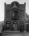
23
Lafayette Hardware Store
June 14, 1984 (#84001309 ) 121 West Vermilion Street 30°13′26″N 92°01′11″W / 30.2239°N 92.0197°W / 30.2239; -92.0197 (Lafayette Hardware Store ) Lafayette
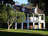
24
Alexandre Latiolais House Upload image May 9, 1985 (#85000972 ) 900 East Butcher Switch Road 30°17′10″N 92°00′02″W / 30.2860°N 92.0006°W / 30.2860; -92.0006 (Alexandre Latiolais House ) Lafayette
25
Main Street Historic District Upload image March 14, 1983 (#83000522 ) 203-305 East Main Street 30°08′52″N 91°57′44″W / 30.1477°N 91.9621°W / 30.1477; -91.9621 (Main Street Historic District ) Broussard
26
Sidney Martin House Upload image November 8, 1984 (#84000351 ) 310 Sidney Martin Road 30°16′42″N 92°00′45″W / 30.2784°N 92.0125°W / 30.2784; -92.0125 (Sidney Martin House ) Lafayette
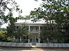
27
Alexandre Mouton House
June 18, 1975 (#75000850 ) 1122 Lafayette Street 30°13′15″N 92°01′16″W / 30.2209°N 92.0210°W / 30.2209; -92.0210 (Alexandre Mouton House ) Lafayette
28
Charles H. Mouton House
June 9, 1980 (#80001735 ) 338 North Sterling Street 30°13′56″N 92°00′36″W / 30.2322°N 92.0099°W / 30.2322; -92.0099 (Charles H. Mouton House ) Lafayette Also part of Sterling Grove Historic District since its creation on July 26, 1984 .[6]
29
Upload image December 23, 2020 (#100005941 ) Roughly bounded by East St. Mary Blvd., West Pinhook Rd., Travis St., Heyman and Audubon Blvds., Harding and Coolidge Sts. 30°12′23″N 92°00′51″W / 30.2065°N 92.0142°W / 30.2065; -92.0142 (Oil Center Historic District ) Lafayette
30
Old Guaranty Bank Building Upload image July 12, 1984 (#84001311 ) 500 Jefferson Street 30°13′33″N 92°01′07″W / 30.2257°N 92.0187°W / 30.2257; -92.0187 (Old Guaranty Bank Building ) Lafayette
31
Old Lafayette City Hall
June 10, 1975 (#75000851 ) 217 West Main Street 30°13′21″N 92°01′14″W / 30.2225°N 92.0205°W / 30.2225; -92.0205 (Old Lafayette City Hall ) Lafayette
32
Our Lady of the Assumption School
November 29, 2001 (#01001267 ) 410 North Michaud Street 30°19′33″N 92°02′34″W / 30.3259°N 92.0427°W / 30.3259; -92.0427 (Our Lady of the Assumption School ) Carencro
33
J. Arthur Roy House Upload image June 14, 1984 (#84001314 ) 1204 Johnston Street 30°13′03″N 92°01′11″W / 30.2174°N 92.0196°W / 30.2174; -92.0196 (J. Arthur Roy House ) Lafayette
34
Roy-LeBlanc House Upload image March 14, 1983 (#83000523 ) 105 South St. Pierre Street 30°08′52″N 91°57′54″W / 30.1477°N 91.9651°W / 30.1477; -91.9651 (Roy-LeBlanc House ) Broussard
35
St. Cecilia School Upload image March 14, 1983 (#83000524 ) 302 West Main Street 30°08′56″N 91°57′58″W / 30.1489°N 91.9660°W / 30.1489; -91.9660 (St. Cecilia School ) Broussard
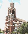
36
St. John's Cathedral
July 27, 1979 (#79001067 ) 515 Cathedral Street 30°13′22″N 92°01′25″W / 30.2229°N 92.0235°W / 30.2229; -92.0235 (St. John's Cathedral ) Lafayette
37
St. Julien House Upload image March 14, 1983 (#83000525 ) 203 East 2nd Street 30°09′03″N 91°57′39″W / 30.1507°N 91.9608°W / 30.1507; -91.9608 (St. Julien House ) Broussard
38
Sterling Grove Historic District Upload image July 26, 1984 (#84001320 ) Roughly bounded by Evangeline Throughway, East Simcoe Street, North Sterling Street and Chopin Street 30°13′58″N 92°00′39″W / 30.2327°N 92.0109°W / 30.2327; -92.0109 (Sterling Grove Historic District ) Lafayette
39
Vermilion Inn
July 13, 1983 (#83000526 ) 1304 Pinhook Road 30°12′02″N 92°00′59″W / 30.2006°N 92.0165°W / 30.2006; -92.0165 (Vermilion Inn ) Lafayette