[3] Name on the Register[4]
Image
Date listed[5]
Location
City or town
Description
1
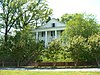
Brownrigg-Harris-Kennebrew House
May 22, 1978 (#78001614 ) 515 9th St. N. 33°30′07″N 88°25′24″W / 33.501944°N 88.423333°W / 33.501944; -88.423333 (Brownrigg-Harris-Kennebrew House ) Columbus
2
Upload image December 8, 1978 (#78001615 ) Address Restricted Columbus
3
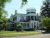
The Cedars
March 29, 1979 (#79001328 ) 1311 Military Rd. 33°30′36″N 88°25′09″W / 33.51°N 88.419167°W / 33.51; -88.419167 (The Cedars ) Columbus
4
November 16, 1988 (#88002396 ) Spans the Tombigbee River on Old U.S. Route 82 33°29′37″N 88°26′03″W / 33.493611°N 88.434167°W / 33.493611; -88.434167 (Columbus Bridge ) Columbus
5
Upload image April 23, 1980 (#80002284 ) U.S. Routes 45 and 82 33°29′47″N 88°25′39″W / 33.496389°N 88.4275°W / 33.496389; -88.4275 (Columbus Central Commercial Historic District ) Columbus
6
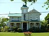
Cox-Uithoven House
May 8, 1980 (#80002285 ) North of Columbus on Old Aberdeen Rd. 33°36′03″N 88°27′28″W / 33.600833°N 88.457778°W / 33.600833; -88.457778 (Cox-Uithoven House ) Columbus
7
William E. Ervin House Upload image December 1, 1989 (#89002053 ) Armstrong Rd./Route 4, southeast of Columbus 33°28′33″N 88°20′40″W / 33.475833°N 88.344444°W / 33.475833; -88.344444 (William E. Ervin House ) Columbus
8
Upload image September 2, 1980 (#80002286 ) Roughly bounded by 2nd and 6th Aves. and 2nd and 5th Sts. 33°29′52″N 88°25′51″W / 33.497778°N 88.430833°W / 33.497778; -88.430833 (Factory Hill-Frog Bottom-Burns Bottom Historic District ) Columbus
9
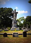
Friendship Cemetery
July 23, 1980 (#80002287 ) 1300 4th St. 33°28′51″N 88°25′50″W / 33.480833°N 88.430556°W / 33.480833; -88.430556 (Friendship Cemetery ) Columbus
10
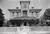
March 21, 1978 (#78001616 ) 1411 College St. 33°29′45″N 88°25′00″W / 33.495833°N 88.416667°W / 33.495833; -88.416667 (Kenneth Gatchell House ) Columbus
11
Harris-Banks House
November 16, 1978 (#78001617 ) 122 7th Ave., S. 33°29′17″N 88°25′52″W / 33.488056°N 88.431111°W / 33.488056; -88.431111 (Harris-Banks House ) Columbus
12
Upload image April 29, 1977 (#77000792 ) 1206 N. 7th St. 33°30′32″N 88°25′31″W / 33.508889°N 88.425278°W / 33.508889; -88.425278 (Hickory Sticks ) Columbus
13
Upload image May 23, 1978 (#78001618 ) Address Restricted Columbus
14
Upload image October 31, 1985 (#85003445 ) 824 8th St., N. 33°30′12″N 88°25′35″W / 33.503333°N 88.426389°W / 33.503333; -88.426389 (Jones-Banks-Leigh House ) Columbus
15
Upload image March 25, 2019 (#100003552 ) 1815 Military Rd. 33°30′56″N 88°25′02″W / 33.5155°N 88.4172°W / 33.5155; -88.4172 (S.D. Lee High School ) Columbus
16
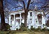
S.D. Lee House
May 6, 1971 (#71000456 ) 314 N. 7th St. 33°29′54″N 88°25′32″W / 33.498333°N 88.425556°W / 33.498333; -88.425556 (S.D. Lee House ) Columbus
17
Upload image June 24, 1993 (#93000574 ) 912 11th Ave., S. 33°29′04″N 88°25′17″W / 33.484444°N 88.421389°W / 33.484444; -88.421389 (Lindamood Building of Palmer Home for Children ) Columbus
18
Upload image August 25, 1978 (#78001619 ) Address Restricted Columbus
19
Charles McLaran House
December 12, 1976 (#76001102 ) 514 2nd St., S. 33°29′24″N 88°25′54″W / 33.49°N 88.431667°W / 33.49; -88.431667 (Charles McLaran House ) Columbus
20
Motley Slough Bridge
November 16, 1988 (#88002405 ) Spans Motley Slough on Shaeffer's Chapel Rd. 33°26′21″N 88°31′08″W / 33.439167°N 88.518889°W / 33.439167; -88.518889 (Motley Slough Bridge ) Columbus
21
Mt. Pleasant Methodist Church
July 5, 2007 (#07000649 ) 2382 Wright Rd. 33°36′31″N 88°20′11″W / 33.608611°N 88.336389°W / 33.608611; -88.336389 (Mt. Pleasant Methodist Church ) Caledonia
22
Old Fort House
October 31, 1985 (#85003444 ) 510 7th St., N. 33°30′00″N 88°25′34″W / 33.5°N 88.426111°W / 33.5; -88.426111 (Old Fort House ) Columbus
23
July 12, 1996 (#96000702 ) 300 Main St. 33°29′40″N 88°25′49″W / 33.494444°N 88.430278°W / 33.494444; -88.430278 (Old St. Paul's Episcopal Church Rectory ) Columbus
24
Upload image March 7, 2007 (#07000122 ) 1709 9th St., S. 33°28′37″N 88°25′20″W / 33.476944°N 88.422222°W / 33.476944; -88.422222 (Owen-Richardson-Owen House ) Columbus
25
Upload image April 22, 1980 (#80002288 ) Address Restricted Columbus
26
Rosedale
June 24, 1994 (#94000642 ) 1523 9th St., S. 33°28′49″N 88°25′15″W / 33.480278°N 88.420833°W / 33.480278; -88.420833 (Rosedale ) Columbus
27
Upload image October 30, 1997 (#97001297 ) 324 9th St., N. 33°29′56″N 88°25′25″W / 33.498889°N 88.423611°W / 33.498889; -88.423611 (Sims-Brown House ) Columbus
28
Upload image October 19, 1978 (#78001620 ) 906 3rd Ave., N. 33°29′54″N 88°25′23″W / 33.498333°N 88.423056°W / 33.498333; -88.423056 (Snowdoun ) Columbus
29
South Columbus Historic District
June 8, 1982 (#82003104 ) U.S. Route 82 ; also 1124 Main St.; also roughly bounded by Main and College Sts., 3rd and 4th Aves. South, 9th' 15th, South 7th and 1st Sts., Tombigbee R.33°28′27″N 88°25′18″W / 33.474167°N 88.421667°W / 33.474167; -88.421667 (South Columbus Historic District ) Columbus Second and third address groups represent boundary changes approved July 27, 2005 and September 29, 2021 .
30
Sykes-Leigh House Upload image March 14, 1985 (#85000555 ) 719-7th St., N. 33°30′08″N 88°25′40″W / 33.502222°N 88.427778°W / 33.502222; -88.427778 (Sykes-Leigh House ) Columbus
31
Upload image March 28, 1979 (#79001329 ) 304 4th Ave., S. 33°29′30″N 88°25′47″W / 33.491667°N 88.429722°W / 33.491667; -88.429722 (Symons House ) Columbus
32
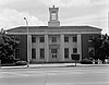
April 21, 1983 (#83000958 ) 524 Main St. 33°29′42″N 88°25′37″W / 33.495°N 88.426944°W / 33.495; -88.426944 (U.S. Post Office ) Columbus
33
Waverly Bridge
March 20, 1989 (#88002412 ) Spans the Tombigbee River on the Columbus and Greenville Railway 33°33′54″N 88°29′48″W / 33.565°N 88.496667°W / 33.565; -88.496667 (Waverly Bridge ) Columbus Extends into Clay County
34
Weaver Place
November 16, 1978 (#78001621 ) 216 3rd Ave., S. 33°29′33″N 88°25′46″W / 33.4925°N 88.429444°W / 33.4925; -88.429444 (Weaver Place ) Columbus