National Register of Historic Places listings in Clay County, Mississippi

From Wikipedia, the free encyclopedia
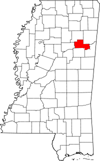
Location of Clay County in Mississippi

This is a list of the National Register of Historic Places listings in Clay County, Mississippi.

This is intended to be a complete list of the properties and districts on the National Register of Historic Places in Clay County, Mississippi, United States. Latitude and longitude coordinates are provided for many National Register properties and districts; these locations may be seen together in a map.[1]

There are 28 properties and districts listed on the National Register in the county, including 1 National Historic Landmark. Another property was once listed but has been removed.

This National Park Service list is complete through NPS recent listings posted February 11, 2022.[2]
Map all coordinates using: OpenStreetMap 
Download coordinates as: KML

Current listings[]

[3] Name on the Register[4] Image Date listed[5] Location City or town Description
1
Dewitt Anderson House
August 31, 1990
(#90001279)
104 W. Broad St.
33°36′15″N 88°39′02″W / 33.604167°N 88.650556°W / 33.604167; -88.650556 (Dewitt Anderson House)
West Point
2 November 15, 1991
(#91001634)
Mississippi Highway 47 at Brandtown, west of Prairie
33°48′03″N 88°51′10″W / 33.800833°N 88.852778°W / 33.800833; -88.852778 (Brandtown Gin Historic District)
Prairie
3 May 24, 1991
(#91000607)
Address Restricted
West Point
4 November 15, 1991
(#91001645)
Between Pheba Sts. Nos. 7 and 8, south of Mississippi Highway 50
33°35′06″N 88°56′48″W / 33.585°N 88.946667°W / 33.585; -88.946667 (Clay County Agricultural High School)
Pheba
5 June 20, 1977
(#77000785)
Western bank of the Tombigbee River, northeast of West Point (Colbert);
on a bluff over the western bank of the Tombigbee River, northeast of West Point (Barton)[6]

33°37′50″N 88°30′15″W / 33.6306°N 88.5042°W / 33.6306; -88.5042 (Colbert and Barton Townsites)
West Point
6
Commerce Street Historic District
August 31, 1990
(#90001283)
508-731 Commerce St.
33°36′06″N 88°38′44″W / 33.601667°N 88.645556°W / 33.601667; -88.645556 (Commerce Street Historic District)
West Point
7 August 12, 1982
(#82004835)
Court Street between Travis and E. Broad Streets
33°36′08″N 88°38′56″W / 33.602222°N 88.648889°W / 33.602222; -88.648889 (Court Street Historic District)
West Point
8 August 31, 1990
(#90001282)
510-1030 E. Main St.
33°36′26″N 88°38′29″W / 33.607222°N 88.641389°W / 33.607222; -88.641389 (East Main Street Historic District)
West Point
9 Mary Holmes Junior College Historic District
Mary Holmes Junior College Historic District
November 15, 1991
(#91001637)
Mississippi Highway 50, west of its junction with U.S. Highway 45, W.W[clarification needed]
33°36′29″N 88°39′55″W / 33.608056°N 88.665278°W / 33.608056; -88.665278 (Mary Holmes Junior College Historic District)
West Point
10 November 15, 1991
(#91001636)
Tibbee-Columbus Rd., south of New Hope Church
33°31′47″N 88°37′53″W / 33.529722°N 88.631389°W / 33.529722; -88.631389 (Charles R. Jordan House)
West Point
11
Moses Jordan House
August 31, 1990
(#90001278)
940 E. Broad St.
33°36′11″N 88°38′33″W / 33.603056°N 88.6425°W / 33.603056; -88.6425 (Moses Jordan House)
West Point
12 November 15, 1991
(#91001638)
Mathews Gin Rd., north of Union Staff Church
33°35′19″N 88°33′43″W / 33.588611°N 88.561944°W / 33.588611; -88.561944 (Nathan Mathews House and Mathews Cotton Gin)
West Point
13 Montpelier Historic District November 15, 1991
(#91001639)
Junction of Mississippi Highways 46 and 389
33°43′02″N 88°56′52″W / 33.717222°N 88.947778°W / 33.717222; -88.947778 (Montpelier Historic District)
Montpelier
14 January 28, 2021
(#100006106)
276 Mary Holmes Row
33°36′33″N 88°40′05″W / 33.6091°N 88.6681°W / 33.6091; -88.6681 (Kenneth G. Neigh Dormitory Complex)
West Point
15 November 15, 1991
(#91001640)
Pheba St. No. 2, just west of Mississippi Highway 389
33°34′52″N 88°57′00″W / 33.581111°N 88.95°W / 33.581111; -88.95 (Pheba Historic District)
Pheba
16 November 15, 1991
(#91001641)
Eastern side of Vail Rd., 1.2 miles north of Mississippi Highway 50
33°36′16″N 88°55′43″W / 33.604444°N 88.928611°W / 33.604444; -88.928611 (Powell-Vail House)
Pheba
17 August 31, 1990
(#90001281)
447-646 S. Division St.
33°36′11″N 88°32′32″W / 33.603056°N 88.542222°W / 33.603056; -88.542222 (South Division Street Historic District)
West Point
18
Tibbee Bridge
November 16, 1988
(#88002411)
Spans Tibbee Creek on Old Tibbee Rd.
33°32′17″N 88°38′00″W / 33.538056°N 88.633333°W / 33.538056; -88.633333 (Tibbee Bridge)
West Point
19 November 15, 1991
(#91001642)
Tibbee-Columbus Rd., at Tibbee
33°31′33″N 88°37′43″W / 33.525833°N 88.628611°W / 33.525833; -88.628611 (Tibbee School)
West Point
20 Town of Palo Alto August 20, 1987
(#87000473)
Mississippi Highway 47, northwest of West Point[7]
33°40′50″N 88°48′00″W / 33.6806°N 88.8°W / 33.6806; -88.8 (Town of Palo Alto)
Palo Alto
21 November 15, 1991
(#91001643)
Turnage Rd., northeast of Palestine Church
33°43′18″N 88°54′41″W / 33.721667°N 88.911389°W / 33.721667; -88.911389 (Turnage House)
Montpelier
22 November 15, 1991
(#91001644)
Una-Prairie Rd., east of Pleasant Grove Church
33°47′45″N 88°47′10″W / 33.795833°N 88.786111°W / 33.795833; -88.786111 (Una Consolidated School)
Prairie
23 July 27, 1999
(#99000842)
Address Restricted
Palo Alto
24 Waverley
Waverley
September 20, 1973
(#73001004)
10 miles east of West Point
33°34′09″N 88°30′13″W / 33.569167°N 88.503611°W / 33.569167; -88.503611 (Waverley)
West Point
25 Waverly Bridge
Waverly Bridge
March 20, 1989
(#88002412)
Spans the Tombigbee River on the Columbus and Greenville railroad line
33°33′54″N 88°29′48″W / 33.565°N 88.496667°W / 33.565; -88.496667 (Waverly Bridge)
Waverly Extends into Lowndes County
26 June 1, 1982
(#82003099)
Mississippi Highway 50
33°36′25″N 88°38′59″W / 33.606944°N 88.649722°W / 33.606944; -88.649722 (West Point Central City Historic District)
West Point
27 August 31, 1990
(#90001280)
Roughly bounded by E. Westbrook, Calhoun, Travis and East Sts.
33°36′04″N 88°38′37″W / 33.601111°N 88.643611°W / 33.601111; -88.643611 (West Point School Historic District)
West Point
28 December 1, 2009
(#09000784)
Roughly bounded by the rear property lines of resources along E. Main St. to the north, McCord St. to the west, and Forest St.
Boundary increase (listed July 25, 2012, refnum 12000561): 117, 123, 133 West Broad St.

33°36′26″N 88°38′05″W / 33.607092°N 88.634694°W / 33.607092; -88.634694 (West Point Unified Historic District)
West Point

Former listing[]

[3] Name on the Register Image Date listedDate removed Location City or town Description
1 November 15, 1991
(#91001635)
June 23, 2003 Mhoon Valley Rd., W of West Point
West Point

See also[]

References[]

  1. ^ The latitude and longitude information provided in this table was derived originally from the National Register Information System, which has been found to be fairly accurate for about 99% of listings. Some locations in this table may have been corrected to current GPS standards.
  2. ^ National Park Service, United States Department of the Interior, "National Register of Historic Places: Weekly List Actions", retrieved February 11, 2022.
  3. ^ a b Numbers represent an alphabetical ordering by significant words. Various colorings, defined here, differentiate National Historic Landmarks and historic districts from other NRHP buildings, structures, sites or objects.
  4. ^ "National Register Information System". National Register of Historic Places. National Park Service. March 13, 2009.
  5. ^ The eight-digit number below each date is the number assigned to each location in the National Register Information System database, which can be viewed by clicking the number.
  6. ^ Locations derived from the GNIS feature records for Colbert and Barton; the NRIS lists the sites as "Address Restricted"
  7. ^ Location derived from its GNIS feature record; the NRIS lists the site as "Address Restricted"
Retrieved from ""