Needles Airport
Needles Airport Needles Army Airfield | |||||||||||||||
|---|---|---|---|---|---|---|---|---|---|---|---|---|---|---|---|
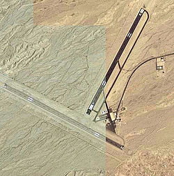 2006 USGS photo | |||||||||||||||
| Summary | |||||||||||||||
| Airport type | Public | ||||||||||||||
| Owner | County of San Bernardino | ||||||||||||||
| Serves | Needles, California | ||||||||||||||
| Elevation AMSL | 983 ft / 300 m | ||||||||||||||
| Coordinates | 34°45′59″N 114°37′24″W / 34.76639°N 114.62333°W | ||||||||||||||
| Website | www.sbcounty.gov/... | ||||||||||||||
| Map | |||||||||||||||
 KEED Location of Needles Airport | |||||||||||||||
| Runways | |||||||||||||||
| |||||||||||||||
| Statistics (2006) | |||||||||||||||
| |||||||||||||||

Needles Airport (IATA: EED, ICAO: KEED, FAA LID: EED) is a county-owned public airport in San Bernardino County, California, United States, five miles (9 km) south of Needles.[1]
It opened in May 1941. During World War II the airfield was known as Needles Army Airfield[2] and was used by the United States Army Air Forces Fourth Air Force. With the end of the war the base returned to civil control.
Facilities and aircraft[]
Needles Airport covers 796 acres (322 ha) at an elevation of 983 feet (300 m) above mean sea level. It has two asphalt runways: 2/20 is 4,235 by 100 feet (1,291 x 30 m) and 11/29 is 5,005 by 100 feet.[1]
In the year ending February 17, 2006 the airport had 10,500 general aviation aircraft operations, an average of 28 per day. 8 aircraft were then based at this airport: 62.5% single-engine and 37.5% ultralight.[1]
See also[]
References[]
![]() This article incorporates public domain material from the Air Force Historical Research Agency website http://www.afhra.af.mil/.
This article incorporates public domain material from the Air Force Historical Research Agency website http://www.afhra.af.mil/.
- ^ a b c d FAA Airport Form 5010 for EED PDF. Federal Aviation Administration. Effective 8 April 2010.
- ^ U.S. Geological Survey Geographic Names Information System: Needles Army Air Field (historical) at coordinates 34°46′00″N 114°37′20″W / 34.76667°N 114.62222°W
External links[]
- Needles Airport at San Bernardino County website
- Aerial image as of 21 May 1994 from USGS The National Map
- FAA Terminal Procedures for EED, effective January 27, 2022
- Resources for this airport:
- FAA airport information for EED
- AirNav airport information for KEED
- ASN accident history for EED
- FlightAware airport information and live flight tracker
- NOAA/NWS weather observations: current, past three days
- SkyVector aeronautical chart, Terminal Procedures
Airports in the Inland Empire | ||
|---|---|---|
| Commercial airports |  | |
| Towered general aviation airports | ||
| Non-towered general aviation airports | ||
| Military airports | ||
| Defunct airports |
| |
| Units |
|  | ||||||||||||||
|---|---|---|---|---|---|---|---|---|---|---|---|---|---|---|---|---|
- Airports in San Bernardino County, California
- Mojave Desert
- Airfields of the United States Army Air Forces in California
- World War II airfields in the United States
- Military facilities in the Mojave Desert
- Needles, California