Negley, Ohio
Negley, Ohio | |
|---|---|
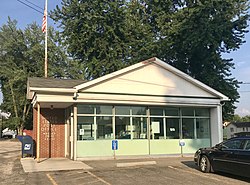 Negley Post Office | |
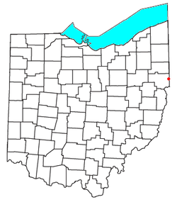 Location of Negley, Ohio | |
| Coordinates: 40°47′24″N 80°32′20″W / 40.79000°N 80.53889°WCoordinates: 40°47′24″N 80°32′20″W / 40.79000°N 80.53889°W | |
| Country | United States |
| State | Ohio |
| County | Columbiana |
| Township | Middleton |
| Area | |
| • Total | 0.9 sq mi (2.3 km2) |
| • Land | 0.9 sq mi (2.3 km2) |
| • Water | 0.0 sq mi (0.0 km2) |
| Elevation | 1,115 ft (340 m) |
| Population (2010) | |
| • Total | 281 |
| • Density | 315/sq mi (121.7/km2) |
| Time zone | UTC-5 (Eastern (EST)) |
| • Summer (DST) | UTC-4 (EDT) |
| ZIP code | 44441 |
| Area code(s) | 234/330 |
| FIPS code | 39-53802 |
| GNIS Feature ID | 1065100 |
| School District | East Palestine City |

Negley is a census-designated place in northeastern Middleton Township, Columbiana County, Ohio, United States. The population was 281 at the 2010 census.[2]
Historically a mining community, Negley is a primarily residential community clustered around Ohio State Route 154. The only former Youngstown and Southern Railroad shop was in Negley. Although the shop is now closed, the current Youngstown and Southeastern Railroad still runs through the town.[3] A Negley post office has been in operation since 1883, now bearing the ZIP code of 44441.
History[]
Negley was the site of a Native American community before European colonization, located on a section of the Great Trail that “crossed the pancake” on the way between Pittsburgh, Pennsylvania and Coshocton, Ohio.[citation needed]
Negley derives its name from Civil War Major General James S. Negley, who hailed from Pittsburgh. After the end of the Civil War, Negley returned to Pittsburgh, served in the U.S. House of Representatives for Pennsylvania, and entered the railroad business. In 1883, the first new town plotted along the New York, Pittsburgh & Chicago Railway line was Negley, named in honor of the president of the railroad company.[4] Negley grew in to a small mining community based from a nearby coal mine operated by the Powers Mining Company.[5]
Education[]
Children in Negley are served by the East Palestine City School District. Negley once had a traditional schoolhouse of its own, and later an elementary school. The current schools serving Negley are:
- East Palestine Elementary School – grades K-4
- East Palestine Middle School – grades 5-8
- East Palestine High School – grades 9-12
Notable people[]
- Ammon Hennacy - Christian anarchist
- Derek Wolfe - NFL defensive end for the Baltimore Ravens
References[]
- ^ "US Board on Geographic Names". United States Geological Survey. 2007-10-25. Retrieved 2008-01-31.
- ^ "Geographic Identifiers: 2010 Demographic Profile Data (G001): Negley CDP, Ohio". U.S. Census Bureau, American Factfinder. Archived from the original on January 26, 2015. Retrieved January 26, 2015.
- ^ McCord, William B. (1905). History of Columbiana County, Ohio and Representative Citizens. Biographical Publishing Company. p. 127.
- ^ "A slice of Negley's history remembered". Lisbon Morning Journal. Retrieved June 29, 2019.
- ^ McCord, William B. (1905). History of Columbiana County, Ohio and Representative Citizens. Biographical Publishing Company. p. 127.
| hide Municipalities and communities of Columbiana County, Ohio, United States | ||
|---|---|---|
| Cities |  | |
| Villages | ||
| Townships | ||
| CDPs | ||
| Unincorporated communities |
| |
| Ghost town | ||
| Footnotes | ‡This populated place also has portions in an adjacent county or counties | |
| ||
This Columbiana County, Ohio state location article is a stub. You can help Wikipedia by . |
- Census-designated places in Columbiana County, Ohio
- 1883 establishments in Ohio
- Northeastern Ohio geography stubs