Nerodimka River
This article needs additional citations for verification. (July 2014) |
Nerodimka
| |
|---|---|
 Bifurcation of River Nerodimka | |
| Location | |
| Country | Kosovo |
| Physical characteristics | |
| Source | |
| • location | Nerodimka mountain |
| Mouth | |
• location | Lepenac, at Kaçanik |
• coordinates | 42°13′31″N 21°15′26″E / 42.2253°N 21.2573°ECoordinates: 42°13′31″N 21°15′26″E / 42.2253°N 21.2573°E |
| Length | 41 km (25 mi) |
| Basin size | 229 km2 (88 sq mi) |
| Basin features | |
| Progression | Lepenac→ Vardar→ Aegean Sea |

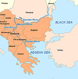
The Nerodimka (Albanian: Nerodimja or Nerodime; Serbian Cyrillic: Неродимка) is a river in the Nerodime region of Kosovo[a], a 41 km-long left tributary to the Lepenc river. It represents Europe's only instance of a river bifurcation flowing into two seas,[1][2] dividing into two irreversible branches. The left branch flows into the Black Sea, and the right branch flows into the Aegean Sea.[1]
For other cases see List of unusual drainage systems.
Geography[]
The Nerodime river rises as Golema Reka in the Nerodime mountain and is formed by the two main tributaries, Golema (Velika) Reka and Mala Reka. They join near the village of Nerodime e Epërme (Gornje Nerodimlje). From there it flows to the outskirts of Ferizaj, where the second bifurcation occurs at 42°22′19″N 21°08′01″E / 42.37192°N 21.13366°E. The northern branch flows into the Sitnica river and ultimately into the Black Sea via the Ibër, Morava and Danube rivers; while the main, southern branch joins with another branch of the Nerodime river and together continue the journey to the Aegean Sea via the Lepenc and Vardar Rivers.[3]
After the major settlement of southern Kosovo, the town of Ferizaj, the Nerodime turns south and flows next to the villages of Varosh, Komogllavë, Kaçanik i Vjetër, Stagovë and Runjevë, before it reaches the town of Kaçanik and empties into the Lepenc river.
The bifurcation is actually an artificial phenomenon, as the connection was achieved by digging an artificial canal, but the downstream water flow is still natural.[4][failed verification] In the 14th century, during the reign of king Milutin, a canal connecting the Sazlia pond and the river Nerodime was dug, creating an artificial bifurcation,[citation needed] since the Nerodimka flows to the south into the Lepenc river and thus belongs to the Aegean Sea drainage basin, while the Sitnica (which is an outflow of the Sazlia) flows to the north, into the Ibër river and belongs to the Black Sea drainage basin. After World War II, the canal was covered with earth again as it was previously mudded as a result of the lack of maintenance.[citation needed]
These water flows have separate impact in annual temperatures of this region. The average annual temperature is 9.9 °C. Warmest months are July and August, with average temperature 18.9 °C. The coldest month is January, with an average temperature -2.6 °C. Maximum air temperature is 32.5 °C in July, while the minimum -14.0 °C in January.[5]
Atmospheric precipitation also plays a role of abundance water in Nerodime river. The average of rainfalls for every month is 73.3 mm. Months with the most rainfalls are April–May, 105.6 mm, while at least August with 42.2 mm.[citation needed]
Development strategies and protection[]
The bifurcation of Nerodime has been under state protection since 1979, and it is declared as a strict wildlife sanctuary, first category according to (IUCN) [4] The official emblem of the municipality of Ferizaj contains the visual representation of the Nerodimka river bifurcation.
This phenomenon is attractive for researchers and visitors and has great importance to education, science and tourism.[citation needed] The western part of the city offers ideal conditions for the formation of public green spaces (parks), for the development of tourism and recreation. Branch of Nerodime River enters within the city, extensive recreational area that is also available to residents of Ferizaj bifurcation area, waterfall and the merger of the two rivers.[6]
The Nerodime drains an area of 229 km2 (88 sq mi) itself, and it is not navigable.
Notes and references[]
Notes:
- ^ The political status of Kosovo is disputed. Having unilaterally declared independence from Serbia in 2008, it is formally recognised as an independent state by 97 UN member states (with another 15 recognising it at some point but then withdrawing recognition), while Serbia continues to claim it as part of its own sovereign territory.
References:
- ^ a b Strategy for Local Economic Development 2005-2007 (PDF). Ferizaj Municipality. 2005. p. 8.
- ^ Vlašković, Zoran (27 May 2013). ""Осавремењена" бифуркација Неродимке" ["Modernized" Bifurcation of Nerodimka] (in Serbian). Fond Slobodan Jovanović. Archived from the original on 6 January 2015. Retrieved 5 January 2015.
- ^ Kosova Environmental Protection Agency (2008–2009). Report on the State of Nature (PDF).
- ^ a b Gashi, Gani. Hydrological heritage in the system of natural values and its protection in Kosova.
- ^ Municipality of Ferizaj (December 2008). Urban Development Plan of Ferizaj (PDF).
- ^ Instituti I Kosoves per mrbojiten e natyres (2005). Values of Nature Legacy of Kosovo (PDF). Pristina.
External links[]
| Wikimedia Commons has media related to Nerodimka (river). |
- The video showing the phenomena
- Protected and Proposed Hydro Monuments in Kosovo[permanent dead link]
- One river flowing into two seas, GBTimes Serbia / Nacionalna revija Srbija

- Tributaries of the Vardar
- Rivers of Kosovo
- Geography of Ferizaj District
- Geography of Prizren District