New Boston, Iowa
New Boston, Iowa | |
|---|---|
 New Boston, Iowa | |
 New Boston Location in Iowa | |
| Coordinates: 40°33′38″N 91°30′20″W / 40.56056°N 91.50556°WCoordinates: 40°33′38″N 91°30′20″W / 40.56056°N 91.50556°W | |
| Country | United States |
| State | Iowa |
| County | Lee |
| Elevation | 696 ft (212 m) |
| Time zone | UTC-6 (Central (CST)) |
| • Summer (DST) | UTC-5 (CDT) |
| Area code(s) | 319 |
| GNIS feature ID | 459469 |


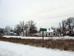
New Boston is an unincorporated community in central Lee County, Iowa, United States. It lies along U.S. Highway 218 southwest of the city of Fort Madison, the county seat of Lee County.[1] New Boston is an unincorporated community. The community is part of the Fort Madison–Keokuk, IA-MO Micropolitan Statistical Area. There are no commercial establishments in New Boston, although this is the home of the New Boston Mennonite Church.
History[]
Founded in the 1800s, New Boston's population was 56 in 1902,[2] and 26 in 1925.[3]
References[]
- ^ Google Maps, https://maps.google.com
- ^ Cram's Modern Atlas: The New Unrivaled New Census Edition. J. R. Gray & Company. 1902. pp. 203–207.
- ^ Company, Rand McNally and (1925). Premier Atlas of the World: Containing Maps of All Countries of the World, with the Most Recent Boundary Decisions, and Maps of All the States,territories, and Possessions of the United States with Population Figures from the Latest Official Census Reports, Also Data of Interest Concerning International and Domestic Political Questions. Rand McNally & Company. p. 190.
Municipalities and communities of Lee County, Iowa, United States | ||
|---|---|---|
| Cities |  | |
| Townships | ||
| CDPs | ||
| Other communities | ||
| ||
This article about the geography of Lee County, Iowa is a stub. You can help Wikipedia by . |
Categories:
- Unincorporated communities in Lee County, Iowa
- Unincorporated communities in Iowa
- Fort Madison–Keokuk, IA-IL-MO Micropolitan Statistical Area
- Southeast Iowa geography stubs